Three-dimensional surface deformation monitoring method fusing multi-source SAR data

A technology of surface deformation and data, applied in the direction of electric/magnetic solid deformation measurement, measuring device, point coordinate measurement, etc., can solve the problems of not dense observation point density, time-consuming and laborious, etc.

Pending Publication Date: 2020-12-08
广东省核工业地质局测绘院
View PDF0 Cites 3 Cited by
  • Summary
  • Abstract
  • Description
  • Claims
  • Application Information

AI Technical Summary

Problems solved by technology

[0003] Precise leveling, GNSS observation, and on-site sensor observation included in traditional measurement technology have disadvantages such as time-consuming and laborious, and the density of observation points is not dense.

Method used


Image

  • Three-dimensional surface deformation monitoring method fusing multi-source SAR data
  • Three-dimensional surface deformation monitoring method fusing multi-source SAR data
  • Three-dimensional surface deformation monitoring method fusing multi-source SAR data

Examples


Embodiment 1

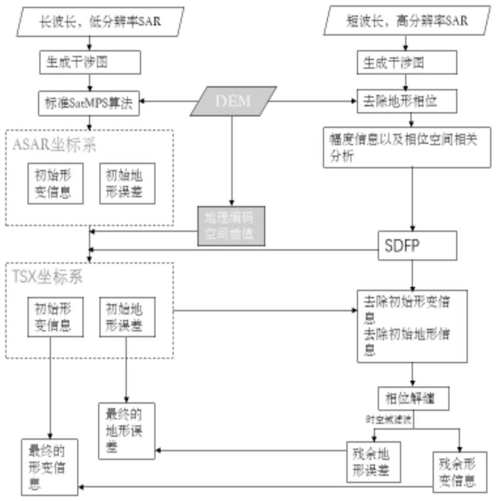
[0044] The invention proposes a method for monitoring and solving three-dimensional surface deformation by fusing multi-source SAR images.

[0045] In order to achieve the above object, the present invention adopts the following technical solutions:

[0046] A method for monitoring and solving three-dimensional surface deformation in industrial and mining areas fused with multi-source SAR images, comprising the following steps:

[0047] a Estimate the initial deformation and terrain error;

[0048] b Extract SDFP on the basis of high-resolution SAR images;

[0049] c The geocoding method is used to register the two SAR images;

[0050] d-space interpolation;

[0051] e fuse the deformation information;

[0052] f Fusion of terrain error information;

[0053] g phase unwrapping;

[0054] h separate residual deformation and residual terrain error information;

[0055] i synthesize the final deformation information and terrain error information;

[0056] Further, the step a...


PUM


Abstract

The invention discloses a three-dimensional surface deformation monitoring method fusing multi-source SAR data. According to the method, multi-source SAR images, namely ASAR data and TSX data, are fused, the ASAR data is low in spatial resolution and weak in ground object information description capability, but the ASAR data are wide in breadth, and the TSX data are very high in spatial resolutionbut narrow in breadth, so that the spatial resolution and the spatial coverage area are considered. ASAR data and TSX data are fused to carry out earth surface deformation monitoring, the two imagesare fused to achieve the purpose of advantage and disadvantage complementation, the application prospect of InSAR earth surface monitoring is expanded, and the earth surface observation cost and technical limitation are reduced. On the basis, simulation is carried out by establishing a deformation model, the three-dimensional deformation condition of the earth surface can be better and more visually obtained, and suggestions can be effectively provided for preventing geological disasters. And meanwhile, better opinions are provided for the development of the society, which is of great significance to the society and people.

Description

technical field [0001] The invention relates to the field of three-dimensional surface monitoring, in particular to a method for monitoring three-dimensional surface deformation by fusing multi-source SAR data. Background technique [0002] Surface subsidence refers to the continuous subsidence of the surface soil layer within a period of time. When this phenomenon exists for a long time without improvement, it will develop into a serious geological disaster. Therefore, it is particularly urgent to obtain the three-dimensional deformation data of the surface accurately and efficiently. It is of great significance to the development of society to continuously monitor the earth's surface and study its changing law and formation mechanism. [0003] Precise leveling, GNSS observations, and on-site sensor observations, which are included in traditional surveying techniques, have disadvantages such as time-consuming and laborious, and the density of observation points is not dens...

Claims


Application Information

Patent Timeline
Patent Type & Authority Applications(China)
IPC IPC(8): G01S13/90G01B7/004G01B7/16G01C5/00
CPCG01B7/004G01B7/16G01C5/00G01S13/9023G01S13/9094
Inventor 徐平杨新忠李智强邓利平陈敏
Owner 广东省核工业地质局测绘院
Why Eureka
Try Eureka