Method for realizing water area shoreline dynamic monitoring by utilizing high-resolution remote sensing technology

A remote sensing technology and dynamic monitoring technology, applied in the field of remote sensing science, can solve the problems of difficult cross-regional river management, difficult shoreline management, and imperfect monitoring system, and achieve fast information acquisition, short cycle, and large monitoring range. Effect

Inactive Publication Date: 2020-12-18
山东锋士信息技术有限公司
View PDF4 Cites 4 Cited by
  • Summary
  • Abstract
  • Description
  • Claims
  • Application Information

AI Technical Summary

Problems solved by technology

[0005] Aiming at the deficiencies of the prior art, the present invention provides a method for realizing the dynamic monitoring of the shoreline of water areas by using high-resolution remote sensing technology, which solves the traditional way of river and lake supervision. Difficult management of regional rivers, time-consuming and labor-intensive monitoring, and imperfect monitoring system

Method used


Image

  • Method for realizing water area shoreline dynamic monitoring by utilizing high-resolution remote sensing technology

Examples


Embodiment Construction

[0025] The technical solutions in the embodiments of the present invention will be clearly and completely described below with reference to the accompanying drawings in the embodiments of the present invention. Obviously, the described embodiments are only a part of the embodiments of the present invention, rather than all the embodiments. Based on the embodiments of the present invention, all other embodiments obtained by those of ordinary skill in the art without creative efforts shall fall within the protection scope of the present invention.

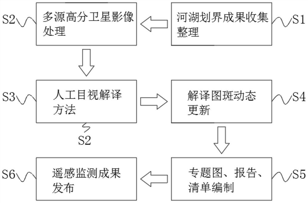
[0026] see figure 1 , the embodiment of the present invention provides a technical solution: a method for realizing dynamic monitoring of water coastlines by using high-resolution remote sensing technology, which specifically includes the following steps:

[0027] S1. Collection and arrangement of river and lake demarcation results: focus on collecting vector data of river management range, check and correct the demarcation data with...


PUM


Abstract

The invention discloses a method for realizing water area shoreline dynamic monitoring by using a high-resolution remote sensing technology, which comprises the following steps: S1, river and lake demarcation result collection and arrangement: focusing on collecting river channel management range vector data and taking a sky map as a base map. The invention relates to the technical field of remotesensing science. According to the method for realizing dynamic monitoring of the water area shoreline by utilizing the high-resolution remote sensing technology, aiming at a large-area river and lakewater system and a complex river and lake environment, the high-resolution remote sensing technology has the advantages of high spatial resolution, rich information amount, wide monitoring range, short coverage period, low acquisition cost and convenience in long-term dynamic monitoring. According to the method, high-resolution remote sensing data is preprocessed to obtain an orthoimage base mapcovering rivers and lakes, and illegal information such as river channel invasion, lake reclamation, illegal sand mining and the like are identified and extracted by combining a water area shoreline demarcation management range and utilizing an artificial visual interpretation and on-site review method. Comprehensive supervision of river and lake illegal information and dynamic tracking of rectification effect are realized.

Description

technical field [0001] The invention relates to the field of remote sensing science and technology, in particular to a method for realizing dynamic monitoring of water coastlines by utilizing high-resolution remote sensing technology. Background technique [0002] Remote sensing technology is a detection technology that emerged in the 1960s. Based on the theory of electromagnetic waves, various sensing instruments are used to collect, process, and finally image the electromagnetic wave information radiated and reflected by long-distance targets. It is a comprehensive technology for detecting and identifying various scenes. Through remote sensing technology, domestic high-resolution remote sensing images such as Gaofen-1, Gaofen-2, and Ziyuan-3 can be queried. [0003] The economy continues to grow, the industrialization and urbanization process is accelerated, and the requirements for the utilization of river and lake shorelines are getting higher and higher. The traditional...

Claims


Application Information

Patent Timeline
IPC IPC(8): G06F16/29G06Q10/06G06T11/20
CPCG06Q10/06313G06T11/206G06F16/29Y02A20/402
Inventor 孙启玉郭伟李红超
Owner 山东锋士信息技术有限公司
Why Eureka
Try Eureka