Slope monitoring method based on multiple unmanned aerial vehicles

A technology for unmanned aerial vehicles and slopes, which is applied in the direction of motor vehicles, measuring devices, and photo interpretation. It can solve the problems of error in detection results and difficulty in ensuring the accuracy of monitoring results, so as to ensure accuracy and shorten the time required for monitoring. Effect

Active Publication Date: 2020-12-29
CHINA MERCHANTS CHONGQING COMM RES & DESIGN INST
View PDF12 Cites 3 Cited by
  • Summary
  • Abstract
  • Description
  • Claims
  • Application Information

AI Technical Summary

Problems solved by technology

More importantly, the environment of the slope is changeable. If a single UAV is affected by the environment, it will inevitably lead to large errors in the detection results. Therefore, it is difficult to guarantee the accuracy of the monitoring results when using a single UAV for monitoring.

Method used


Image

  • Slope monitoring method based on multiple unmanned aerial vehicles
  • Slope monitoring method based on multiple unmanned aerial vehicles
  • Slope monitoring method based on multiple unmanned aerial vehicles

Examples


Embodiment Construction

[0037] Embodiments of the technical solutions of the present invention will be described in detail below in conjunction with the accompanying drawings. The following examples are only used to illustrate the technical solutions of the present invention more clearly, and therefore are only examples, rather than limiting the protection scope of the present invention.

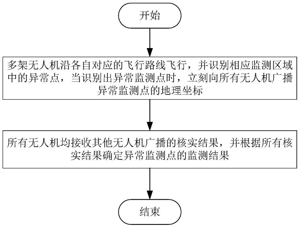
[0038] As shown in the figure, the flow chart of the slope monitoring method based on multiple drones, the monitoring method includes:

[0039] Step 1-1, each UAV flies along the preset flight route, and identifies the abnormal monitoring point in the corresponding monitoring area, when the abnormal monitoring point is identified, broadcast the geographical coordinates of the abnormal monitoring point to other UAVs, In order to facilitate other drones to verify the recognition results based on geographic coordinates;

[0040] Step 1-2, receiving the verification results broadcast by other UAVs, and determining the...


PUM


Abstract

The invention provides a slope monitoring method based on the multiple unmanned aerial vehicles. The slope monitoring method comprises the steps that multiple monitoring points can be arranged on a slope, all the unmanned aerial vehicles can pass through the slope according to a preset flight route and monitor passing monitoring areas in real time, and when the unmanned aerial vehicles monitor that an abnormal monitoring point with displacement exists in the monitoring areas, the unmanned aerial vehicles can broadcast the geographic coordinates of the abnormal monitoring point to other unmanned aerial vehicles. After other unmanned aerial vehicles receive the geographic coordinates of the abnormal monitoring point, the abnormal condition at the geographic position corresponding to the geographic coordinates can be verified, a verification result is broadcasted to all the unmanned aerial vehicles, and after all the unmanned aerial vehicles receive the verification result broadcasted bythe other unmanned aerial vehicles, whether the monitoring point corresponding to the geographic coordinates truly shifts or not can be judged by integrating the verification results fed back by all the unmanned aerial vehicles. Thus, the verification results can be verified from different positions, directions and the like through the multiple unmanned aerial vehicles, the abnormal monitoring point can be accurately recognized, and the accuracy of the monitoring results is ensured.

Description

technical field [0001] The invention relates to the technical field for measuring ground deformation and movement, in particular to a slope monitoring method based on multiple unmanned aerial vehicles. Background technique [0002] In order to grasp the movement of slope rocks and find signs of slope failure, it is necessary to monitor the speed and direction of slope displacement. UAVs can also be used for slopes because they have a wide monitoring range and are not affected by the geographical environment. monitor. For example, the patent "UAV-Based Highway High Slope Inspection Method" (publication number CN109695260A) specifically discloses a method for monitoring highway slopes by using an unmanned aerial vehicle. The patent "A System and Method for Monitoring Slope Deformation" (Notice No. CN110453731B) discloses a technical means of monitoring dam deformation using unmanned aerial vehicles. The patent "A Method for Three-dimensional Visual Modeling of Highway Slopes...

Claims


Application Information

Patent Timeline
Patent Type & Authority Applications(China)
IPC IPC(8): G01B21/32G01C11/02G01C11/04B64C39/02
CPCG01B21/32G01C11/02G01C11/04B64C39/02
Inventor 黄河阎宗岭贾学明李海平谭玲毛友平王立洪袁青海
Owner CHINA MERCHANTS CHONGQING COMM RES & DESIGN INST
Why Eureka
Try Eureka