A downsampling method of insar interferogram based on topological analysis technology

A technology of topology analysis and interferogram, applied in the direction of radio wave reflection/re-radiation, instruments, measuring devices, etc., to reduce the generation of redundant data, avoid oversampling, and improve the efficiency of data compression

Active Publication Date: 2022-08-05
WUHAN UNIV
View PDF10 Cites 0 Cited by
  • Summary
  • Abstract
  • Description
  • Claims
  • Application Information

AI Technical Summary

Problems solved by technology

[0004] The present invention solves the problem of over-sampling in the far field of the traditional quadtree sampling method in the prior art by providing an InSAR interferogram down-sampling method fused with topology analysis technology

Method used


Image

  • A downsampling method of insar interferogram based on topological analysis technology
  • A downsampling method of insar interferogram based on topological analysis technology
  • A downsampling method of insar interferogram based on topological analysis technology

Examples


Embodiment 1

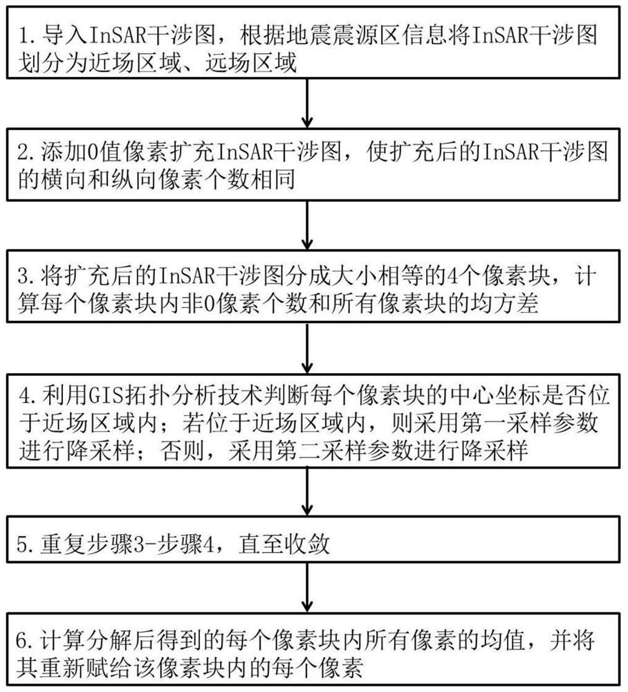
[0037] Embodiment 1 provides an InSAR interferogram downsampling method fused with topology analysis technology. According to the information of the earthquake source area, a near-field area and a far-field area are set within the spatial coverage of the interferogram; the GIS topology analysis technology is used to identify the interferogram. The area where the middle pixel is located; the first sampling parameter is used for down-sampling of the interferogram in the near-field area, and the second sampling parameter is used for the down-sampling of the interferogram in the far-field area.

[0038] The invention mainly includes three parts: GIS topology analysis, parameter setting and sub-regional sampling.

[0039]The GIS topology analysis refers to judging whether the pixel block to be divided belongs to the near field area. GIS topology analysis is a technology for determining the positional relationship between points, lines, and surfaces in geographic information space. ...

Embodiment 2

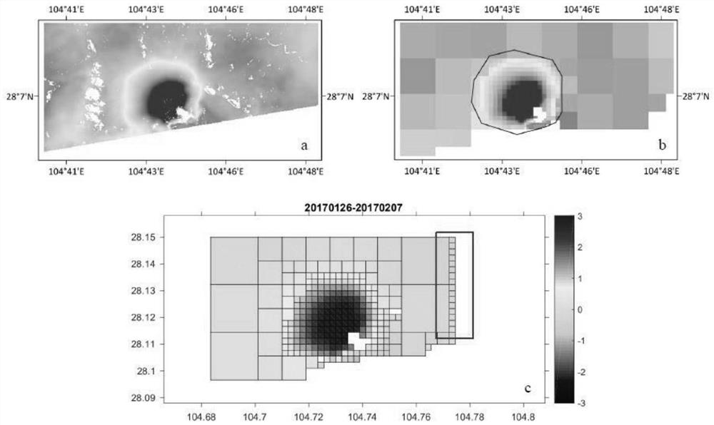
[0057] Taking the InSAR deformation monitoring interferogram of an earthquake that occurred in my country on January 27, 2017 as an example, the interferogram was obtained by differential interferometry using two up-orbit (orbit number T055) data of the ESA sentinel radar satellite.

[0058] 1) First import the image to the interface, and then manually draw a closed curve according to the known information as the near-field range. Save the closed curve as graphic element "123".

[0059] 2) Click the "Image Compression-Quadtree" function, set the maximum block size of the near field to 16*16 pixels, the minimum block size to 4*4 pixels; the maximum block size of the far field to be 64*64 pixels, and the minimum block size to be 64*64 The block is 16*16 pixels; set the minimum variance threshold to 0.001 and the maximum threshold to 0.07; set the filter factor (pixels with value / total pixels of the block) to 0.5; set the main deformation area to "123".

[0060] Select the save ...

Embodiment 3

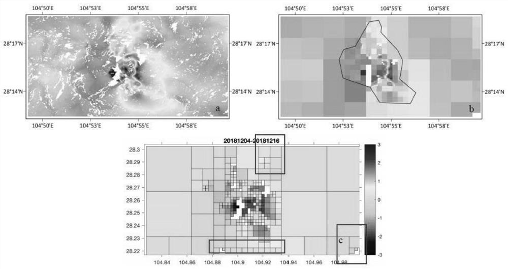
[0063] Taking the InSAR deformation monitoring interferogram of an earthquake that occurred in my country on December 16, 2018 as an example, the interferogram was obtained by differential interferometry using two data of the ESA sentinel radar satellite's orbit-up (orbit number: T128).

[0064] 1) First import the image to the interface, and then manually draw a closed curve according to the known information as the near-field range. Save the closed curve as graphic element "123".

[0065] 2) Click the "Image Compression-Quadtree" function, set the maximum near-field block to 32*32 pixels, the minimum block to 4*4 pixels; the far-field maximum block to 128*128 pixels, and the minimum The block is 16*16 pixels; the minimum variance threshold is set to 0.01, and the maximum threshold is 0.073; the filter factor (valued pixels / total pixels of the block) is set to 0.5; the main deformation area is set to "123".

[0066] 3) Select the save path of "image data" and "point data" in...


PUM


Abstract

The invention belongs to the technical field of image compression, and discloses an InSAR interferogram downsampling method integrating topology analysis technology. In the down-sampling process of the InSAR interferogram, according to the earthquake source area information, two regions, the near-field and the far-field, are set within the spatial coverage of the interferogram; and the GIS topology analysis technology is used to identify the regions where the pixels in the interferogram are located; The interferogram downsampling in each region adopts two different sets of parameters. The invention solves the problem that the traditional quadtree sampling method in the prior art frequently occurs over-sampling in the far-field region of the interferogram, avoids the generation of redundant data, effectively reduces the amount of data, and improves the data compression efficiency.

Description

technical field [0001] The invention relates to the technical field of image compression, in particular to an InSAR interferogram downsampling method integrating topology analysis technology. Background technique [0002] Synthetic aperture radar interferometry (Interferometric Synthetic Aperture Radar, InSAR) is a new microwave remote sensing technology developed rapidly in recent decades, which can accurately measure the three-dimensional information and elevation change information of the surface. It has the characteristics of high resolution, high coverage, and is not constrained by regional environment and climate. It can better solve the problem of insufficient deformation information obtained by artificially laying observation points in traditional three-dimensional space and difficulty in collecting information in harsh areas. Therefore, it is possible to obtain more deformation signals and reveal more geophysical phenomena, providing a new way for geophysical invers...

Claims


Application Information

Patent Timeline
Patent Type & Authority Patents(China)
IPC IPC(8): G01S13/90
CPCG01S13/9023
Inventor 江国焰许才军
Owner WUHAN UNIV
Why Eureka
Try Eureka