Design method for precise strike to ground based on relative satellite navigation

A technology of satellite navigation and design method, applied to offensive equipment, projectiles, self-propelled bombs, etc., can solve the problem of not being able to generate geographic coordinates in real time, and achieve the goal of low aircraft performance requirements, reduced mission time, and improved ground strike accuracy. Effect

Active Publication Date: 2021-01-29
LUOYANG INST OF ELECTRO OPTICAL EQUIP OF AVIC
View PDF6 Cites 1 Cited by
  • Summary
  • Abstract
  • Description
  • Claims
  • Application Information

AI Technical Summary

Problems solved by technology

To use satellite-guided bombs, it is necessary to book precise target coordinates in advance, carry out precise strikes on facing targets, and use photoelectric sensors for target positioning. Due to the existence of satellite positioning errors and target positioning errors, it is impossible to generate geographical coordinates with sufficient accuracy in real time to meet satellite-guided munitions Accuracy requirements for attacking the target

Method used


Image

  • Design method for precise strike to ground based on relative satellite navigation

Examples


Embodiment

[0031] Step 1: Determine the participating units and capability requirements:

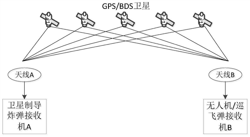
[0032] Combat mission aircraft: mount satellite-guided bombs, have a data link, and can receive images and position information returned by small drones or loitering bombs;

[0033] Small unmanned aerial vehicles / loitering bombs: equipped with data links and TV seekers, capable of performing flight tasks based on image recognition or link control instructions;

[0034] Small UAV / cruising bomb operator: If the small UAV / cruising bomb is launched from the aircraft, the operator is the pilot on the plane; if the small UAV / cruising bomb is launched on the ground, the operator is the ground guide;

[0035] Step 2: Implementation process of ground precision strike:

[0036] Step 2.1: Mission preparation phase: Obtain the rough location information of the target through intelligence, the combat mission aircraft arrive at the designated mission area, lock the tracking satellite and add ephemeris, and ensu...


PUM


Abstract

The invention provides a design method for precise strike to the ground based on relative satellite navigation. A weapon accurate striking method is designed according to each stage of using a satellite guided bomb to strike a ground target by a combat aircraft, the striking accuracy of a fire control system is effectively improved, all-weather attacks are supported, the safety of the combat aircraft is effectively guaranteed, and the task cost and the task time are reduced. According to the method, the combat aircraft safety is guaranteed, the task cost is reduced, the task time is shortened,system errors accounting for about 85% of satellite positioning errors can be eliminated, only 15% of random errors are left, and the ground striking precision of the fire control system is greatly improved.

Description

technical field [0001] The invention relates to the field of aviation fire control, in particular to a design method for ground precision strikes based on relative satellite navigation technology using satellite-guided bombs for combat aircraft. Background technique [0002] When active combat aircraft use precision strike weapons to carry out attack missions on the ground, the fire control system achieves precise positioning of ground targets, usually by obtaining intelligence in advance or real-time detection by airborne sensors. With the expansion of the modern combat area and the complexity of the situation, it becomes unrealistic to rely on intelligence support to complete target positioning, and the time and cost are unacceptable; using airborne sensors to accurately locate the target, as the target distance increases, the positioning error is rapid increase, unable to meet the positioning accuracy requirements of precise strikes. [0003] The use of satellite-guided ...

Claims


Application Information

Patent Timeline
Patent Type & Authority Applications(China)
IPC IPC(8): F42B15/01
CPCF42B15/01
Inventor 郭立敏王雪王海勃
Owner LUOYANG INST OF ELECTRO OPTICAL EQUIP OF AVIC
Why Eureka
Try Eureka