A method and system for integrated geometric and semantic processing of multi-source remote sensing satellite images

A technology of remote sensing images and remote sensing satellites, which is applied in the field of surveying and mapping science and can solve problems such as image color cast, mosaic line image dislocation, and reduce geometric accuracy, so as to achieve the effect of improving elevation accuracy, ensuring elevation accuracy, and improving relative accuracy

Active Publication Date: 2021-07-20
WUHAN UNIV
View PDF9 Cites 0 Cited by
  • Summary
  • Abstract
  • Description
  • Claims
  • Application Information

AI Technical Summary

Problems solved by technology

However, in this type of processing system, the role of semantic information in the synthesis of multi-source remote sensing satellite images has not been played.
[0003] In the absence of semantic information, the high-precision synthesis of multi-source images will encounter the following problems: ① image matching points may be distributed on unstable features such as clouds, water surfaces, ice and snow, which reduces the accuracy of geometric fine correction; ② automatic matching to obtain The control points may be distributed on "non-ground surfaces" such as buildings, and such control points cannot automatically obtain accurate elevations from the DEM; ③ Clouds, cloud shadows, ice and snow, etc. 4. In the absence of building and tree coverage information, the mosaic line may pass through such obstacles, resulting in dislocation of the images on both sides of the mosaic line
These problems, on the one hand, reduce the quality of automatic multi-source remote sensing synthetic image production (such as reducing geometric accuracy, causing halo phenomenon in fused images, causing image color cast after uniform light and color, etc.), and on the other hand, make some work only It can only be completed through a lot of manual intervention (such as bypassing obstacles such as buildings and trees by manually editing mosaic lines)

Method used


Image

  • A method and system for integrated geometric and semantic processing of multi-source remote sensing satellite images
  • A method and system for integrated geometric and semantic processing of multi-source remote sensing satellite images
  • A method and system for integrated geometric and semantic processing of multi-source remote sensing satellite images

Examples


Embodiment Construction

[0075] In order to facilitate those of ordinary skill in the art to understand and implement the present invention, the present invention will be described in further detail below in conjunction with the accompanying drawings and embodiments. It should be understood that the implementation examples described here are only used to illustrate and explain the present invention, and are not intended to limit this invention.

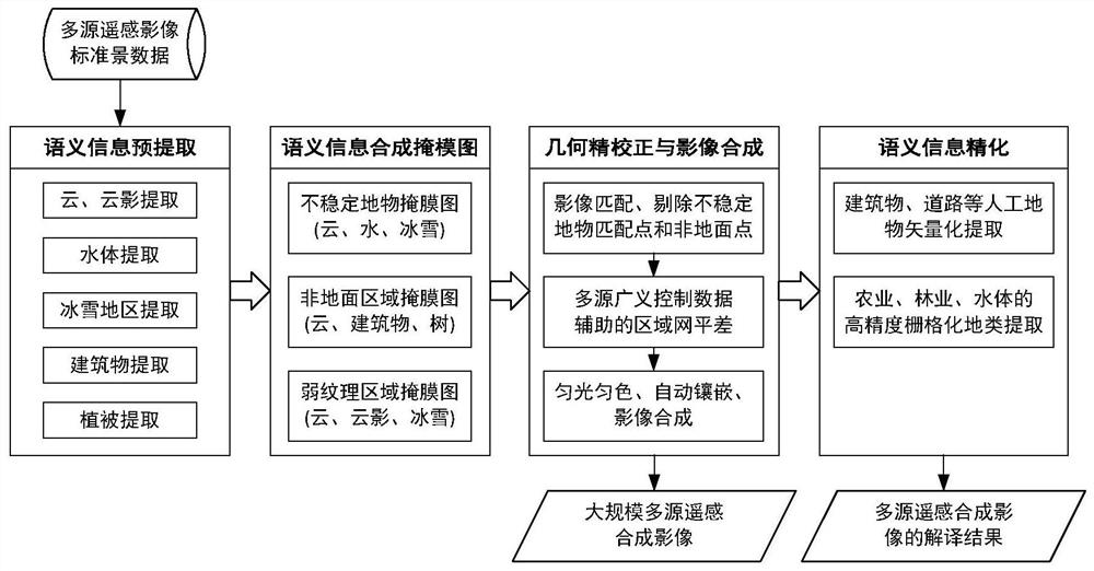
[0076] Step 1: Semantic information pre-extraction of standard scene remote sensing images

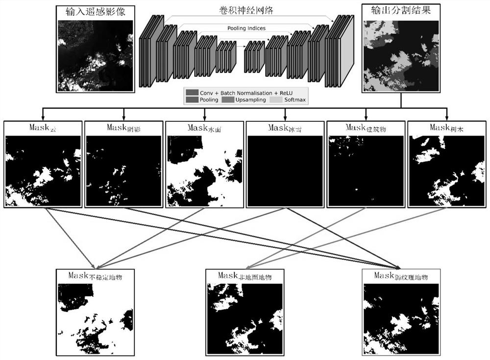
[0077] A convolutional neural network consists of one or more convolutional layers, pooling layers, and a fully connected layer on top. This structure enables convolutional neural networks to take advantage of the two-dimensional structure of the input data. Convolutional neural networks can give better results in image recognition than other deep learning structures. This method uses the existing fully convolutional network (such as UNet, DeepLab, etc.) to extract ...


PUM


Abstract

The invention discloses a multi-source remote sensing satellite image geometry and semantics integrated processing method and system. The method is different from the traditional scheme of performing geometric precision correction on remote sensing images first, and then performing semantic segmentation and information extraction, and proposes a method that includes semantic information Extraction, automatic geometric fine correction assisted by semantic information, and semantic information optimization are three steps. Firstly, from the standard scene images, the cloud, water surface, ice and snow, cloud shadows, artificial buildings and other terrain information that have a great influence on the geometric precision correction are preliminarily extracted, and then with the assistance of these information, interference is eliminated to realize fully automatic remote sensing images. Geometric precision correction, uniform light and color, seamless mosaic, image synthesis and other processing, and finally in the high-precision multi-source composite image, extract richer semantic information and target information, and obtain ultra-large-scale multi-source composite image and its corresponding semantics Maps and thematic maps of land types.

Description

technical field [0001] The invention belongs to the field of surveying and mapping science and technology, and relates to a multi-source remote sensing satellite image geometric and semantic integrated processing method and system. Background technique [0002] The workflow of the early multi-source satellite image geometric fine correction and semantic segmentation processing system generally first obtains high-precision multi-source remote sensing satellite synthesis through processes such as image matching, block adjustment, orthorectification, image uniformity, and mosaic. Image, and then obtain semantic information such as target information, ground object coverage information, etc. from the synthetic image through intelligent means or artificial means. But in this kind of processing system, the role of semantic information in the synthesis of multi-source remote sensing satellite images has not been played. [0003] In the absence of semantic information, the high-pre...

Claims


Application Information

Patent Timeline
Patent Type & Authority Patents(China)
IPC IPC(8): G06T5/00G06T5/50G06K9/00G06K9/34
CPCG06T5/006G06T5/50G06T2207/10032G06T2207/20084G06T2207/20221G06V20/13G06V10/267
Inventor 张永军万一刘欣怡李彦胜季顺平张祖勋
Owner WUHAN UNIV
Why Eureka
Try Eureka