Analysis method for identifying multiple traffic accident points based on alarm data point elements

A technology of traffic accidents and analysis methods, which is applied in the field of analysis to identify frequent points of traffic accidents, and can solve the problems of lack of clustering mode analysis of non-aggregated accident points, inability to locate by GIS system, and inability to provide intuitive spatial information of accident distribution, etc.

Inactive Publication Date: 2021-02-12
YANCHENG INST OF TECH
View PDF0 Cites 7 Cited by
  • Summary
  • Abstract
  • Description
  • Claims
  • Application Information

AI Technical Summary

Problems solved by technology

[0003] Accident research based on GIS spatial analysis, although useful explorations have been made in the analysis ideas and methods of accident data, the above-mentioned technologies have the following shortcomings: First, because accident records usually do not have precise latitude and longitude coordinates, they cannot be located in the GIS system, Therefore, the current research based on the accident data of the t

Method used


Image

  • Analysis method for identifying multiple traffic accident points based on alarm data point elements
  • Analysis method for identifying multiple traffic accident points based on alarm data point elements
  • Analysis method for identifying multiple traffic accident points based on alarm data point elements

Examples


Embodiment Construction

[0036] The present invention will be further described below in conjunction with the accompanying drawings.

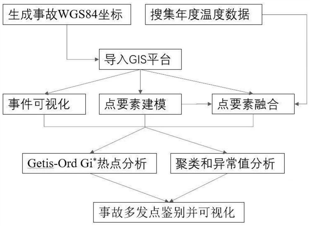
[0037] Such as figure 1 Shown is the flow diagram of the analysis method based on the alarm data point elements to identify the traffic accident frequent points, including the following steps: Step 1. screening traffic accident data, specifically including the following operations: according to the original data of the alarm center at the traffic police end, the original data of the alarm center contains the field information of alarm time, alarm location, alarm type, alarm content, alarm time, approval time, address, ambiguity, level and coordinates. Geographic Information System (GIS) software is used for modeling. This software requires latitude and longitude coordinates. First, the alarm location is converted into latitude and longitude coordinates for geocoding. Geocoding uses the Baidu map coordinate query and conversion tool developed by python. After inputting...


PUM


Abstract

The invention discloses an analysis method for identifying multiple traffic accident points based on alarm data point elements, which comprises the following steps: searching alarm traffic accident data, generating WGS84 coordinates, importing the WGS84 coordinates into a GIS platform, modeling accident point elements, fusing the searched temperature data, identifying multiple regional accident points by adopting Getis-Ord Gi * hotspot analysis, and carrying out clustering analysis on the accidents to obtain an analysis result; carrying out local multi-occurrence point identification through abnormal value analysis and abnormal values around accident multi-occurrence points, and adopting a clustering analysis method of geographic information system (GIS) software, Thiessen polygons, kerneldensity analysis, hot spot analysis and abnormal value analysis. According to the invention, intuitive spatial information about accident distribution can be provided, spatial distribution characteristics of areas with high accident severity are researched, and accident-prone points are identified.

Description

technical field [0001] The invention relates to identification and cause analysis methods of traffic accident multiple points, in particular to an analysis method for identifying traffic accident multiple points based on alarm data point elements. Background technique [0002] At present, there are two main ways to study the spatial distribution characteristics of road traffic accidents: 1. Use traditional statistical methods to make statistics on the data to determine the accident-prone areas; 2. Use Geographic Information System (GIS) technology to map traffic accidents The situation is displayed visually on the map, and then its spatial distribution characteristics are analyzed using the method of spatial analysis. Compared with the first method, the advantages of using GIS for analysis are: (1) the visualization features of GIS can have a more intuitive understanding of the distribution of traffic accidents, so as to quickly form an overall grasp of the traffic safety si...

Claims


Application Information

Patent Timeline
IPC IPC(8): G06T17/05G06K9/62G06F16/29G08G1/01
CPCG06T17/05G06F16/29G08G1/0125G06F18/23
Inventor 廖明军王凯英王杰万骋宇历程曦闻猛
Owner YANCHENG INST OF TECH
Why Eureka
Try Eureka