
Construction method of building map mixed data model for positioning and navigation

A hybrid data, positioning and navigation technology, applied in image data processing, geographic information database, navigation and other directions, can solve the problem that map modeling cannot provide convenience and precision positioning and navigation functions, and modeling cannot have entity display functions at the same time.

Pending Publication Date: 2021-03-09
BEIJING UNIV OF CIVIL ENG & ARCHITECTURE
View PDF7 Cites 6 Cited by
  • Summary
  • Abstract
  • Description
  • Claims
  • Application Information

AI Technical Summary

Problems solved by technology

[0011] The embodiment of the present invention provides a method for constructing a building map hybrid data model for positioning and navigation, which is used to solve the problem that the existing map modeling cannot provide convenient and high-precision positioning and navigation functions, and the modeling cannot have entities at the same time display function problem

Method used


Image

  • Construction method of building map mixed data model for positioning and navigation
  • Construction method of building map mixed data model for positioning and navigation
  • Construction method of building map mixed data model for positioning and navigation

Examples


Embodiment Construction

[0053] In order to make the purpose, technical solutions and advantages of the embodiments of the present invention clearer, the technical solutions in the embodiments of the present invention will be clearly and completely described below in conjunction with the drawings in the embodiments of the present invention. Obviously, the described embodiments It is a part of embodiments of the present invention, but not all embodiments. Based on the embodiments of the present invention, all other embodiments obtained by persons of ordinary skill in the art without making creative efforts belong to the protection scope of the present invention.

[0054] Existing building map modeling generally has the problem that it cannot provide convenient and high-precision positioning and navigation functions, and cannot simultaneously have a three-dimensional entity display function. In this regard, the embodiment of the present invention provides a method for constructing a building map hybrid ...


PUM


Abstract

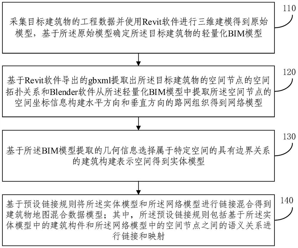
The embodiment of the invention provides a construction method of a building map mixed data model for positioning and navigation. The method comprises the following steps: constructing road network organizations in a horizontal direction and a vertical direction based on a spatial topological relation of spatial nodes of a target building extracted from a lightweight BIM model and spatial coordinate information of each spatial node extracted from the BIM model to obtain a network model; based on geometrical information extracted by the BIM model, selecting a building component representation space which belongs to a specific space and has a boundary relationship to obtain an entity model; performing link mixing on the entity model and the network model based on a preset link rule to obtaina building map mixed data model, wherein the preset link rule comprises link and mapping based on a semantic relationship between a building component in the entity model and a space node in the network model. According to the method provided by the embodiment of the invention, the modeled hybrid data model has an entity display function, and a more convenient and high-precision positioning and navigation function can also be provided.

Description

technical field [0001] The invention relates to the technical field of map model construction, in particular to a method for constructing a building map mixed data model for positioning and navigation. Background technique [0002] The building map is the basis and information carrier of indoor location service applications. The landmarks and context information in the map can be used for indoor positioning error correction and indoor navigation path planning. At present, in the research of building maps, a variety of models have been proposed to construct indoor positioning and navigation, mainly including network model, grid model and entity model. [0003] (1) In the network model, space abstraction is selected as nodes, and the topological relationship between spaces is abstracted as edges. At present, the geometric network model (GNM) based on central axis transformation (MAT) developed from the combined data model (CDM) based on Poincaré duality theory is the most wid...

Claims


Application Information

Patent Timeline
Patent Type & Authority Applications(China)
IPC IPC(8): G06T17/05G06F16/29G01C21/20
CPCG06T17/05G06F16/29G01C21/206
Inventor 刘建华罗竟妍温丹祺冯国强刘大源
Owner BEIJING UNIV OF CIVIL ENG & ARCHITECTURE
Learn More