Rapid surveying and mapping method and device

A fast, surveying and mapping point technology, applied in the field of UAV surveying and mapping, can solve the problems of increasing equipment cost and personnel workload, inability to adapt to fast operations, and low efficiency of manual surveying and mapping

Active Publication Date: 2021-03-12
SUZHOU EAVISION ROBOTIC TECH CO LTD
View PDF8 Cites 8 Cited by
  • Summary
  • Abstract
  • Description
  • Claims
  • Application Information

AI Technical Summary

Problems solved by technology

Among them, the efficiency of manual surveying and mapping is low, and automatic aerial surveying and mapping is not conducive to the use of rapid spraying operations due to the large amount of data and long calculation time, which increases equipment costs and personnel workload.
[0003] Nowadays, before aerial photography surveying and mapping, image control point positioning targets are set in the operation plot for positioning and calibration, so as to improve the mapping accuracy of aerial photography drones. This method needs to determine the positioning target in the field operation plot in advance, and Obtaining complete and accurate positioning information, the efficiency of surveying and mapping is low, and it cannot meet the needs of fast operations

Method used


Image

  • Rapid surveying and mapping method and device
  • Rapid surveying and mapping method and device
  • Rapid surveying and mapping method and device

Examples


Embodiment Construction

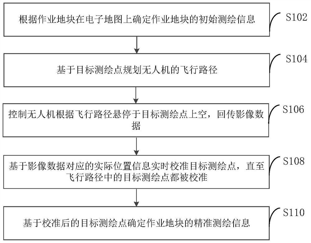
[0043] In order to make the purpose, technical solutions and advantages of the embodiments of the present invention clearer, the technical solutions of the present invention will be clearly and completely described below in conjunction with the accompanying drawings. Obviously, the described embodiments are part of the embodiments of the present invention, not all of them. the embodiment. Based on the embodiments of the present invention, all other embodiments obtained by persons of ordinary skill in the art without making creative efforts belong to the protection scope of the present invention.

[0044] At present, before using UAVs for plant protection operations, manual surveying and mapping and automatic aerial photography surveying and mapping methods can be used to survey and map the work plots.

[0045] Manual surveying and mapping is carried out through carrier phase differential technology (Real-time kinematic, RTK) handheld ground surveying and mapping terminal. User...


PUM


Abstract

The invention provides a rapid surveying and mapping method and device, and belongs to the technical field of unmanned aerial vehicle surveying and mapping. The method comprises the steps that: initial surveying and mapping information of an operation plot on an electronic map is determined according to the operation plot, wherein the initial surveying and mapping information comprises a target surveying and mapping point; a flight path of an unmanned aerial vehicle is planned based on the target surveying and mapping point, wherein the flight path is a path traversing the target surveying andmapping point; the unmanned aerial vehicle is controlled to hover above the target surveying and mapping point according to the flight path, and return image data; the target surveying and mapping point is calibrated in real time based on the actual position information corresponding to the image data until the target surveying and mapping point in the flight path is calibrated; and accurate surveying and mapping information of the operation plot is determined based on the calibrated target surveying and mapping point. The purpose of automatically calibrating the target surveying and mappingpoint in real time is realized the through image data returned by the unmanned aerial vehicle, and therefore, the surveying and mapping efficiency can be improved.

Description

technical field [0001] The invention relates to the technical field of unmanned aerial vehicle surveying and mapping, in particular to a method and device for rapid surveying and mapping. Background technique [0002] Before using drones for spraying, it is generally necessary to survey and map the work area to obtain accurate location information. At present, manual surveying and mapping and automatic aerial surveying and mapping can be used to plan the flight path according to the operation plot. Among them, the efficiency of manual surveying and mapping is low, and automatic aerial surveying and mapping is not conducive to the use of rapid spraying operations due to the large amount of data and long calculation time, which increases equipment costs and personnel workload. [0003] Nowadays, before aerial photography surveying and mapping, image control point positioning targets are set in the work plot for positioning and calibration, so as to improve the surveying and m...

Claims


Application Information

Patent Timeline
Patent Type & Authority Applications(China)
IPC IPC(8): G01C11/04G01S19/43B64D47/08B64C39/02
CPCG01C11/04G01S19/43B64D47/08B64C39/02B64U2101/30
Inventor 董雪松殷熙梅
Owner SUZHOU EAVISION ROBOTIC TECH CO LTD
Why Eureka
Try Eureka