Basic data retrieval and integrated display method based on space-time association of space-time labels

A basic data, space-time correlation technology, applied in the field of data retrieval and spatial information display, can solve serious problems, zoom function failure, high browser pressure, etc., to achieve fast display, good generalization effect, and reduce the number of points.

Pending Publication Date: 2021-03-26
北京国研数通软件技术有限公司
View PDF0 Cites 7 Cited by
  • Summary
  • Abstract
  • Description
  • Claims
  • Application Information

AI Technical Summary

Problems solved by technology

[0007] When a large-scale map is displayed, when the load exceeds a certain amount, the map dragging and

Method used


Image

  • Basic data retrieval and integrated display method based on space-time association of space-time labels
  • Basic data retrieval and integrated display method based on space-time association of space-time labels
  • Basic data retrieval and integrated display method based on space-time association of space-time labels

Examples


Embodiment 1

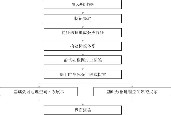
[0045] Such as figure 1 As shown, a basic data retrieval and integrated display method based on spatio-temporal label spatio-temporal association includes the following steps:

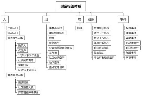
[0046] Step S100: Input basic urban management data such as people, places, objects, organizations, and events;

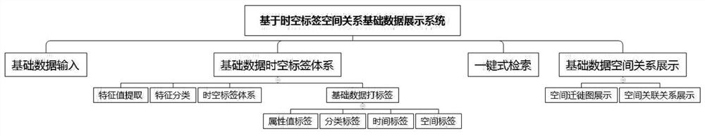
[0047] Step S200: Based on the basic data subject data table definition and data entity field information, extract its entity features and attribute features, spatial geographic location features, time features, and inter-entity relationship features;

[0048] Step S300: Organize the features of the above step S200, assist manual selection to form basic data classification features such as people, places, objects, organizations, events, etc., and then form a space-time classification label system;

[0049]Step S400: First, sample and clean the basic data, use category mapping rules, abstract the cleaning process into business rules, perform rule cleaning, perform global cleaning and iterat...


PUM


Abstract

The invention discloses a basic data retrieval and integrated display method based on spatio-temporal label spatio-temporal association. The method comprises the steps of performing spatio-temporal labeling on basic data; establishing an association relationship between the labels; retrieving basic data in a one-key mode based on space-time labels and the like. The invention has the advantages that people, ground, objects, organizations and events in smart city management are subjected to tagging classification, the logic relation between data is constructed, the spatial relation and the movement track relation between related elements are visually displayed through a map, and the smart city is effectively supported to perform full-life-cycle management on a target.

Description

technical field [0001] The invention relates to a data retrieval and spatial information display method, in particular to a basic data retrieval and integrated display method based on spatio-temporal tag spatio-temporal association, which belongs to the field of data retrieval and spatial information display. Background technique [0002] In the field of smart city management business, it is necessary to conduct real-time supervision of various components, people, buildings, events, and legal entities in city management. In the existing technology, basic data queries such as people, parts, buildings, events, and legal entities are supported and displayed on the map based on coordinate labeling. Data association query display is slow, and large-scale data map display is not supported. Therefore, it is the key to technology and development to establish spatio-temporal labels on the basic data model, obtain the spatio-temporal relationship of basic data, retrieve based on spati...

Claims


Application Information

Patent Timeline
IPC IPC(8): G06F16/9537G06F16/248G06F16/28G06F16/29G06F16/2455G06F16/215G06F16/35G06F40/284G06N3/04
CPCG06F16/9537G06F16/248G06F16/288G06F16/29G06F16/24564G06F16/215G06F16/355G06F40/284G06N3/045
Inventor 张晓军钱双丁勇张德健岳刚
Owner 北京国研数通软件技术有限公司
Why Eureka
Try Eureka