Digital twin city space positioning method and device based on unreal engine, and storage medium

An Unreal Engine, spatial positioning technology, applied in special data processing applications, geometric CAD, etc., can solve the problems of complex internal structure, high resource occupation, low digital twin efficiency, etc., to achieve the effect of saving resource occupancy and variable precision

Pending Publication Date: 2021-04-09
SUZHOU MAIN GOAL SOFTWARE TECH CO LTD
View PDF0 Cites 12 Cited by
  • Summary
  • Abstract
  • Description
  • Claims
  • Application Information

AI Technical Summary

Benefits of technology

In this new way for creators that want their location data faster at any time, it's possible to use an Unrepresentated Digital Twina (UD) technique called Dual City Spatial Positioning System (DSPS). Compared with previous methods like Ground Penetrating Radar (GPR), these techniques save up 90 per cent -75% while also reducing labor costs associated with constructing physical models within them. Additionally, they provide quicker response times when used indoors due to less complex calculations needed. Overall, this approach allows companies to better manage assets efficiently without having to invest large amounts of money into infrastructure projects.

Problems solved by technology

This patented describes how digital twinas work well with existing techniques such as simulators or computer simulations (CST). While some progresses were made towards developing new ways to create high fidelity environments like those found during games, they still face challenges related to their ability to accurately represent reality without requiring human intervention. Current solutions require expensive equipment and complicated infrastructure, which makes them difficult to use beyond just playing simulation rather than actual experience. Therefore, researchers aim to develop a solution that overcomes these issues while maintains accuracy.

Method used


Image

  • Digital twin city space positioning method and device based on unreal engine, and storage medium
  • Digital twin city space positioning method and device based on unreal engine, and storage medium

Examples


Embodiment Construction

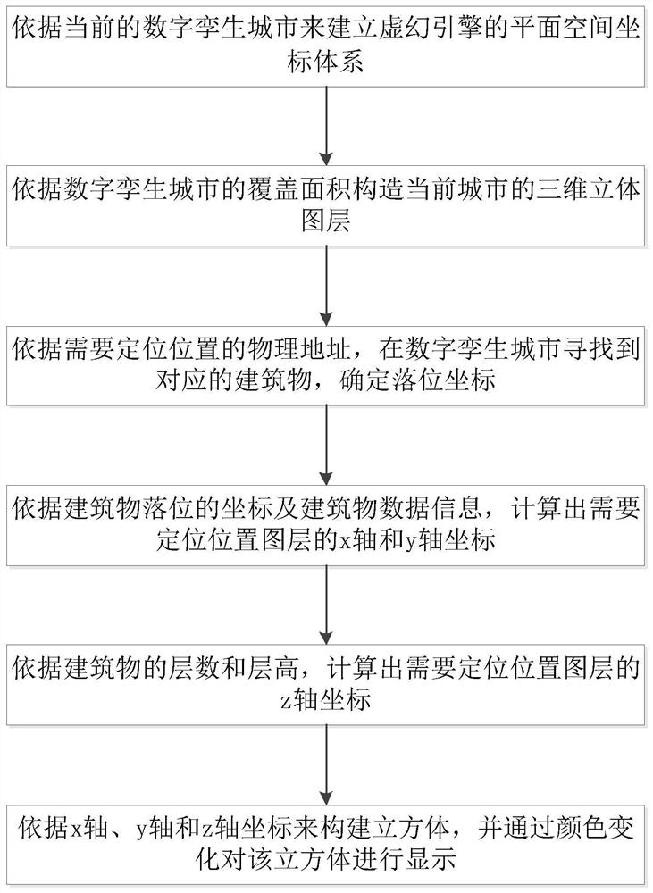
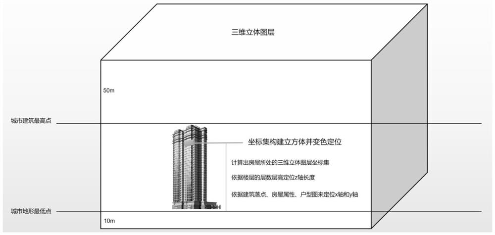
[0021] The implementation of the present invention is illustrated by specific specific examples below, and those skilled in the art can easily understand other advantages and effects of the present invention from the content disclosed in this specification.

[0022] Example embodiments will now be described more fully with reference to the accompanying drawings. Example embodiments may, however, be embodied in many forms and should not be construed as limited to the examples set forth herein; rather, these embodiments are provided so that this disclosure will be thorough and complete and fully convey the concept of example embodiments to those skilled in the art. The described features, structures, or characteristics may be combined in any suitable manner in one or more embodiments. In the following description, numerous specific details are provided in order to give a thorough understanding of embodiments of the invention. However, those skilled in the art will appreciate t...


PUM


Abstract

The invention discloses a digital city space positioning method based on an unreal engine. The method comprises the following steps: constructing a three-dimensional layer of a current city, determining the coordinates of a building located in a plane space coordinate system of the unreal engine, calculating the x-axis, y-axis and z-axis coordinates of a to-be-positioned layer, constructing a cube according to x-axis, y-axis and z-axis coordinates, and displaying the cube through color change. Compared with a traditional GIS digital twinning technology, the digital twinning city space positioning method based on the unreal engine has the advantages that a real three-dimensional space is realized; and compared with an algorithm of a BIM system, model construction does not need to be carried out on the interior of the building model, the twin city resource occupancy rate is saved by 70% or above, the twin city construction workload is reduced by 60%, and the positioning method is rapid to implement, variable in precision and capable of changing the precision at will according to different city scenes of technical application.

Description


Claims


Application Information

Patent Timeline
Owner SUZHOU MAIN GOAL SOFTWARE TECH CO LTD
Why Eureka
Try Eureka