
A method of image enhancement processing for UAV remote sensing surveying and mapping

An image enhancement and processing method technology, applied in the field of image processing, can solve problems such as poor enhancement effect

Active Publication Date: 2022-07-19
浙江明州测绘院
View PDF5 Cites 0 Cited by
  • Summary
  • Abstract
  • Description
  • Claims
  • Application Information

AI Technical Summary

Problems solved by technology

In the prior art, the enhancement processing of remote sensing images is generally global enhancement processing, and the enhancement effect is not good

Method used


Image

  • A method of image enhancement processing for UAV remote sensing surveying and mapping
  • A method of image enhancement processing for UAV remote sensing surveying and mapping
  • A method of image enhancement processing for UAV remote sensing surveying and mapping

Examples


Embodiment Construction

[0013] The following describes in detail the embodiments of the present invention, examples of which are illustrated in the accompanying drawings, wherein the same or similar reference numerals refer to the same or similar elements or elements having the same or similar functions throughout. The embodiments described below with reference to the accompanying drawings are exemplary and are only used to explain the present invention, and should not be construed as a limitation of the present invention.

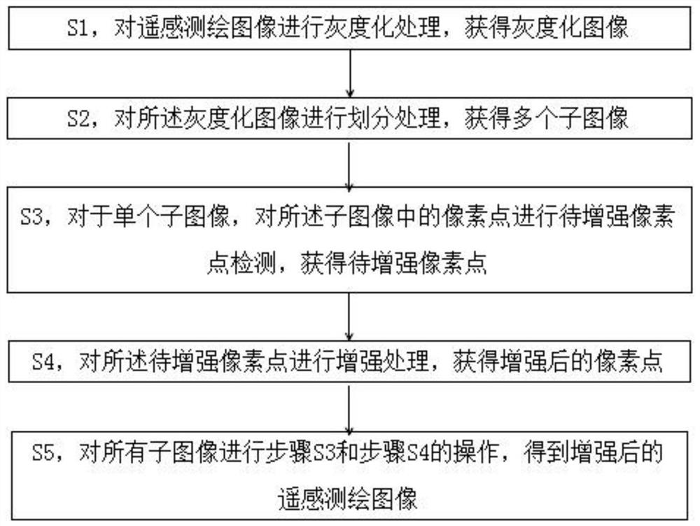
[0014] like figure 1 As shown in the embodiments in the present invention, the present invention provides a method for enhancing remote sensing surveying and mapping images of unmanned aerial vehicles, which includes:

[0015] S1, performing grayscale processing on the remote sensing mapping image to obtain a grayscale image;

[0016] S2, dividing the grayscale image to obtain multiple sub-images;

[0017] S3, for a single sub-image, perform pixel point detection to be enhanced...


PUM


Abstract

The present invention provides an enhanced processing method for remote sensing surveying and mapping images of unmanned aerial vehicles, which includes S1, performing grayscale processing on the remote sensing surveying and mapping images to obtain grayscale images; S2, performing division processing on the grayscale images to obtain A plurality of sub-images; S3, for a single sub-image, perform pixel point detection to be enhanced on the pixel points in the sub-image to obtain the pixel to be enhanced; S4, perform enhancement processing on the pixel to be enhanced to obtain an enhanced pixel point pixel point; S5, performing the operations of step S3 and step S4 on all sub-images to obtain an enhanced remote sensing mapping image. By screening the pixels that need to be enhanced, the present invention avoids the phenomenon of excessive enhancement of pixels that occurs when all pixels are enhanced in the traditional image enhancement method. Excessive enhancement can easily turn normal pixels into noise.

Description

technical field [0001] The invention relates to the field of image processing, in particular to an enhanced processing method for remote sensing surveying and mapping images of unmanned aerial vehicles. Background technique [0002] UAV remote sensing mapping, that is, using advanced unmanned aerial vehicle technology, remote sensing sensor technology, telemetry and remote control technology, communication technology, GPS differential positioning technology and remote sensing application technology, it can realize automatic, intelligent and specialized rapid acquisition of land resources, Spatial remote sensing mapping images of natural environment, earthquake disaster areas, etc. After the remote sensing mapping image is obtained, it generally needs to be enhanced. In the prior art, the enhancement processing for remote sensing images is generally global enhancement processing, and the enhancement effect is not good. SUMMARY OF THE INVENTION [0003] In view of the abov...

Claims


Application Information

Patent Timeline
Patent Type & Authority Patents(China)
IPC IPC(8): G06T5/00G06T7/00
CPCG06T5/001G06T7/0002G06T2207/10032G06T2207/10024
Inventor 朱旭红周佳玮陈洪建陈科明
Owner 浙江明州测绘院
Learn More