Spatial calibration method and system

A calibration method and space technology, applied in the field of space calibration methods and systems, can solve problems such as large calibration error and inability to guarantee calibration accuracy.

Pending Publication Date: 2021-06-11
HUAWEI TECH CO LTD
View PDF0 Cites 8 Cited by
  • Summary
  • Abstract
  • Description
  • Claims
  • Application Information

AI Technical Summary

Problems solved by technology

Using this spatial calibration technical solution for spatial calibration, it is necessary to ensure that the geographical area is close to the planar distribution. However, in practical application scenarios, the geographical area generally cannot meet the planarity requirements, that is, the surface of the geographical area is not flat. Therefore, using the existing Some spatial calibration technical solutions for spatial calibration will not be able to guarantee the calibration accuracy, resulting in large calibration errors

Method used


Image

  • Spatial calibration method and system
  • Spatial calibration method and system
  • Spatial calibration method and system

Examples


Embodiment Construction

[0040] The technical solutions in the embodiments of the present application will be clearly and completely described below in conjunction with the accompanying drawings. Apparently, the described embodiments are only some of the embodiments of the present application, not all of them.

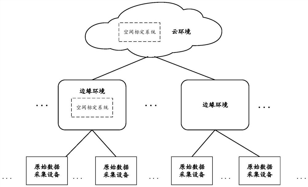
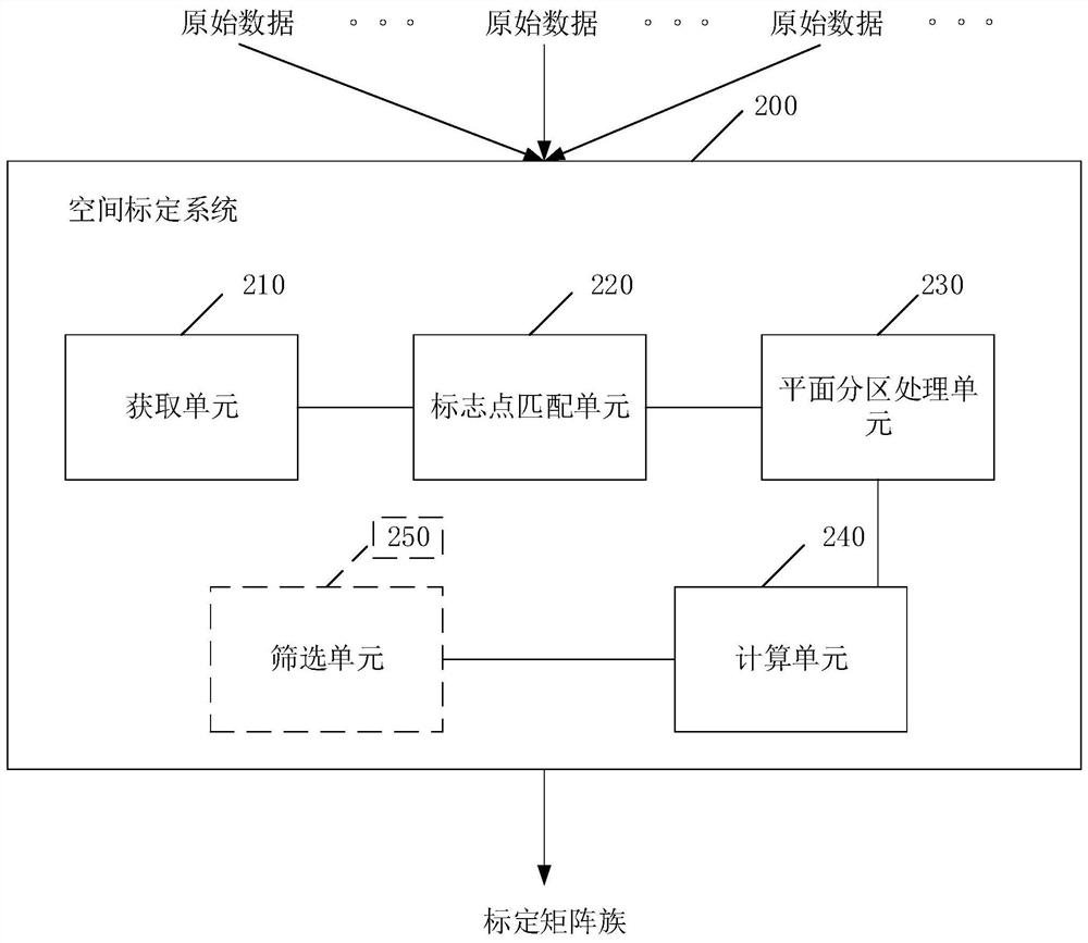
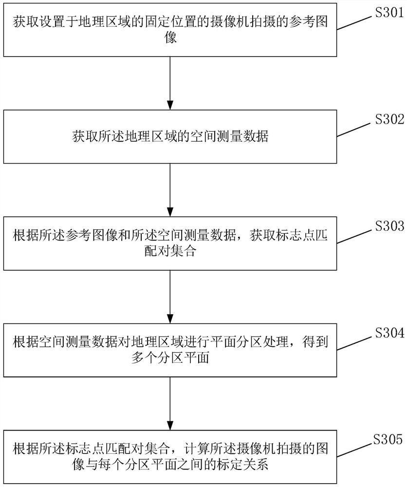
[0041] Geographical area is a specific area in the physical world, such as areas such as traffic intersections, traffic roads, and residential gates. The present application provides a spatial calibration method, which is executed by a spatial calibration system, and the spatial calibration of a camera can be realized through the spatial calibration method. Specifically, the spatial calibration is: calculating the corresponding relationship between the pixel coordinates of a point in the image corresponding to a geographic area and the corresponding geographic coordinates of the point, and this corresponding relationship is also called a calibration relationship. The image corresponding to the...


PUM


Abstract

The invention provides a space calibration method and system. The method comprises the following steps: collecting a reference image shot by a camera and spatial measurement data of a geographic area; carrying out plane partitioning processing on the geographic area according to the spatial measurement data to obtain a plurality of partitioning planes; according to the reference image and the spatial measurement data, a mark point matching pair set is obtained, and each mark point matching pair in the mark point matching pair set comprises geographic coordinates of a mark point in the geographic area and pixel coordinates of the mark point in the image; According to the mark point matching pair set, calculating a calibration relationship between an image shot by a camera and each partition plane, and obtaining a calibration matrix family between the image shot by the camera and the geographic area. The method can improve the space calibration precision and expand the application scene.

Description

technical field [0001] The present application relates to the field of artificial intelligence (AI), in particular to a space calibration method and system. Background technique [0002] At present, a large number of cameras are deployed in various areas of the city for real-time monitoring. For example, cameras are deployed at urban traffic intersections to monitor traffic information such as traffic flow and people flow at traffic intersections in real time. And with the development of artificial intelligence technology, face recognition, license plate recognition, vehicle model recognition and other technologies have been widely used in automatic monitoring of traffic intersections, which greatly improves the efficiency of traffic supervision and ensures the safety and order of urban traffic. In order to monitor and analyze the traffic status of traffic intersections, such as monitoring the position of vehicles and pedestrians at traffic intersections, the running speed ...

Claims


Application Information

Patent Timeline
Patent Type & Authority Applications(China)
IPC IPC(8): G06T7/80G06T7/30
CPCG06T7/30G06T7/80
Inventor 杨少鹏王杰马春飞王工艺
Owner HUAWEI TECH CO LTD
Why Eureka
Try Eureka