A method for extracting urban built-up areas by fusing nighttime light data and landsat8 OLI images

A technology for nighttime lighting and extraction methods, which is applied to instruments, calculations, character and pattern recognition, etc. It can solve the problems of confusion between water bodies and urban built-up areas, and the accuracy cannot meet the extraction requirements, so as to reduce spillover effects and improve accuracy.

Active Publication Date: 2022-04-15
WUHAN UNIV
View PDF3 Cites 0 Cited by
  • Summary
  • Abstract
  • Description
  • Claims
  • Application Information

AI Technical Summary

Problems solved by technology

[0004] In view of the shortcomings of VANUI, especially its confusion of water bodies and urban built-up areas, its accuracy cannot meet the higher-precision urban built-up area extraction requirements

Method used


Image

  • A method for extracting urban built-up areas by fusing nighttime light data and landsat8 OLI images
  • A method for extracting urban built-up areas by fusing nighttime light data and landsat8 OLI images
  • A method for extracting urban built-up areas by fusing nighttime light data and landsat8 OLI images

Examples


Embodiment Construction

[0032] The present invention will be further described in conjunction with the accompanying drawings and specific embodiments.

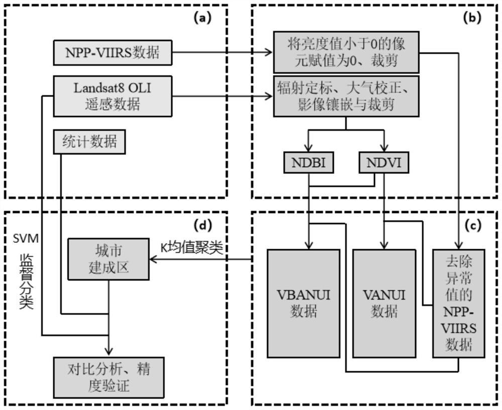
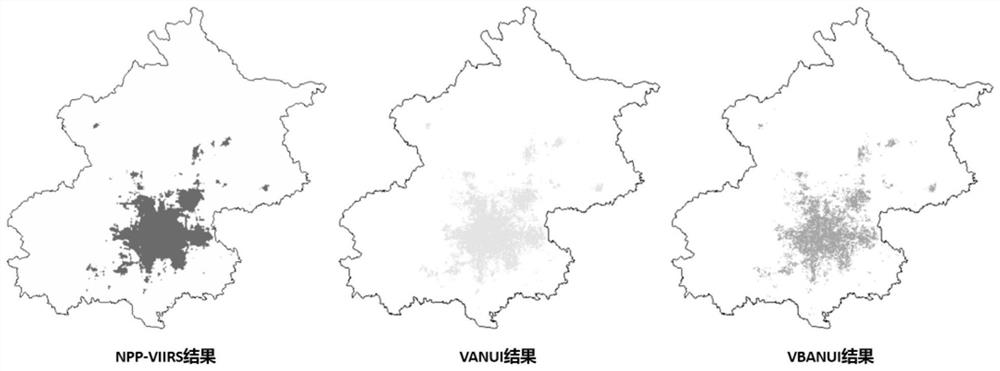
[0033] Such as figure 1 As shown, the present invention proposes a method for extracting urban built-up areas that fuses NPP-VIIRS night light data and Landsat8 OLI images, extracts index data such as NDVI and NDBI, and creatively proposes an urban night light index (Vegetation Index) based on vegetation and building correction. and Building Adjusted NTL Urban Index, VBANUI). The calculation formula of VBANUI is as follows:

[0034] VBANUI = (1-NDVI)·(1+NDBI)·NTL (1)

[0035]

[0036]

[0037] Among them, B5 is the reflectance of the fifth band (near-infrared band) of Landsat8 OLI; B4 is the reflectance of the fourth band (red band) of Landsat8 OLI; B6 is the reflectance of the sixth band (mid-infrared band) of Landsat8 OLI. NTL is NPP-VIIRS night light data. NDVI is the normalized difference vegetation index, and NDBI is the normalized dif...


PUM


Abstract

The invention discloses a method for extracting urban built-up areas by fusing NPP-VIIRS night light data and Landsat8OLI images, which may include the following steps: 1. Obtain the city's NPP-VIIRS night light data and Landsat8OLI image spectrum data, and analyze NPP-VIIRS VIIRS night light data and Landsat8OLI data are preprocessed. 2. Extract NDVI and NDBI from Landsat8OLI data, where NDVI is the normalized difference vegetation index and NDBI is the normalized difference building index. 3. Use VBANUI (improved night light city index method) to extract urban built-up areas. The present invention can reduce the saturation phenomenon of luminous data in the urban core area by introducing the two indexes of NDVI and NDBI, and can remove the light overflow phenomenon of the night light brightness in the vegetation area of ​​the water body and the urban core area, and enhance the expression of building information. Improved the accuracy of urban built-up area extraction.

Description

technical field [0001] The invention relates to a method for extracting urban built-up areas by fusing NPP-VIIRS night light data and Landsat8 OLI images. Background technique [0002] Under the current background, there are mainly two ways to obtain data on built-up areas. One is based on the socio-economic statistics of administrative units. The defect of this method is the lack of sufficient spatial information in the socio-economic statistics; the other is based on medium and high-resolution remote sensing data represented by Landsat. This method The disadvantage is that medium and high-resolution remote sensing data are limited by their geographical coverage, and the large-scale urban agglomerations and national regions require a lot of time and labor costs, which are not suitable for inversion of changes in urban built-up areas. Therefore, using the above method for large-scale built-up area statistics requires a lot of manpower and material resources, and it is diffi...

Claims


Application Information

Patent Timeline
Patent Type & Authority Patents(China)
IPC IPC(8): G06V20/10G06V10/40G06V10/762G06V10/774G06V10/80G06K9/62
CPCG06V20/176G06V10/40G06F18/23213G06F18/2411G06F18/253
Inventor 胡庆武张寅艾明耀赵鹏程顾淼
Owner WUHAN UNIV
Why Eureka
Try Eureka