Anti-collision self-cooling surveying and mapping unmanned aerial vehicle capable of adjusting photographing angle according to flight speed

A technology of flight speed and self-heating, applied in the field of surveying and mapping, it can solve the problems of no camera protection, no camera adjustment function, inconvenient anti-collision and anti-winding, etc., to effectively cover and prevent damage.

Pending Publication Date: 2021-08-20
ANHUI SCI & TECH UNIV
View PDF13 Cites 3 Cited by
  • Summary
  • Abstract
  • Description
  • Claims
  • Application Information

AI Technical Summary

Problems solved by technology

[0007] The purpose of the present invention is to provide an anti-collision self-heating surveying and mapping UAV that adjusts the camera angle according to the flight speed, so as to solve the problem that the above-mentioned background technology does not have the function of adjusting the angle of the camera according to the flight speed; Self-heating; it is inconvenient to achieve an anti-collision and anti-winding function during the flight; the problem of not being able to protect the camera after landing

Method used


Image

  • Anti-collision self-cooling surveying and mapping unmanned aerial vehicle capable of adjusting photographing angle according to flight speed
  • Anti-collision self-cooling surveying and mapping unmanned aerial vehicle capable of adjusting photographing angle according to flight speed
  • Anti-collision self-cooling surveying and mapping unmanned aerial vehicle capable of adjusting photographing angle according to flight speed

Examples


Embodiment Construction

[0037] Next, the technical solutions in the embodiments of the present invention will be apparent from the embodiment of the present invention, and it is clearly described, and it is understood that the described embodiments are merely embodiments of the present invention, not all of the embodiments. Based on the embodiments of the present invention, there are all other embodiments obtained without making creative labor without making creative labor premises.

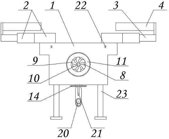
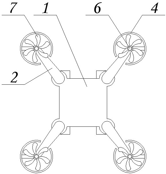
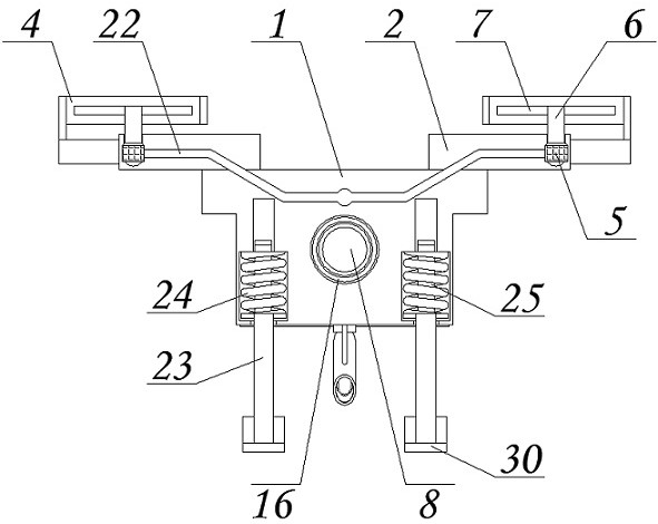
[0038] See Figure 1-6The present invention provides a technical solution: a non-collision self-refining method according to a flight speed adjustment photographic drone, including a body 1, a support plate 2, a support rod 3, a protective ring 4, a flight motor 5, a drive shaft 6 , Flying fan blade 7, inlet air hole 8, into the air leaf 9, fixed shaft 10, first tapered gear 11, the second tapered gear 12, support column 13, cutting sheet 14, spindle cloth 15, circle block 16, the reset spring 17, the guide rod 18, the push ...


PUM


Abstract

The invention provides an anti-collision self-cooling surveying and mapping unmanned aerial vehicle capable of adjusting the photographing angle according to the flight speed. The unmanned aerial vehicle comprises a vehicle body, the vehicle body is a main shell of the unmanned aerial vehicle, and a supporting plate is fixedly arranged at the top of the vehicle body; a flying motor is fixedly arranged in the supporting plate, a driving shaft is installed at the output end of the flying motor, and flying fan blades are fixedly connected to the outer surface of the top end of the driving shaft; an air inlet hole is formed in the surface of one side of the vehicle body, and the bottom surface of the vehicle body is connected with a surveying and mapping camera. According to the anti-collision self-heat-dissipation surveying and mapping unmanned aerial vehicle capable of adjusting the photographing angle according to the flight speed, in the flight process, the wind power is gradually increased, so that the force borne by the wind blocking cloth is very large, the wind blocking cloth drives a circular ring block to move, the circular ring block can push a push block through a guide rod, the push block is driven to push the surveying and mapping camera to rotate through a limiting rod, so that the effect of adjusting the angle according to the wind speed is achieved.

Description

Technical field [0001] The present invention relates to the field of surveying and mapping, in particular, a non-collision self-refining detection drone according to a flight speed adjustment photographic angle. Background technique [0002] Surveying is a technique based on space, geography and information, etc., which is generally called so-called measurement and drawing, etc., and the surveylation will pass many ways, such as using the mappurator and flight drone, etc., The measuring flight drone is flying in the sky through the drone, and the image recorded by the camera, thereby performing a mapping, and can effectively reflect the graphics and location information of the ground status, but the mapping is not available. Human machine has some shortcomings: [0003] First, the mapping drone is in the flight, and its camera is mainly used to observe the front flight route, and this requires no adjustment of the photographic angle, which is very troublesome, and does not have t...

Claims


Application Information

Patent Timeline
Patent Type & Authority Applications(China)
IPC IPC(8): B64C39/02B64D47/08B64D33/10
CPCB64C39/024B64D47/08B64D33/10B64U10/10
Inventor 张官进权玲袁平宋梓杰周子文王伟强蒋浩曹鹏刘彪贾志强
Owner ANHUI SCI & TECH UNIV
Why Eureka
Try Eureka