Air-ground unmanned system reconnaissance cooperative path planning method based on task priority

A task priority and path planning technology, applied in the field of unmanned system navigation, can solve the problems of not considering priority reconnaissance, low endurance of small UAVs, etc., and achieve the effect of solving insufficient endurance.

Active Publication Date: 2021-10-26
NANJING UNIV OF SCI & TECH
View PDF7 Cites 4 Cited by
  • Summary
  • Abstract
  • Description
  • Claims
  • Application Information

AI Technical Summary

Problems solved by technology

[0003] The existing patent CN 111811529 A proposes a multi-region vehicle-machine cooperative reconnaissance path planning method and system. This patent takes into account the problem of low battery life of small UAVs , introducing automobiles as the mobile platform of UAVs, and constructing a vehicle-machine collaborative battlefield reconnaissance system, so as to realize multi-area reconnaissance, but this method is only for the situation of one vehicle and one machine, and does not consider some actual reconnaissance Areas that require priority scouting

Method used


Image

  • Air-ground unmanned system reconnaissance cooperative path planning method based on task priority
  • Air-ground unmanned system reconnaissance cooperative path planning method based on task priority
  • Air-ground unmanned system reconnaissance cooperative path planning method based on task priority

Examples


Embodiment

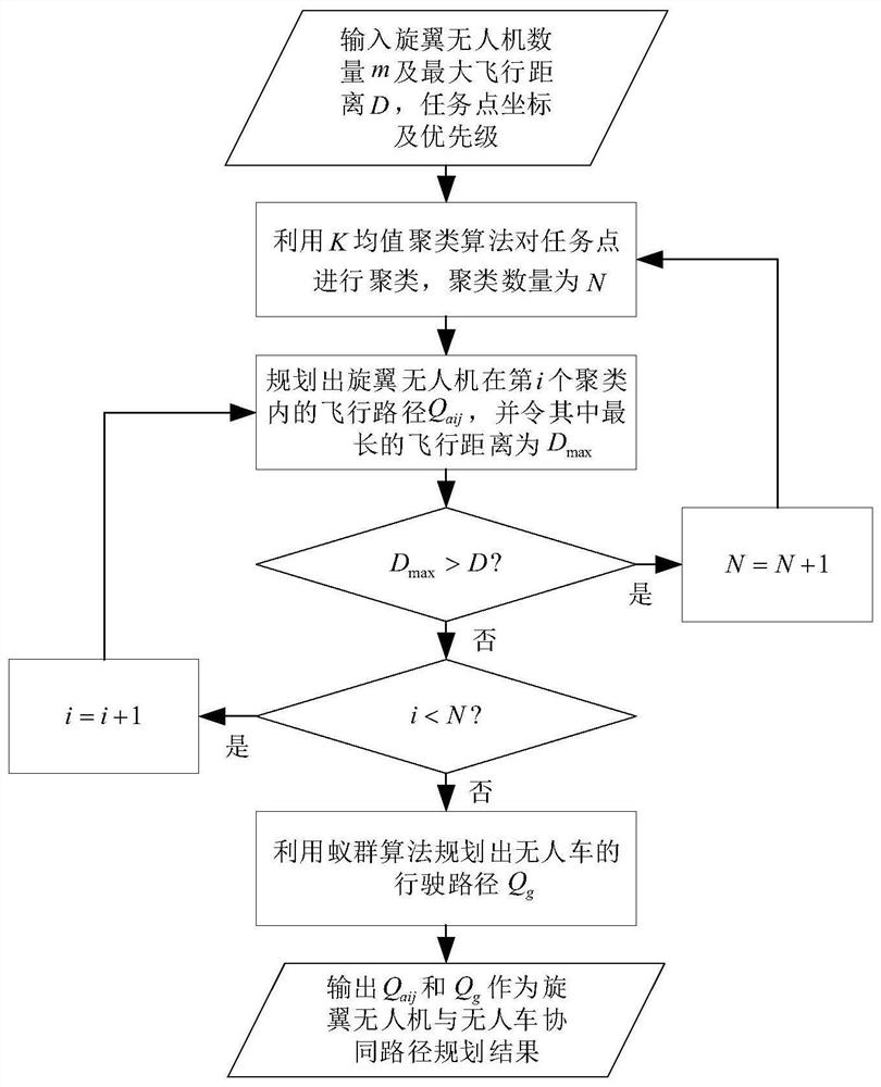
[0030] In order to explain the effectiveness of the algorithm of the present invention, it is possible to fully demonstrate the function of synergistic path planning, and the experiment is as follows:

[0031] (1) Experimental initial conditions and parameter settings

[0032] 50 task points were scattered in the region of 6000m × 6000m, and the priority of the task point was divided into 3 categories: very urgent, urgent and unstimed, replaced with numbers 3, 2, 1 in turn. The number of rotor drones n = 4, the maximum flight distance D = 10000m.

[0033] (2) Analysis of experiment

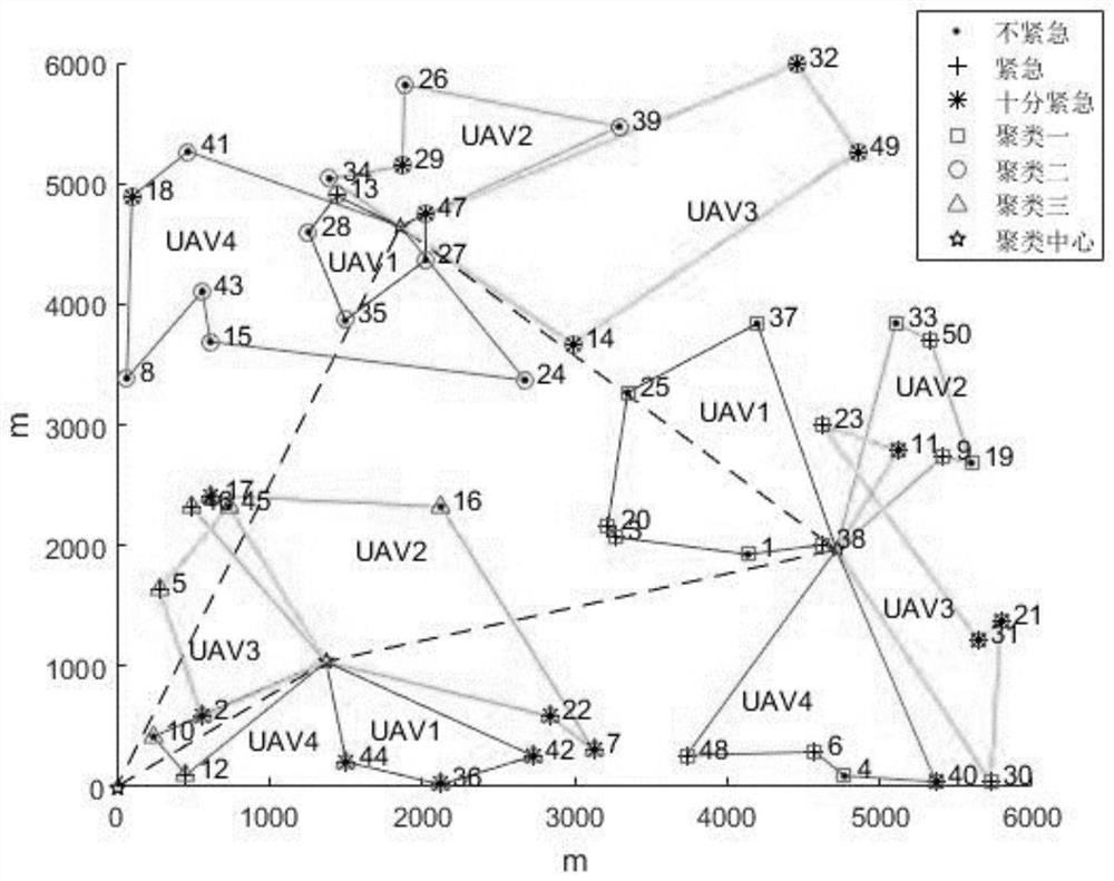
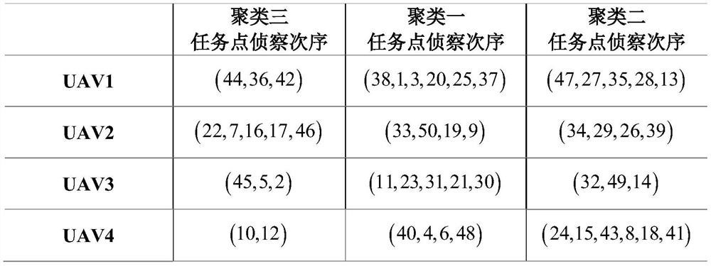
[0034] figure 2 The path simulation chart of the rotorial discharge group and the drone in this method. The digital representative task point number, Pentagar represents each clustering center, the asterisk representative is very urgent task point, the plus sign represents an urgent task point, solid point represents an unexpected task point, square, round And the triangle represents clustering, clus...


PUM


Abstract

The invention discloses an air-ground unmanned system reconnaissance cooperative path planning method based on task priority, and the method comprises the steps: introducing an unmanned vehicle as a mobile charging station of a rotor unmanned aerial vehicle cluster for the conditions that the cruising ability of a rotor unmanned aerial vehicle is limited, the priorities of task points are different in practical application, and the like; firstly, clustering task points by using a K-means clustering algorithm, then setting a target function needing to be optimized to be the sum of the product of the priority of each task point and the reconnaissance sequence of each task point, planning the flight path of a rotor unmanned aerial vehicle cluster in each cluster by using an ant colony algorithm, and finally, planning a driving path of the unmanned vehicle among the clusters by using an ant colony algorithm. The method has the advantages that (1) the unmanned vehicle is used for charging the rotor unmanned aerial vehicle cluster, so that the problem of insufficient endurance of the rotor unmanned aerial vehicle is effectively solved; and (2) a reconnaissance sequence is planned according to task priorities. According to the method, the path planning of the vehicle-mounted rotor unmanned aerial vehicle cluster system can be realized according to the importance degree of multiple task points in a large-range region.

Description

Technical field [0001] The present invention belongs to the field of unmanned system navigation technology, and is specifically a method for detecting a synergistic path planning method based on a navigation-priority. Background technique [0002] When using the unmanned platform, considering that the rotor drone's field of view is large but the endurance capacity is limited, no one has no endurance, but the reconnaissance perspective is limited, and the use of rotor drone and unmanned car collaborative reconnaissance can be efficient mission accomplished. At present, most of the research is for the fastest completion of the reconnaissance task, however, in actual conditions, some task points may require priority to reconnaissance, then the path of the unattended platform needs to be reasonably planned according to the urgency of the task point. [0003] The existing patent CN 111811529 A proposes a multi-regional car coordinating reconnaissance path planning method and system, w...

Claims


Application Information

Patent Timeline
Patent Type & Authority Applications(China)
IPC IPC(8): G05D1/10
CPCG05D1/101Y02T10/70
Inventor 赵高鹏饶玉婷李学文周乾君谷穗斌
Owner NANJING UNIV OF SCI & TECH
Why Eureka
Try Eureka