Semantic segmentation method and system for removing dynamic objects

A semantic segmentation and object technology, applied in neural learning methods, image analysis, biological neural network models, etc., can solve environmental positioning and map construction errors, low precision and stability of three-dimensional positioning and mapping, and cannot meet dynamic and complex Environmental positioning and mapping requirements, etc., to achieve reliable results in dynamic environments

Active Publication Date: 2021-10-29
SHANDONG UNIV +1
View PDF4 Cites 4 Cited by
  • Summary
  • Abstract
  • Description
  • Claims
  • Application Information

AI Technical Summary

Problems solved by technology

[0003] Simultaneous Localization and Mapping (SLAM) technology of robots has been widely used in high-precision map collection, unmanned positioning, AGV, AR / VR, drones and other fields. However, in complex scenarios (such as: In mining scenarios), dynamic objects will cause false associations between observations and maps, which will interfere with the point cloud information obtained by radar, resulting in large errors in environment positioning and map construction; deep learning can obtain dense semantic information of laser point cloud data and It is trained and classified, but it can only achieve high-precision positioning and mapping at the two-dimensional level, and the accuracy and stability of positioning and mapping at the three-dimensional level are low
Therefore, the deep learning technology of single laser SLAM and 3D point cloud cannot meet the positioning and mapping requirements of dynamic and complex environments

Method used


Image

  • Semantic segmentation method and system for removing dynamic objects
  • Semantic segmentation method and system for removing dynamic objects
  • Semantic segmentation method and system for removing dynamic objects

Examples


Embodiment 1

[0042] This embodiment provides a semantic segmentation method for removing dynamic objects, which specifically includes the following steps:

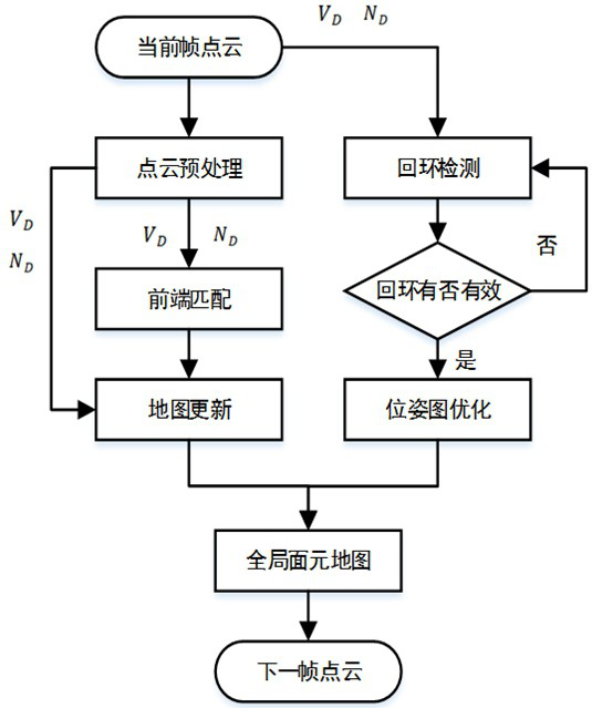
[0043] Step 1: Obtain the 3D point cloud of the scene and project it into a 2D depth map, calculate the normal vector information of the point cloud, and construct a surfel map with loop closure.

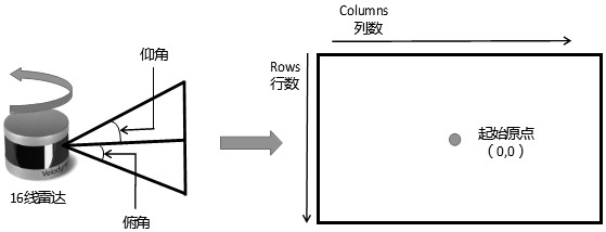
[0044] In a specific embodiment, a 16-line lidar is used to acquire 2D depth map and normal vector information.

[0045] It can be understood here that in other embodiments, laser radars with other numbers of lines can also be used to obtain 2D depth maps and normal vector information, and those skilled in the art can make specific choices according to actual conditions, and will not repeat them here. .

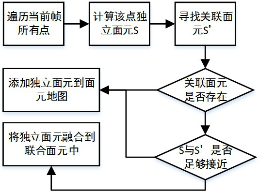
[0046] Among them, the facet map construction flow chart is as follows figure 2 shown in figure 2 middle, V D Represents a 2D depth map, N D Representation vector information. Specifically, the specific process of step 1 includes:...

Embodiment 2

[0088] This embodiment provides a semantic segmentation system for removing dynamic objects, which specifically includes the following modules:

[0089] A surfel structure map building module, which is used to obtain the 3D point cloud of the scene and project it into a 2D depth map, calculate the normal vector information of the point cloud, and construct a surfel map with loops;

[0090] Semantic point cloud map building module, which is used to carry out point cloud semantic segmentation on surface element maps with loopbacks, construct semantic point cloud maps, map semantic point cloud maps into 3D point cloud maps and remove edge shadows and Point cloud discretization phenomenon;

[0091] The semantic point cloud map optimization module is used to remove dynamic objects by using the semantic point cloud information in the semantic point cloud map, and add semantic iteration closest point constraints to obtain the optimized semantic point cloud map.

[0092] Wherein, in ...


PUM


Abstract

The invention belongs to the field of image processing, and provides a semantic segmentation method and system for removing dynamic objects. The semantic segmentation method comprises the following steps: acquiring a scene 3D point cloud, projecting the scene 3D point cloud into a 2D depth map, calculating normal vector information of the point cloud, and constructing a surface element map with a loop; carrying out point cloud semantic segmentation on the surface element map with the loop, constructing a semantic point cloud map, mapping the semantic point cloud map to a 3D point cloud map, and removing edge shadows and point cloud discretization phenomena; and removing the dynamic object by utilizing semantic point cloud information in the semantic point cloud map, and adding semantic iteration nearest point constraint to obtain an optimized semantic point cloud map.

Description

technical field [0001] The invention belongs to the field of image data processing, in particular to a semantic segmentation method and system for removing dynamic objects. Background technique [0002] The statements in this section merely provide background information related to the present invention and do not necessarily constitute prior art. [0003] Simultaneous Localization and Mapping (SLAM) technology of robots has been widely used in high-precision map collection, unmanned positioning, AGV, AR / VR, drones and other fields. However, in complex scenarios (such as: In the mining scene), dynamic objects will cause false associations between observations and maps, which will interfere with the point cloud information obtained by radar, resulting in large errors in environment positioning and map construction; deep learning can obtain dense semantic information of laser point cloud data and It is trained and classified, but it can only achieve high-precision positioning...

Claims


Application Information

Patent Timeline
Patent Type & Authority Applications(China)
IPC IPC(8): G06T7/12G06T7/13G06T7/73G06N3/04G06N3/08
CPCG06T7/12G06T7/13G06T7/75G06N3/04G06N3/08G06T2207/10028G06T2207/20081G06T2207/20084
Inventor 皇攀凌李留昭赵一凡周军林乐彬欧金顺高新彪孟广辉
Owner SHANDONG UNIV
Why Eureka
Try Eureka