Territorial space planning method

A space planning and space technology, applied in the direction of instruments, character and pattern recognition, data processing applications, etc., can solve the problems of long cycle, complex approval process, overlapping and conflicting planning types and content, and achieve the effect of ensuring rationality

Pending Publication Date: 2021-11-02
LANZHOU JIAOTONG UNIV
View PDF0 Cites 1 Cited by
  • Summary
  • Abstract
  • Description
  • Claims
  • Application Information

AI Technical Summary

Problems solved by technology

[0003] For a long time, there have been many problems in the process of land and space planning, such as too many planning types, overlapping and conflicting contents, complicated approval process, long cycle, and local planning changes. Establish a land and space planning system and supervise its implementation. It is imminent to realize "multi-plan integration" by integrating planning, urban and rural planning and other spatial planning into a unified national land space planning.

Method used


Image

  • Territorial space planning method
  • Territorial space planning method

Examples


Embodiment 2

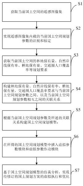
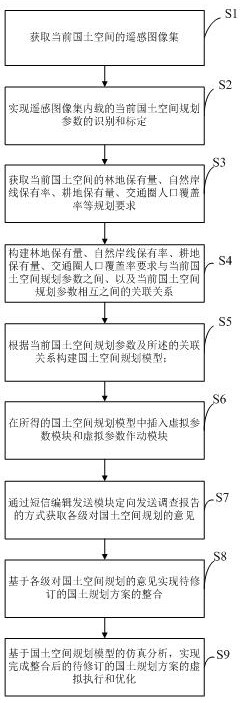
[0038] Such as figure 2 As shown, the embodiment of the present invention provides a method for land space planning, including the following steps:

[0039] S1. Obtain the remote sensing image set of the current land space;

[0040] S2. Realize the identification and calibration of the current land space planning parameters contained in the remote sensing image set, specifically: realize the identification of the ecological red line area, urban space area, agricultural space area, and ecological space area contained in the remote sensing image set, and Realize the identification and calibration of buildings, farmland, agricultural planting land, lakes, grasslands, woodlands, etc. contained in urban space areas, agricultural space areas, and ecological space areas;

[0041] S3. Obtain planning requirements such as forest land holdings, natural shoreline holdings, cultivated land holdings, and population coverage of traffic circles in the current national land space;

[0042]...


PUM


Abstract

The invention relates to the field of territorial planning, in particular to a territorial space planning method which comprises the following steps: acquiring a remote sensing image set of a current territorial space; realizing identification and calibration of current territorial space planning parameters loaded in the remote sensing image set; obtaining the forest land retention amount, the natural shoreline retention rate, the cultivated land retention amount and the traffic circle population coverage rate requirement of the current territorial space; constructing association relationships between the forest land retention amount, the natural shoreline retention rate, the cultivated land retention amount and the traffic circle population coverage rate requirements and the current territorial space planning parameters, and between the current territorial space planning parameters; constructing a territorial space planning model; inserting a virtual parameter module and a virtual parameter actuation module into the obtained territorial space planning model; and based on simulation analysis of the territorial space planning model, achieving virtual execution and optimization of the to-be-revised territorial planning scheme. According to the invention, the optimization of the territorial space planning scheme can be quickly realized, so that the integration of multiple regulations is realized.

Description

technical field [0001] The invention relates to the field of land planning, in particular to a method for land space planning. Background technique [0002] Land space planning is the spatial and temporal arrangement for the development and protection of land space in a certain area, and it is the basic basis for various development, protection and construction activities. [0003] For a long time, there have been many problems in the process of land and space planning, such as too many planning types, overlapping and conflicting contents, complicated approval process, long cycle, and local planning changes. Establish a land and space planning system and supervise its implementation. It is imminent to realize the "integration of multiple plans" and the optimization of the development pattern of national land space by integrating planning, urban and rural planning and other spatial planning into a unified national land space plan. Contents of the invention [0004] The pur...

Claims


Application Information

Patent Timeline
Patent Type & Authority Applications(China)
IPC IPC(8): G06Q10/06G06Q50/26G06K9/00
CPCG06Q10/06315G06Q50/26
Inventor 柴宗刚
Owner LANZHOU JIAOTONG UNIV
Why Eureka
Try Eureka