
Full-space-time integrated navigation system and navigation method for civil aircraft

An integrated navigation system and navigation system technology, applied in the field of integrated navigation systems, can solve problems such as not working properly

Active Publication Date: 2021-12-10
CIVIL AVIATION FLIGHT UNIV OF CHINA
View PDF10 Cites 1 Cited by
  • Summary
  • Abstract
  • Description
  • Claims
  • Application Information

AI Technical Summary

Problems solved by technology

[0009] In the INS / GNSS / CNS integrated navigation system, CNS can perfectly make up for the current airborne INS / GNSS navigation system's high-latitude performance degradation, or even the defects of not working properly, and output high-precision navigation information all day long

Method used


Image

  • Full-space-time integrated navigation system and navigation method for civil aircraft
  • Full-space-time integrated navigation system and navigation method for civil aircraft
  • Full-space-time integrated navigation system and navigation method for civil aircraft

Examples


Embodiment 1

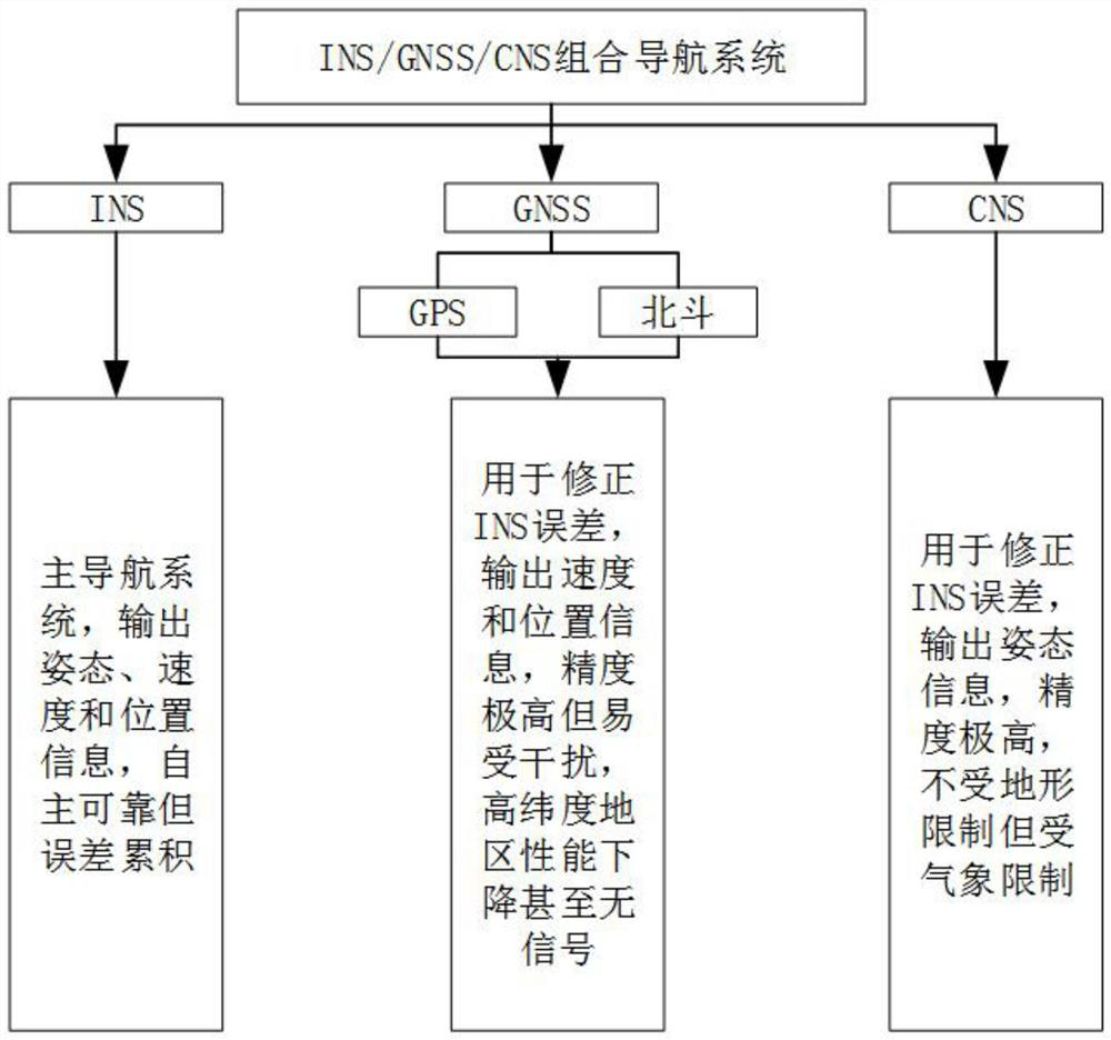
[0075] Aiming at the rapid development of civil aviation polar flight, and the ability of civil aviation navigation to independently and reliably guarantee full time and space in the future, the present invention consists of INS navigation system, GNSS navigation system composed of GPS and Beidou satellites, and INS / GNSS / CNS integrated navigation system composed of CNS navigation system system, the integrated navigation system is not limited by time and space, realizes real global flight reporting precision navigation, and can also diagnose each navigation system in real time (the navigation system referred to in this embodiment refers to the INS navigation system, GNSS navigation system or CNS navigation system) Navigation system) working status (working status includes normal and fault), isolate the faulty navigation system, and realize autonomous navigation in complex environments.

[0076] See figure 1 , the system of this scheme is an INS / GNSS / CNS integrated navigation sy...


PUM


Abstract

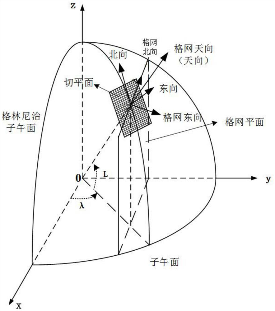
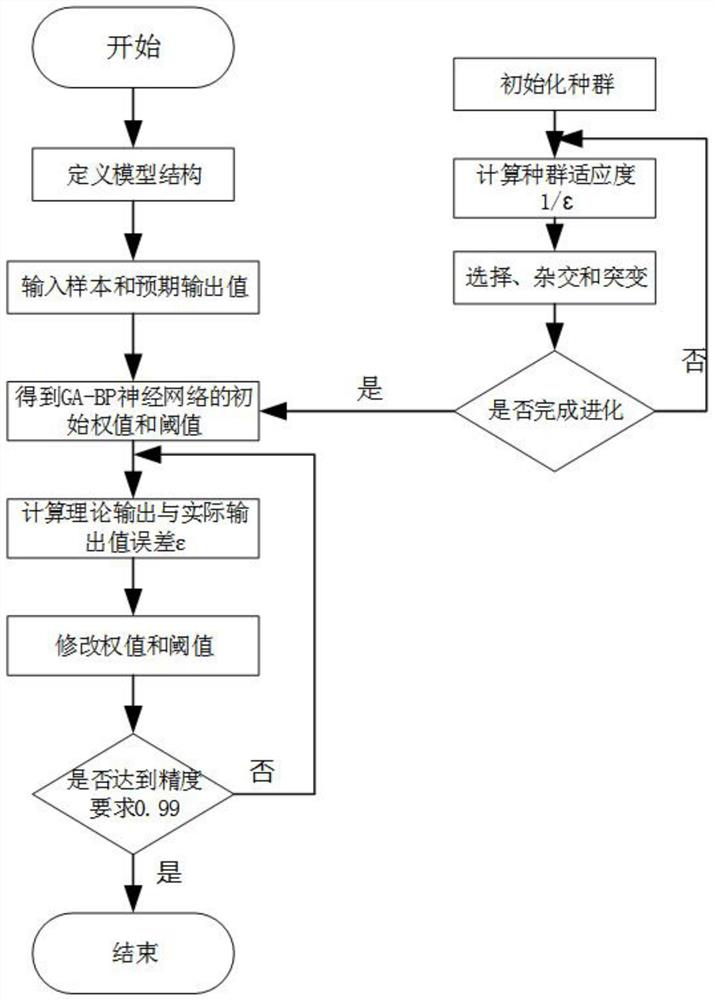
The invention relates to a full-space-time integrated navigation system and navigation method for a civil aircraft, and the method comprises the steps: converting the speed and attitude information outputted by an INS, a GNSS, and a CNS to a grid coordinate system, and converting the position information to an earth-centered earth-fixed coordinate system; transmitting the converted data to a GA-BP neural network for fault detection; diagnosing whether the INS, the GNSS and the CNS have faults or not; if the data of a certain navigation system is abnormal, isolating the data of the navigation system, transmitting the data of other normal navigation systems to a Kalman filter for fusion filtering, and outputting navigation information; and performing feedback correction on the INS by using the navigation information. The INS / GNSS / CNS integrated navigation system is composed of the INS navigation system, the GNSS navigation system and the CNS navigation system, the integrated navigation system is not limited by time and space, real global flight high-precision navigation is achieved, meanwhile, the working state of each navigation system can be diagnosed in real time, the fault of the navigation system can be isolated, and autonomous navigation in a complex environment is achieved.

Description

technical field [0001] The invention relates to the technical field of civil aviation aircraft navigation, and is particularly suitable for a full-time and full-space combined navigation system and navigation method for civil aviation flights. Background technique [0002] At this stage, although the integrated navigation system INS navigation system / GPS of civil aviation aircraft can meet the aircraft navigation needs most of the time, it still has deficiencies under certain conditions such as flying in polar regions. [0003] The magnetic longitude difference in the polar region is too large and the magnetic field is abnormal, so the traditional magnetic compass orientation method is no longer applicable. The polar area navigation meridians converge rapidly. Under the current Northeast Celestial Navigation Coordinate System, there are problems in the calculation of inertial navigation mechanics and the difficulty of azimuth gyro torque application. The electromagnetic env...

Claims


Application Information

Patent Timeline
Patent Type & Authority Applications(China)
IPC IPC(8): G01C21/16G01C21/20G01S19/49
CPCG01C21/165G01C21/20G01S19/49
Inventor 张强吉鹏伍瀚宇焦浩博
Owner CIVIL AVIATION FLIGHT UNIV OF CHINA
Learn More