Method for calculating gravitational potential difference between sea-crossing elevation points

A calculation method and elevation point technology, which is applied in complex mathematical operations, height/horizontal measurement, satellite radio beacon positioning system, etc., can solve the problem of reducing the accuracy of the calculation results of gravity headroom, and achieve high-precision cross-sea elevation points Gravity potential difference calculation, effect of improving calculation accuracy

Active Publication Date: 2021-12-21
JIANGSU OCEAN UNIV
View PDF18 Cites 1 Cited by
  • Summary
  • Abstract
  • Description
  • Claims
  • Application Information

AI Technical Summary

Problems solved by technology

This method applies the theory of gravity potential difference to the cross-sea elevation transfer. In this method, the sea surface dynamic topography difference is one of the main factors affecting the calculation of the potential difference. Since the sea surface dynamic topography cannot be measured on site, only The difference between the average sea surface obtained by satellite altimetry and the geoid obtained by the earth's gravity field model is obtained to obtain the dynamic sea surface topography. Due to the resolution problem of the altimetry sea surface height model and the earth's gravity field model, there are many gaps between the measured results and the reduced The accuracy of the calculation results of gravity displacement is improved

Method used


Image

  • Method for calculating gravitational potential difference between sea-crossing elevation points
  • Method for calculating gravitational potential difference between sea-crossing elevation points
  • Method for calculating gravitational potential difference between sea-crossing elevation points

Examples


Embodiment 1

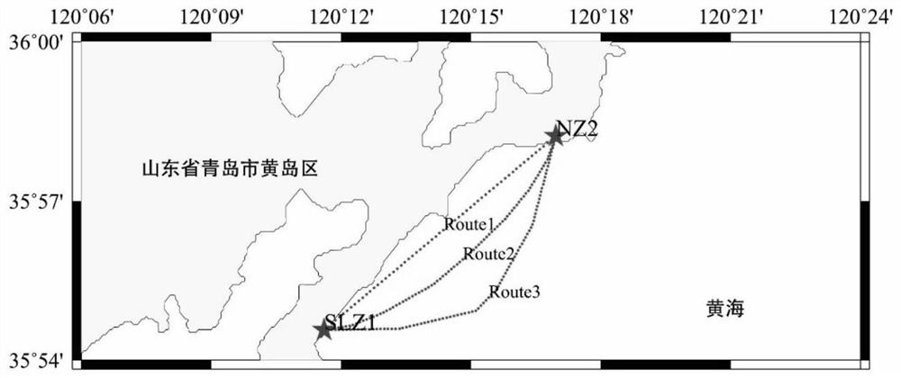
[0087] As shown in the figure, there are two known points SLZ1 and NZ2 along the seaside, about 10.5km from the two points, known the two points of CGCS2000 coordinates and normal high (Table 1), and in these two points Astronomical Ground Vertical Deviation Measurement. One point (SLZ1) is selected as the land known, and the other (NZ2) is analog test in the island to be measured. The experiment was carried out by analog route, and three routes were selected, and the ship measurement gravity data G of I I was measured. i , Use DTU 10 to calculate the gravity abnormal ΔG i Plus normal gravity γ i Simulation get, g i = Γ i + ΔG i

[0088]The average sea surface high by the ship-in-load GNSS line detection point I is obtained by the DTU 10 simulation, and the remaining method is calculated. The number of route measuring points is related to the distance of the measurement section on the route. Three routes are simulated in the test, and the measurement of each route is 0.2km, 0.5km...


PUM


Abstract

The invention discloses a method for calculating gravitational potential difference between sea-crossing elevation points, which is used for determining the elevation of islands (reefs) around the land in coastal countries. The method comprises the steps of carrying out astronomical geodetic plumb deviation, gravity and GNSS geodetic height measurement on elevation points on two sides of land and an island; measuring measuring point gravity data and GNSS sea surface height between land and sea in a shipborne gravity / GNSS measuring line mode, and reducing corrected gravity / geodetic height data to an average sea surface; deducing a calculation formula of a gravity potential difference between sea-crossing elevation points according to a gravity potential theory and an astronomical level principle; in combination with astronomical earth vertical line deviations on elevation points on the two sides of land and sea, improving the vertical line deviation precision of measuring lines and measuring points according to a removal-recovery technology; and substituting the result into a deduced gravitational potential difference calculation formula to realize sea-crossing gravitational potential difference calculation. The gravitational potential difference between sea-crossing elevation points is calculated by utilizing actually measured elevation point data of a certain place in Shandong Province, the distance of the elevation points is about 10.5 km, and an elevation value calculated according to the gravitational potential difference meets the level measurement accuracy requirement of the national level measurement specification III.

Description

Technical field [0001] The present invention relates to a method of calculating a gravity zone difference between a long-distance cross-sea elevated point, in particular, a linear cross-sea elevation of astronomical landlines, GNSS measurement, and carrier gravity / GNSS. Calculation method of gravity selections between disc. Background technique [0002] The gravity fraction calculation of the cross-sea elevated point can be used to complete the land, the island elevation benchmark. my country is a marine big country, with many islands (reefs) in coastal areas. Establishing a unified island (reef) elevation system, which can serve the development and protection of islands (reefs), marine environmental protection, marine disaster monitoring and marine resource exploration and development. Therefore, the unified land sea elevation system is of great significance in scientific research, national economic construction and national defense construction. Traditional gravity zerogenic ...

Claims


Application Information

Patent Timeline
Patent Type & Authority Applications(China)
IPC IPC(8): G01C5/00G01D21/02G01S19/14G06F17/15
CPCG01C5/00G01D21/02G01S19/14G06F17/15Y02A90/10
Inventor 王建波陈顺德齐鑫敏周睿康肖开林韩友美
Owner JIANGSU OCEAN UNIV
Why Eureka
Try Eureka