Method for calculating coordinates at any stake mark on route

A calculation method and coordinate calculation technology, applied in the field of coordinate calculation, can solve problems such as error-prone, complex calculation, and large amount of calculation.

Pending Publication Date: 2022-01-14
广东云茂高速公路有限公司 +1
View PDF0 Cites 1 Cited by
  • Summary
  • Abstract
  • Description
  • Claims
  • Application Information

AI Technical Summary

Problems solved by technology

[0004] The traditional route coordinate calculation method will choose different methods according to the different route line elements (mainly straight lines, circular curves and transitional curves), and the calculation amount is large, the calculation is complex, and error-prone

Method used


Image

  • Method for calculating coordinates at any stake mark on route
  • Method for calculating coordinates at any stake mark on route
  • Method for calculating coordinates at any stake mark on route

Examples


Embodiment

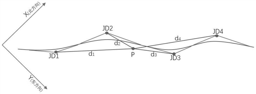
[0029] A calculation method for the coordinates of any stake number on the route, see Figure 1-Figure 2 , including the following steps:

[0030] Step 1: According to the design route information and the stake number sn at point P, determine the intersection interval and alignment of point P;

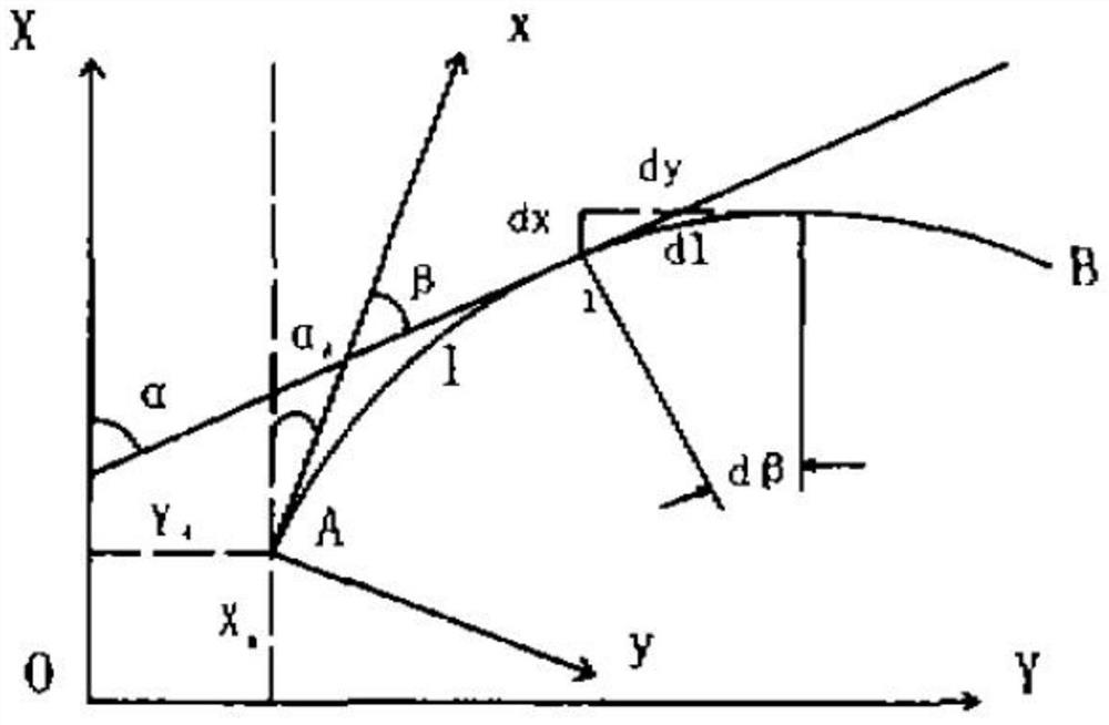
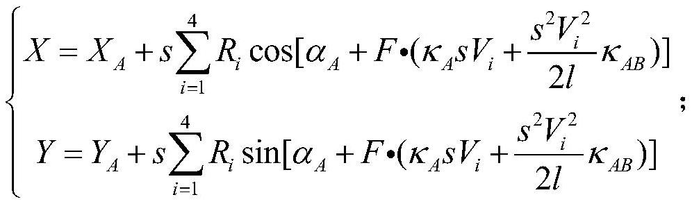
[0031] Step 2: Calculate the line coordinates of point P by using the numerical integration method according to the line shape information of point P;

[0032] Step 3: Calculate the control coordinates of the side piles according to the coordinates of point P.

[0033] Optionally in the present invention, the method for judging the intersection point S of the intersection point interval to which it belongs by the mileage sn of point P is specifically:

[0034] Find the intersection point JD closest to sn m , JD m =min(|JD i _sn-sn|), i=1, 2, 3,..., k, where k is the number of intersections in the design line, JD i _sn for JD i mileage, min is the minimum value function;

[0035...


PUM


Abstract

The invention discloses a method for calculating coordinates at any stake mark on a route. The method comprises the following steps of: judging an intersection interval and a line shape of a point P according to design route information and a stake mark sn at the point P; calculating the line coordinate of the P point by using a numerical integration method according to the linear information of the P point; and calculating the control coordinate of the side pile according to the coordinate of the P point. According to the integral relation between the curvature and the mileage, the calculation general formula of the edge pile in the line is deduced, then the calculation models of all the line elements are the same by utilizing the numerical calculation method of the integral, and different calculation methods do not need to be selected according to the difference of the line elements; according to the calculation method provided by the invention, the calculation result is the same coordinate in the line control coordinate system, and secondary coordinate conversion is not needed; the calculation method provided by the invention is rigorous in theory, simple in formula and convenient for programming implementation.

Description

technical field [0001] The invention relates to the technical field of road surveying and construction stakeout, in particular to a method for calculating coordinates at any stake number on a route. Background technique [0002] According to the "Statistical Bulletin on the Development of the Transportation Industry in 2016" issued by the Ministry of Transport, by the end of 2016, the total mileage of my country's highways reached 4.6963 million km, and the road density was 48.92km / km 2 , 4.2265 million kilometers of roads above grade, and 131,000 kilometers of expressways. In the measurement process of highways, railways and other roads, it is necessary to stake out according to the design line to determine the vertical and horizontal sections and design the construction drawings; [0003] The stakeout method has changed from the traditional deflection method and branch distance method to the more flexible and convenient polar coordinate method and GPSRTK stakeout method. ...

Claims


Application Information

Patent Timeline
Patent Type & Authority Applications(China)
IPC IPC(8): G06F17/15G06F17/11
CPCG06F17/15G06F17/11
Inventor 韩富庆娄健马增琦郭国和曾雄鹰吴勇生孙文晋蔡敏万永涛姬亚磊文言杨承昆
Owner 广东云茂高速公路有限公司
Why Eureka
Try Eureka