
Agile remote sensing satellite on-orbit autonomous focusing method based on lunar imaging

A remote sensing satellite and imaging technology, applied in the field of optical remote sensing satellite on-orbit focusing, can solve problems such as the influence of evaluation results, difficulty in obtaining images, and difficulty in regular monitoring methods, and achieve the effect of improving evaluation consistency and stable target characteristics.

Pending Publication Date: 2022-01-18
CHINA ACADEMY OF SPACE TECHNOLOGY
View PDF0 Cites 0 Cited by
  • Summary
  • Abstract
  • Description
  • Claims
  • Application Information

AI Technical Summary

Problems solved by technology

[0004] This type of focusing method for ground imaging has the following deficiencies: 1) Most remote sensing satellites are low-orbit satellites, which need to image the ground by push-broom, and it is difficult to obtain images of the same target area before and after focusing in a short period of time. The calculation of sharpness is directly related to the observed ground objects, and the evaluation results will be affected; 2) For agile remote sensing satellites, continuous multiple imaging of the same target area can be achieved through attitude maneuvering, but the different observation geometries during the imaging period lead to imaging Atmospheric conditions such as aerosol thickness in the path are different, which will also affect the definition calculation results; 3) Statistics show that due to cloud cover and light conditions, the actual available images only account for a small part of the satellite's total imaging data, while Among them, the images of ground object types suitable for focusing definition evaluation only account for a very small part; 4) Due to the first three reasons, it is necessary to download a large amount of image data when implementing focusing, and manually screen to obtain similar images under similar imaging conditions. The evaluation results of ground object images can only be obtained after multiple trial calculations, and rapid on-orbit autonomous focusing cannot be achieved; 5) Due to the many requirements of the existing methods, the long implementation period, and the need for manual intervention, it is difficult to use them as a regular monitoring method. Focusing is performed only when the quality has degraded to a certain extent

Method used


Image

  • Agile remote sensing satellite on-orbit autonomous focusing method based on lunar imaging
  • Agile remote sensing satellite on-orbit autonomous focusing method based on lunar imaging
  • Agile remote sensing satellite on-orbit autonomous focusing method based on lunar imaging

Examples


Embodiment

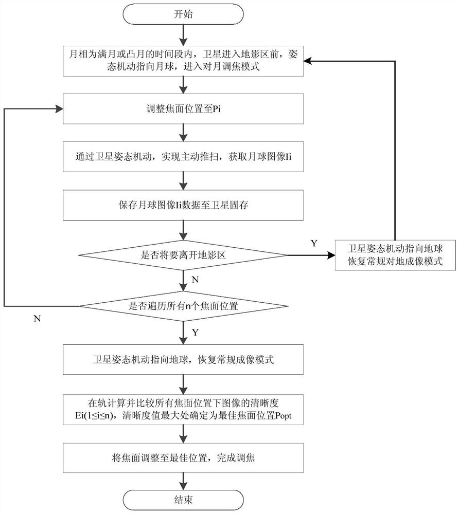
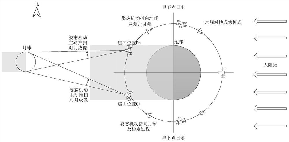
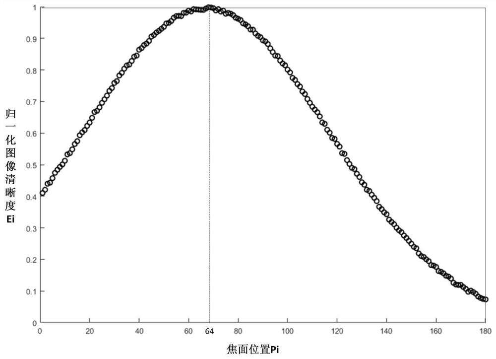
[0072] In this example, given that an agile remote sensing satellite is in a sun-synchronous orbit with an altitude of 640km, its orbital inclination is 98°, its flight speed is about 7.5km / s, and each orbit is in the shadow area for 35 minutes; the maximum attitude maneuvering speed of the satellite is 4.5° / s, the pointing stabilization time is less than 8 seconds; the pixel size of the satellite imaging payload is 7um, the focal length is 11000mm, the field of view is 1.34°, the default integration time is 60us, the focusing range is ±2mm, and the focusing step is 25um; During the focusing mission, the moon phase is full moon, the angle of the moon to the satellite is about 0.5°, and the distance between the stars and the moon is about 384,000km.

[0073] According to the formula, it can be calculated that the active push-broom speed is about 0.61° / s when imaging the moon, and the time required to complete a cycle of imaging the moon is about 9s; the total number of focal pl...


PUM


Abstract

The invention discloses an agile remote sensing satellite on-orbit autonomous focusing method based on lunar imaging, and the method comprises the following steps: enabling the satellite to carry out attitude maneuver when the lunar phase is a full moon or a convex moon, enabling the satellite to be converted from earth pointing to lunar pointing, enabling the satellite to reach a stable state, and entering a lunar focusing mode; when the agile remote sensing satellite is in the earth shadow area, controlling the load focusing mechanism to adjust the focal plane position, and obtaining lunar images corresponding to the n focal plane positions; the satellite carries out attitude maneuver, and lunar pointing is converted into earth pointing; and the on-satellite data processing subsystem performs on-orbit calculation on the definition of all moon images, and determines the position with the maximum definition value as the optimal focal plane position. The moon images at different focal plane positions are obtained through attitude maneuver, the definition is calculated, the optimal focal plane position is judged, and the problem that an existing on-orbit focusing method depends on human intervention is solved.

Description

technical field [0001] The invention belongs to the technical field of on-orbit focusing of optical remote sensing satellites, and in particular relates to an on-orbit autonomous focusing method of agile remote sensing satellites based on lunar imaging. Background technique [0002] Due to the influence of factors such as air pressure changes, thermal environment changes, launch section vibration, and stress release under zero-gravity conditions, the focal plane position of the imaging payload will change after the remote sensing satellite enters orbit, resulting in out-of-focus images. In order to ensure the quality of satellite imaging, it is necessary to adjust the focus of the imaging payload on-orbit and monitor the defocusing situation regularly. [0003] At present, optical remote sensing satellites mostly adopt a focusing method based on ground imaging, that is, using satellite remote sensing images of typical ground objects such as cities to calculate the definition...

Claims


Application Information

Patent Timeline
Patent Type & Authority Applications(China)
IPC IPC(8): G01C21/24
CPCG01C21/24
Inventor 殷延鹤莫凡赵晨光徐驰张新伟
Owner CHINA ACADEMY OF SPACE TECHNOLOGY
Learn More