Check patentability & draft patents in minutes with Patsnap Eureka AI!

High-precision map precision detection method based on projection transformation

A technology of projection transformation and accuracy detection, applied in image analysis, image data processing, graphics and image conversion, etc., can solve the problems of infeasibility, single high-precision map detection method, and inability to high-precision map detection, etc., to improve the accuracy Effect

Pending Publication Date: 2022-01-21
上海智能网联汽车技术中心有限公司
View PDF0 Cites 2 Cited by
  • Summary
  • Abstract
  • Description
  • Claims
  • Application Information

AI Technical Summary

Problems solved by technology

[0002] Collecting point cloud and image data by building a data standard car, and then reconstructing the road environment through data processing is a common high-precision map drawing method at present. Due to factors such as obstructions and road surface wear, certain problems will occur in the process of drawing high-precision maps. Therefore, it is necessary to further verify the accuracy of the high-precision map. At present, there are few existing high-precision map detection methods. Usually, the high-precision map drawn by collecting data and reconstructing the road environment is compared with the CAD construction map or compared with the total station Compare the coordinates of the joint surveying and mapping calibration of the instrument and RTK to check whether the high-precision map can achieve lane-level accuracy
[0003] At present, the detection method of high-precision map is relatively simple. The method of comparison with CAD drawing mainly compares the contours of the two maps, and because CAD drawing does not contain coordinate information, it can only detect whether the rough contour or local size of the high-precision map is consistent with the The CAD drawings of the area are matched, but the CAD drawings only contain the size information of each part of the area, and

Method used


Image

  • High-precision map precision detection method based on projection transformation
  • High-precision map precision detection method based on projection transformation
  • High-precision map precision detection method based on projection transformation

Examples


Embodiment

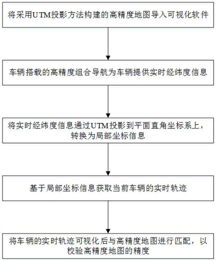
[0035] The present invention provides a high-precision map accuracy detecting method based on projected transformation, which is passed through a vehicle mount combined inertial guide device, which is built in a high-precision map area, collects real-time latitude and latitude information of current vehicles, due to latitude and longitude Intuitive reflecting the distance information under the right angle coordinate system, the same projection transformation method using high precision maps is required to control variables, the projection transform method includes UTM projection (General Horizontal Mo Jumo projection method), TM projection (Horizontal Metal Tour) and Gaussian Projection, the high-precision map accuracy detection method proposed by this method uses a UTM projection method to construct high precision maps, and detect high precision map accuracy based on the UTM projection method.

[0036] The UTM coordinate projected as an ellipsoid, the centerline of the elliptical...


PUM


Abstract

The invention relates to a high-precision map precision detection method based on projection transformation. The method comprises the following steps: step 1, performing visualization processing on a high-precision map constructed based on a UTM projection method after format conversion; 2, collecting centimeter-level vehicle high-precision positioning information, namely real-time longitude and latitude information of the vehicle, through detection equipment carried by the vehicle; 3, projecting real-time longitude and latitude information of the vehicle to a rectangular plane coordinate system through UTM, and converting the real-time longitude and latitude information into local coordinate information; 4, acquiring a real-time track of the current vehicle running on the rectangular plane coordinate system based on the local coordinate information; 5, visualizing the real-time track of the vehicle and then matching with the high-precision map to detect the precision of the high-precision map. Compared with the prior art, the invention has the advantages that the precision of the high-precision map can be detected more clearly and visually, and the vehicle positioning precision is improved.

Description

Technical field [0001] The present invention relates to the field of high-precision map precision detection, and more particularly to a high-precision map accuracy detection method based on projected transformation. Background technique [0002] By building data standard car acquisition point clouds, image data, and then constructs a common high-precision map drawing method via data processing, due to factors such as shield, road surface wear, can result in a high precision map process. Error, thus need to further verify the accuracy of the high-precision map, currently existing high-precision map detection methods, usually used by collecting data, refactoring road environment, compared with CAD construction drawings, or to The instrument and RTK combine the coordinate comparison of the calibration, detecting the high-precision map accuracy of the lane level. [0003] At present, the high-precision map detection method is more single, and the method compared to the CAD drawing is...

Claims


Application Information

Patent Timeline
IPC IPC(8): G06T3/00G06T7/73G06T17/05
CPCG06T3/0031G06T7/73G06T17/05
Inventor 姜乐殷承良吴璇琪李波刘续博
Owner 上海智能网联汽车技术中心有限公司
Features
  • R&D
  • Intellectual Property
  • Life Sciences
  • Materials
  • Tech Scout
  • Unparalleled Data Quality
  • Higher Quality Content
  • 60% Fewer Hallucinations
Learn More