Method for acquiring elevation of certain point of remote sensing image based on laser range finder and holder

A laser rangefinder and remote sensing image technology, which is applied in image data processing, instruments, measuring devices, etc., can solve the problem of lack of elevation information in remote sensing maps

Pending Publication Date: 2022-02-01
NO 54 INST OF CHINA ELECTRONICS SCI & TECH GRP
View PDF0 Cites 0 Cited by
  • Summary
  • Abstract
  • Description
  • Claims
  • Application Information

AI Technical Summary

Problems solved by technology

[0004] In view of this, the present invention provides a method for obtaining the elevation of a point in a remote sensing image based on a laser range finder and a cloud platform, which can solve the problem of missing elevation information in existing remote sensing maps

Method used


Image

  • Method for acquiring elevation of certain point of remote sensing image based on laser range finder and holder
  • Method for acquiring elevation of certain point of remote sensing image based on laser range finder and holder
  • Method for acquiring elevation of certain point of remote sensing image based on laser range finder and holder

Examples


Embodiment Construction

[0027] The following will clearly and completely describe the technical solutions in the embodiments of the present invention with reference to the accompanying drawings in the embodiments of the present invention. Obviously, the described embodiments are only some, not all, embodiments of the present invention. Based on the embodiments of the present invention, all other embodiments obtained by persons of ordinary skill in the art without making creative efforts belong to the protection scope of the present invention.

[0028] In addition, the technical solutions of the various embodiments of the present invention can be combined with each other, but it must be based on the realization of those skilled in the art. When the combination of technical solutions is contradictory or cannot be realized, it should be considered as a combination of technical solutions. Does not exist, nor is it within the scope of protection required by the present invention.

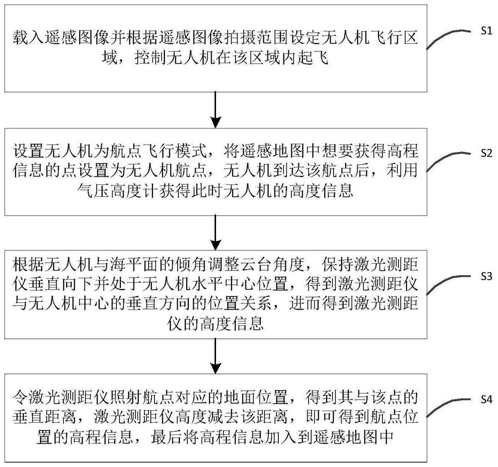
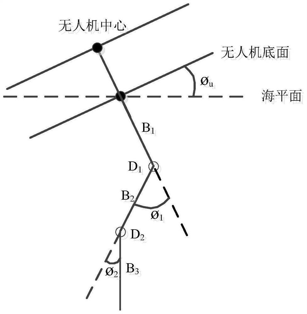
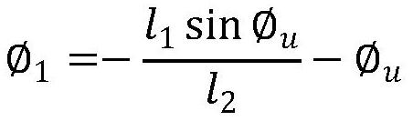
[0029] A method for obt...


PUM


Abstract

The invention discloses a method for acquiring elevation of a certain point of a remote sensing image based on a laser range finder and a holder, and belongs to the field of autonomous navigation and remote sensing images. According to the method, an unmanned aerial vehicle is controlled to take off in a remote sensing image area, a waypoint flight mode is set, a point which wants to obtain elevation information is set as a waypoint, height information of the unmanned aerial vehicle is obtained through a barometric altimeter after the unmanned aerial vehicle reaches the waypoint, and a pan-tilt angle is adjusted according to an inclination angle between the unmanned aerial vehicle and the sea level, the position relation between the unmanned aerial vehicle and the laser range finder is obtained, then height information of the laser range finder is obtained, the laser range finder irradiates vertically downwards, the vertical distance between the laser range finder and the waypoint position is obtained, then elevation information of the waypoint position in a remote sensing map is obtained, and finally the elevation information is added to a remote sensing image. Compared with an existing remote sensing map, the elevation information of a certain point in the remote sensing image can be obtained, and more references can be provided for users of the remote sensing map.

Description

technical field [0001] The invention relates to the fields of autonomous navigation and remote sensing images, in particular to a method for obtaining the elevation of a certain point in a remote sensing image based on a laser range finder and a cloud platform. Background technique [0002] Remote sensing map is a kind of visual map, which contains the latitude and longitude information of each pixel point, but the current remote sensing map lacks the elevation information of each point, and cannot provide height reference for users. If you can add elevation information to a point where you want to obtain elevation information, the information in the remote sensing map will be more abundant, which can provide users with more references. [0003] At present, most drones are equipped with laser range finders. However, although the laser rangefinder can measure the distance between two points, it cannot always be kept parallel to the sea level during the flight of the drone, a...

Claims


Application Information

Patent Timeline
Patent Type & Authority Applications(China)
IPC IPC(8): G06T17/05G06F16/29G01S17/08
CPCG06T17/05G06F16/29G01S17/08
Inventor 耿虎军高峰李晨阳关俊志张泽勇柴兴华陈彦桥王雅涵蔡迎哲牛韶源
Owner NO 54 INST OF CHINA ELECTRONICS SCI & TECH GRP
Why Eureka
Try Eureka