Method and system for inverting submarine topography based on satellite altimeter

A technology of altimeter and satellite altimetry, applied in the field of seabed terrain inversion, can solve the problems of difficulty in determining the optimal density difference constant and low spatial resolution of seabed terrain inversion

Pending Publication Date: 2022-03-04
OCEAN UNIV OF CHINA
View PDF13 Cites 3 Cited by
  • Summary
  • Abstract
  • Description
  • Claims
  • Application Information

AI Technical Summary

Problems solved by technology

[0005] In view of the above defects and improvement needs of the prior art, the purpose of this application is to provide a method and system for inverting seabed topography based on satellite altimeter to solve the problem of low spatial resolution of seabed topography inversion and determination of optimal density difference constant Difficult problems, and then solve the technical limitations of high-precision, high-resolution seabed terrain inversion

Method used


Image

  • Method and system for inverting submarine topography based on satellite altimeter
  • Method and system for inverting submarine topography based on satellite altimeter
  • Method and system for inverting submarine topography based on satellite altimeter

Examples


Embodiment Construction

[0044] In the following description, numerous specific details are set forth in order to provide a thorough understanding of the application. However, the present application can be implemented in many other ways different from those described here, and those skilled in the art can make similar promotions without violating the connotation of the present application. Therefore, the present application is not limited by the specific implementation disclosed below.

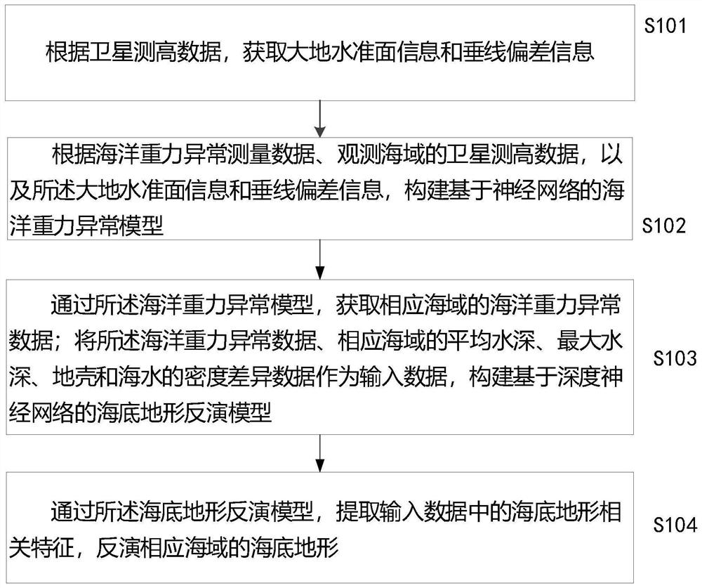
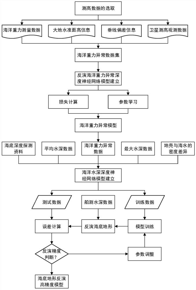
[0045]Through the analysis of a large amount of ocean gravity data information and seabed topography data, the application can know that the change of seabed topography and topography will cause the change of sea surface gravity to a certain extent, and there is a certain corresponding relationship between them. Therefore, through this relationship, we can use Ocean gravity information is used to invert seabed topography, especially in deep sea areas that have not been fully explored by humans so far. This method can ...


PUM


Abstract

The invention discloses a method for inverting submarine topography based on a satellite altimeter, and the method comprises the steps: obtaining geoid information and vertical line deviation information according to satellite height measurement data; constructing an ocean gravity anomaly model based on a neural network according to ocean gravity anomaly measurement data, satellite height measurement data of an observation sea area, the geoid information and the plumb line deviation information; acquiring ocean gravity anomaly data of the corresponding sea area through the ocean gravity anomaly model; taking the ocean gravity abnormal data, the average water depth and the maximum water depth of the corresponding sea area, and the density difference data of the crustal and the seawater as input data, and constructing a submarine topography inversion model based on a deep neural network; and through the submarine topography inversion model, extracting submarine topography related features in the input data, and inverting the submarine topography of the corresponding sea area. The problems that the spatial resolution of submarine topography inversion is low and the optimal density difference constant is difficult to determine are solved.

Description

technical field [0001] The present application relates to the technical field of seabed terrain inversion, in particular to a method and system for inverting seabed topography based on satellite altimeter. Background technique [0002] The detailed description of the shape of the seabed is of great significance to human beings. The seabed topography or bathymetry provides basic data for many applications such as navigation safety, marine engineering construction, and marine scientific research. Traditionally, the surveying and mapping of seabed topography is carried out by ship-borne echo sounding measurement. Due to the limitations of technical conditions such as high project cost, long measurement cycle, and sparse measurement data, there is currently a problem of data gaps in large areas of the sea. The emergence of satellite radar altimeters With its advantages of large coverage area, strong detection ability, large amount of information, and rapid observation of ocean c...

Claims


Application Information

Patent Timeline
Patent Type & Authority Applications(China)
IPC IPC(8): G01V7/00G01V7/06G06F30/15G06F30/27G06N3/08
CPCG01V7/00G01V7/06G06F30/15G06F30/27G06N3/084
Inventor 魏志强杨巧巧黄磊
Owner OCEAN UNIV OF CHINA
Why Eureka
Try Eureka