Supercharge Your Innovation With Domain-Expert AI Agents!

CORS normal high positioning method and system

A positioning method and positioning system technology, applied in the field of data surveying and mapping, can solve problems such as user terminal compatibility and data leakage, and achieve the effect of improving service capabilities and ensuring data security

Pending Publication Date: 2022-04-12
湖南省测绘科技研究所
View PDF0 Cites 0 Cited by
  • Summary
  • Abstract
  • Description
  • Claims
  • Application Information

AI Technical Summary

Problems solved by technology

This method requires the user terminal to be able to receive and analyze the quasi-geoid model data, and there is a compatibility problem with the user terminal. At the same time, this method directly broadcasts the quasi-geoid model data to the outside world, and there is a risk of data leakage

Method used


Image

  • CORS normal high positioning method and system

Examples


Embodiment Construction

[0029] The present invention will be described in detail below in conjunction with the accompanying drawings. The description in this part is only exemplary and explanatory, and should not have any limiting effect on the protection scope of the present invention. In addition, those skilled in the art can make corresponding combinations of features in the embodiments in this document and in different embodiments according to the descriptions in this document.

[0030] The technical terms that may be involved in this patented technology are explained as follows:

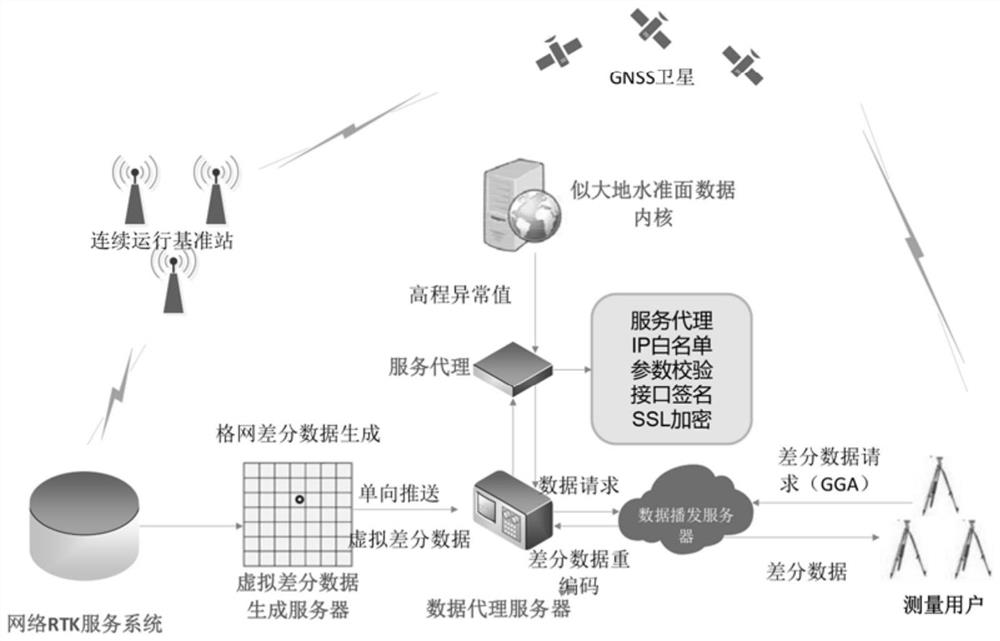
[0031] Global Navigation Satellite System (GNSS): GNSS positioning is based on observations such as pseudorange, ephemeris, and satellite launch time of a group of satellites, and the user's clock error must also be known. GNSS is a space-based radio navigation and positioning system that can provide users with all-weather 3-dimensional coordinates, speed and time information at any point on the earth's surface or near...


PUM


Abstract

The invention discloses a CORS normal high positioning method. The method comprises the following steps: receiving a differential data request and position data sent by the differential data request; dividing the service range of the network RTK into a plurality of grids, and calculating a grid where a differential data request sending position is located; receiving position data sent by the differential data request, and acquiring an elevation abnormal value of the position data from the geoid-like data kernel; adding the obtained elevation abnormal value into a virtual reference station coordinate of a grid where a differential data request sending position is located, and generating virtual differential data; and the differential data requester carries out differential positioning on the received virtual differential data and satellite observation data of the differential data requester to obtain a positioning result. Because the reference station coordinates in the virtual differential data are subjected to elevation anomaly correction, the positioning result is also subjected to elevation anomaly correction, and a normal high result is obtained through direct measurement. The invention also discloses a CORS normal high positioning system.

Description

technical field [0001] The invention belongs to the field of data surveying and mapping, and in particular relates to a CORS normal height positioning method and system. Background technique [0002] The Continuously Operating Reference Station System (CORS) can improve the accuracy of satellite navigation and positioning from 5-10 meters to the centimeter level, and has become an important part of the new infrastructure. The elevation of the positioning result of the network RTK service provided by the CORS system is the geodetic height, that is, the distance from the measurement point to the reference ellipsoid. The network RTK service architecture of the existing CORS system is that users directly request differential correction information from the data center, and send user location data to the data center. The data center calculates differential reconstruction information based on the user's location, and returns differential correction information to the user after th...

Claims


Application Information

Patent Timeline
IPC IPC(8): G01C5/00G01S19/14G01S19/41
Inventor 敖敏思曾翔强陈春花黎晨曦楚彬张玉冰
Owner 湖南省测绘科技研究所
Features
  • R&D
  • Intellectual Property
  • Life Sciences
  • Materials
  • Tech Scout
  • Unparalleled Data Quality
  • Higher Quality Content
  • 60% Fewer Hallucinations
Learn More