Monitoring, evaluation and early warning method of street space quality
What is AI technical title?
AI technical title is built by Patsnap AI team. It summarizes the technical point description of the patent document.
A street and space technology, applied in the field of space quality monitoring, evaluation and early warning, can solve problems such as neglect of accessibility, comfort and practicability, ineffective utilization of urban comprehensive functions, and easy neglect of details, so as to improve quality and efficiency. The effect of efficiency
Active Publication Date: 2022-05-27
河北省地理信息集团有限公司 +1
View PDF0 Cites 0 Cited by
Summary
Abstract
Description
Claims
Application Information
AI Technical Summary
This helps you quickly interpret patents by identifying the three key elements:
Problems solved by technology
Method used
Benefits of technology
Problems solved by technology
[0003] At present, the basic indicators for the evaluation of the status quo of land space development and protection in cities and counties include the coverage rate of 15-minute walks in forests, the 5-minutes walk coverage rate of park green spaces and squares, the 15-minutes walk coverage rate of community health and medical facilities, the 15-minutes walk coverage rate of community sports facilities, the coverage rate of fire protection Rescue 5-minute reachable coverage and other indicators related to coverage analysis are calculated only from the perspective of buffer zone analysis. There are many problems in this method, such as ignoring accessibility, comfort and practicality
Moreover, with the development and application of modern technology, most of the current urban planning actively advocates centralized and large-scale public space, and divides the city into several major sections such as residence, work, entertainment, and transportation. Planning evaluation based on human feelings
These methods lead to the fragmentation of the city as a whole, the comprehensive functions of the city cannot be effectively utilized, and the details are easily overlooked
Method used
Image
Click on the blue label to locate the original text in one second.
Reading with bidirectional positioning of images and text.
Examples
Embodiment Construction
[0061] Below in conjunction with embodiment, the present invention is described in further detail:
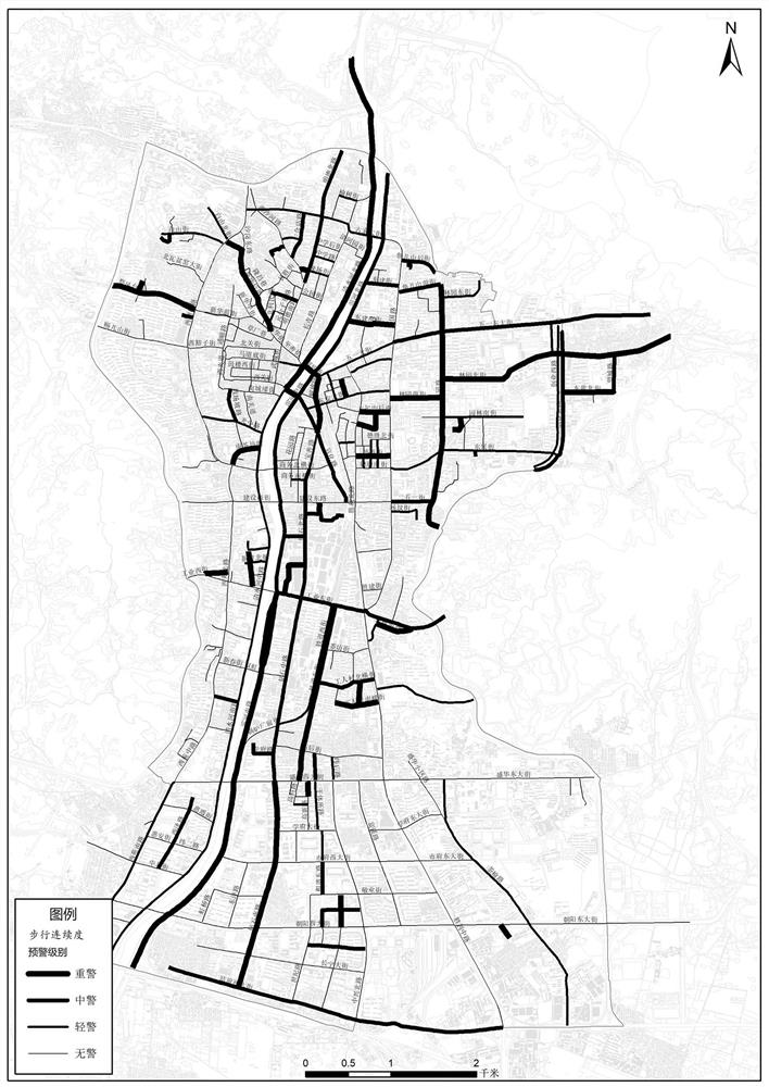
[0062] A method for monitoring and evaluating early warning of street space quality, comprising the following steps:
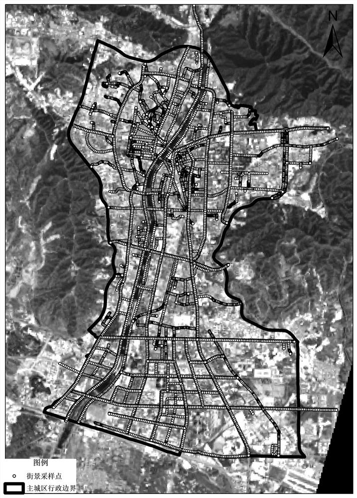
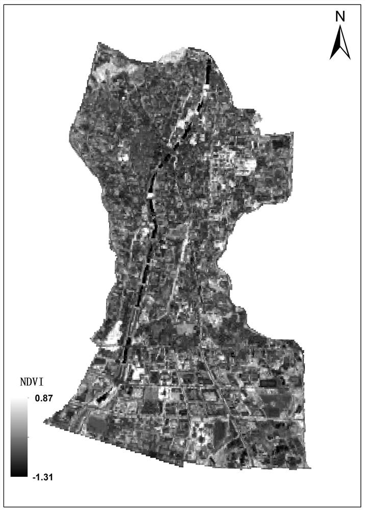
[0063] S1, data collection, collect all kinds of planning data, street view data, digital city geospatial frame data, Internet street view map data; the specific methods are:
[0064] Based on the urban road vector data, the road is equidistantly 50m apart and interrupted by nodes. According to the starting and ending points of each road section after the interruption, the actual direction of the road and the forward angle of view are calculated. The other three perspectives, according to the node coordinates and the direction perspective, can download the street view pictures in the four perspective directions of the sampling point through the Baidu map API.
[0065] S2, data collection, using high-precision mobile measurement vehicles to supplement the colle...
PUM
Abstract
The invention discloses a street space quality monitoring, evaluation and early warning method, belonging to the technical field of street space quality evaluation, including: S1, data collection, collecting various planning data, street view data, digital city geographic space frame data, Internet street view map data; S2, data collection, supplementary collection of part of street view data and 3D laser point cloud data; S3, data processing: use machine learning to extract and establish the pixel ratio, element boundary, and quantity information of each element; S4, establish street space quality Database: store the collected, collected and processed information in the database, and associate the street view image data with the basic space; S5, establish an index system, and determine the target-oriented value of the measurement and evaluation index of street space quality; S6, establish an early warning system , determine the early warning threshold, and divide the status of light alarm, medium alarm, and heavy alarm, making the evaluation more efficient and faster.
Description
technical field [0001] The invention relates to the technical field of street space quality evaluation, in particular to a space quality monitoring and evaluation early warning method. Background technique [0002] Land and spatial planning and construction and status assessment work require that efforts should be made to find out the prominent contradictions in the planning implementation, such as the spatial dimension of "light weight", the time dimension of "focusing on static over action", and the policy dimension of "focusing on land and people", and people-oriented, from the scale , structure, quality, efficiency, timing and other perspectives to fully tap the value of stock space and flow space, put forward targeted solutions, and promote better planning and implementation. At the same time, it is emphasized that it is necessary to implement the requirements of the national big data strategy, and on the basis of making full use of the current basic data and planning r...
Claims
Application Information
Patent Timeline
Application Date:The date an application was filed.
Publication Date:The date a patent or application was officially published.
First Publication Date:The earliest publication date of a patent with the same application number.
Issue Date:Publication date of the patent grant document.
PCT Entry Date:The Entry date of PCT National Phase.
Estimated Expiry Date:The statutory expiry date of a patent right according to the Patent Law, and it is the longest term of protection that the patent right can achieve without the termination of the patent right due to other reasons(Term extension factor has been taken into account ).
Invalid Date:Actual expiry date is based on effective date or publication date of legal transaction data of invalid patent.

