
Method for judging validity of high-resolution multispectral water depth inversion data based on spectral roughness information

A data validity and high-resolution technology, which can be used in open-air water source surveying, measuring the depth of open-air water sources, instruments, etc., can solve problems such as difficult to accurately judge the validity of water depth inversion data, and achieve the effect of important industrial application value

Pending Publication Date: 2022-05-10
SHANDONG UNIV OF SCI & TECH
View PDF4 Cites 0 Cited by
  • Summary
  • Abstract
  • Description
  • Claims
  • Application Information

AI Technical Summary

Problems solved by technology

[0005] In order to overcome the problem that the existing methods are difficult to accurately judge the validity of water depth inversion data, the present invention proposes a method for judging the validity of high-resolution multispectral water depth inversion data based on spectral roughness information. The method starts from the spectral data itself , the validity of the high-resolution multispectral depth retrieval data can be directly judged by using only the spectral roughness information without using the measured water depth data, which is conducive to the wide application of shallow water depth remote sensing inversion information

Method used


Image

  • Method for judging validity of high-resolution multispectral water depth inversion data based on spectral roughness information
  • Method for judging validity of high-resolution multispectral water depth inversion data based on spectral roughness information
  • Method for judging validity of high-resolution multispectral water depth inversion data based on spectral roughness information

Examples


Embodiment Construction

[0066] The specific embodiment of the present invention will be further described below in conjunction with accompanying drawing and specific embodiment:

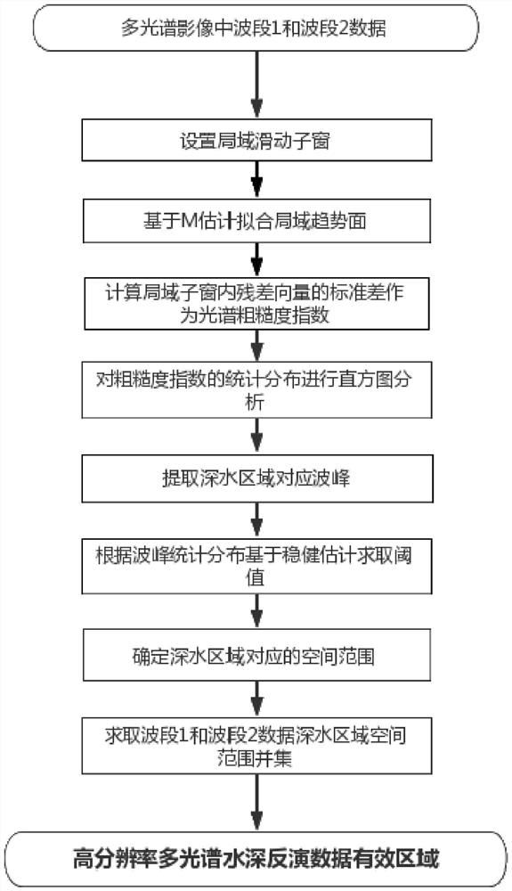
[0067] A method for judging the validity of high-resolution multispectral water depth inversion data based on spectral roughness information, such as figure 1 As shown, based on the band 1 (blue band) data and band 2 (green band) data in the high-resolution multispectral image, the roughness spatial distribution map is generated, and the spectral roughness index is statistically analyzed to delineate the The optical deep water area in each band is combined to determine the effective area of ​​high-resolution hyperspectral water depth data, which specifically includes the following steps:

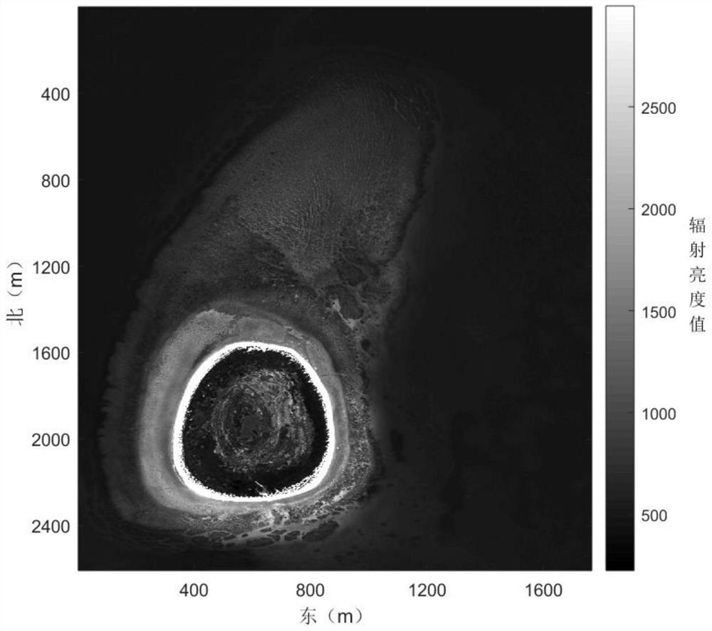
[0068] Step 1. Obtain a high-resolution multispectral image. Select band 1 and band 2 in the multispectral image. Band 1 is as follows figure 2 As shown, the local sliding sub-window with size p is set in band 1 and band 2 respectively,...


PUM


Abstract

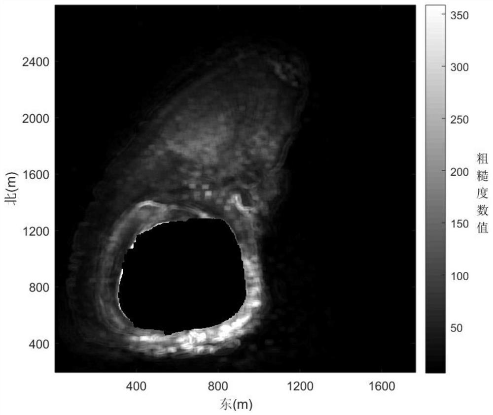
The invention discloses a method for judging validity of high-resolution multispectral water depth inversion data based on spectral roughness information, and relates to the field of marine surveying and mapping. The method comprises the following steps: selecting a plurality of wavebands in a multispectral image to set local sliding sub-windows, fitting a spectral trend surface based on an M robust estimation algorithm, respectively calculating a standard deviation of a residual vector in each local sliding sub-window to obtain a spectral roughness index, drawing a spectral roughness characteristic graph, and analyzing the distribution characteristics of the spectral roughness index to obtain the spectral roughness of the multispectral image. Extracting the distribution range of wave crests in the optical deepwater area, determining the spatial distribution of the optical deepwater area in the multispectral image, combining the optical deepwater area in each wave band of the multispectral image, and determining the effective area of the multispectral remote sensing inversion water depth. According to the method, the effectiveness of the high-resolution multispectral water depth inversion data can be directly judged without actually measured water depth data from spectral data, and the method has important application value in the fields of marine surveying and mapping, marine remote sensing and marine information.

Description

technical field [0001] The invention relates to the technical fields of ocean surveying and mapping and ocean remote sensing, in particular to a method for judging the validity of high-resolution multispectral water depth inversion data based on spectral roughness information. Background technique [0002] The depth retrieval technology using multispectral remote sensing appeared in the second half of the 20th century. With the rapid development of vehicles and sensors, the effect of multispectral remote sensing depth retrieval has been significantly improved. Multispectral images can be obtained by satellites or flying chess with extremely high measurement efficiency. The development of measurement tools has significantly improved the acquisition efficiency of coastal water depth information, and has broad application prospects in coastal ocean detection. Using multispectral images for water depth reflection It has become a research hotspot in recent years. [0003] Howeve...

Claims


Application Information

Patent Timeline
Patent Type & Authority Applications(China)
IPC IPC(8): G01C13/00G06V10/58
CPCG01C13/008Y02A90/30
Inventor 张凯王燕茹张利勇王鑫
Owner SHANDONG UNIV OF SCI & TECH
Learn More