Labeling method for road image ground marking

An image and marking technology, which is applied in the field of labeling of road image ground markings, can solve problems such as time-consuming and laborious, difficult to guarantee labeling accuracy, and slow labeling speed, so as to improve labeling speed and accuracy, reduce labeling difficulty, and adaptability strong effect

Pending Publication Date: 2022-05-13
中智行(苏州)科技有限公司
View PDF7 Cites 0 Cited by
  • Summary
  • Abstract
  • Description
  • Claims
  • Application Information

AI Technical Summary

Problems solved by technology

[0003] At present, the existing technology adopts a pixel-by-pixel manual marking method for ground marking lines such as lane lines. The object of marking is to directly mark a pixel center line, or mark two side edge lines, or mark the outer contour of the entire marking line, one by one. The method of manually labeling pixels is very slow. In order to mark the accuracy, the image needs to be enlarged first, and then accurately manually select points pixel by pixel. Labeling an image

Method used


Image

  • Labeling method for road image ground marking
  • Labeling method for road image ground marking
  • Labeling method for road image ground marking

Examples


Embodiment Construction

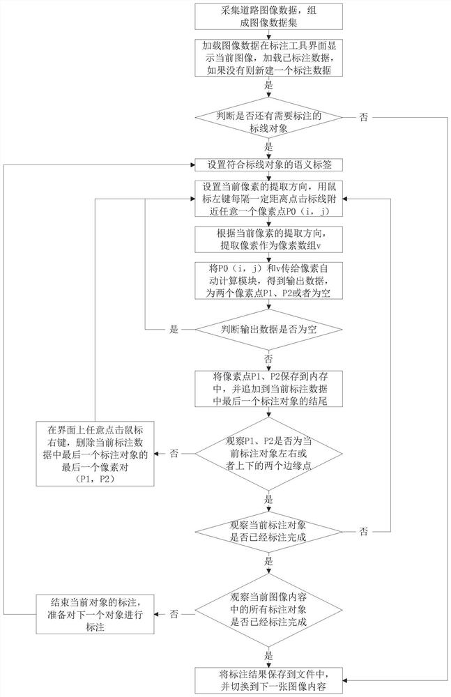
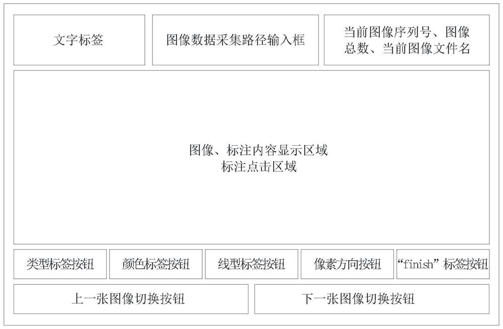
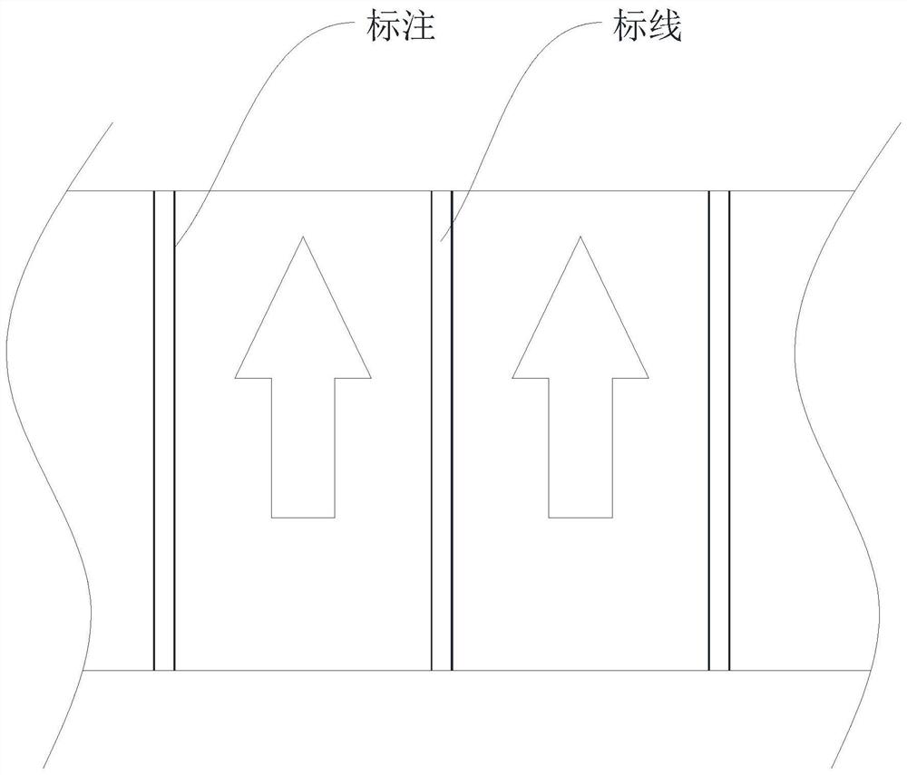
[0068] This embodiment provides a method for labeling road image ground markings. The overall process is to first collect image data on the road, and the collection method is to use a camera to shoot images on the road, usually at a certain distance. Ensure that each image is not exactly the same, and avoid repeated shooting at the same position and angle. In addition, the subject of the shooting is the road, so it needs to be photographed on the ground, not completely facing the sky. The collected images are put together to form an image dataset. ;Secondly, use the annotation tool to perform image-by-image annotation operations on the image data set. The specific annotation process is to load the images one by one, display each image on the screen with a fixed zoom ratio, and then observe and judge the image by the annotator with naked eyes in the content, such as image 3 As shown, the marking lines in the image are marked one by one. After the marking of each image is compl...


PUM


Abstract

The invention discloses a road image ground marking method, relates to the technical field of vehicle automatic driving, and can quickly and accurately mark pixel geometric information of a road marking in an image when a large amount of image data is marked. According to the semi-automatic marking method, the edge points on the two sides of the marking line can be automatically obtained only by clicking any point near the pixel of the marking line, the complete pixel geometric information of the whole marking line can be obtained after multiple times of continuous clicking, accurate manual pixel point-by-pixel selection is not needed, the semi-automatic marking method greatly reduces the marking difficulty, and the marking efficiency is improved. The marking speed and precision are greatly improved; besides, the method is higher in adaptability, not only can be used for marking transverse marking lines in the image, but also can be used for marking longitudinal marking lines in the image, not only can be used for marking lane lines, but also can be used for marking various ground marking lines such as stop lines, pedestrian crossing lines and guide lines, and not only can be used for marking white marking lines, but also can be used for marking yellow marking lines.

Description

technical field [0001] The invention relates to the technical field of vehicle automatic driving, in particular to a method for labeling road image ground markings. Background technique [0002] High-precision maps are an essential part of current driverless technology, and ground marking data such as lane lines are the core content of high-precision maps. Vehicles usually need to travel along the centerline of the lane determined by the two lane lines in the high-precision map. Automatic driving, so ground markings such as lane lines play a very important role in the functions of each module of unmanned driving. It is often necessary to identify the exact position of the lane line very accurately. In order to achieve these goals, a large amount of lane line image annotation data is required , used to provide learning for the algorithm model and improve algorithm capabilities. [0003] At present, the existing technology adopts a pixel-by-pixel manual marking method for gro...

Claims


Application Information

Patent Timeline
IPC IPC(8): G01C21/36G01C21/34
CPCG01C21/3632G01C21/3658G01C21/3484
Inventor 黄洁赵灿王劲
Owner 中智行(苏州)科技有限公司
Why Eureka
Try Eureka