Natural resource base map construction method based on data fusion

A natural resource and data fusion technology, applied in data processing applications, image data processing, 2D image generation, etc., can solve the problem of no judgment method and operation method, avoid all repeated searches, fast search, reduce The effect of the number of searches

Active Publication Date: 2022-05-27
江苏省基础地理信息中心
View PDF5 Cites 2 Cited by
  • Summary
  • Abstract
  • Description
  • Claims
  • Application Information

AI Technical Summary

Problems solved by technology

The relevant technical schemes promulgated by the state only propose technical indicators and basic operating principles, but do not give specific judgment methods and operating methods

Method used


Image

  • Natural resource base map construction method based on data fusion
  • Natural resource base map construction method based on data fusion
  • Natural resource base map construction method based on data fusion

Examples


Embodiment 1

[0054] Example 1 takes The Hengliang Street of Liuhe District of Nanjing City as an example, the technical solution of the present invention is further described in detail.

[0055] The scheme of this application is suitable for the construction of a basemap of woodland, wetland, and grassland, and only the key attribute fields are different when used, and the first threshold and the second threshold are the same.

[0056] The present invention refers to a professional survey data of natural resources, determined according to the type of natural resources, for example, for forest resources data, the natural resources professional survey data refers to forest resources category II survey data.

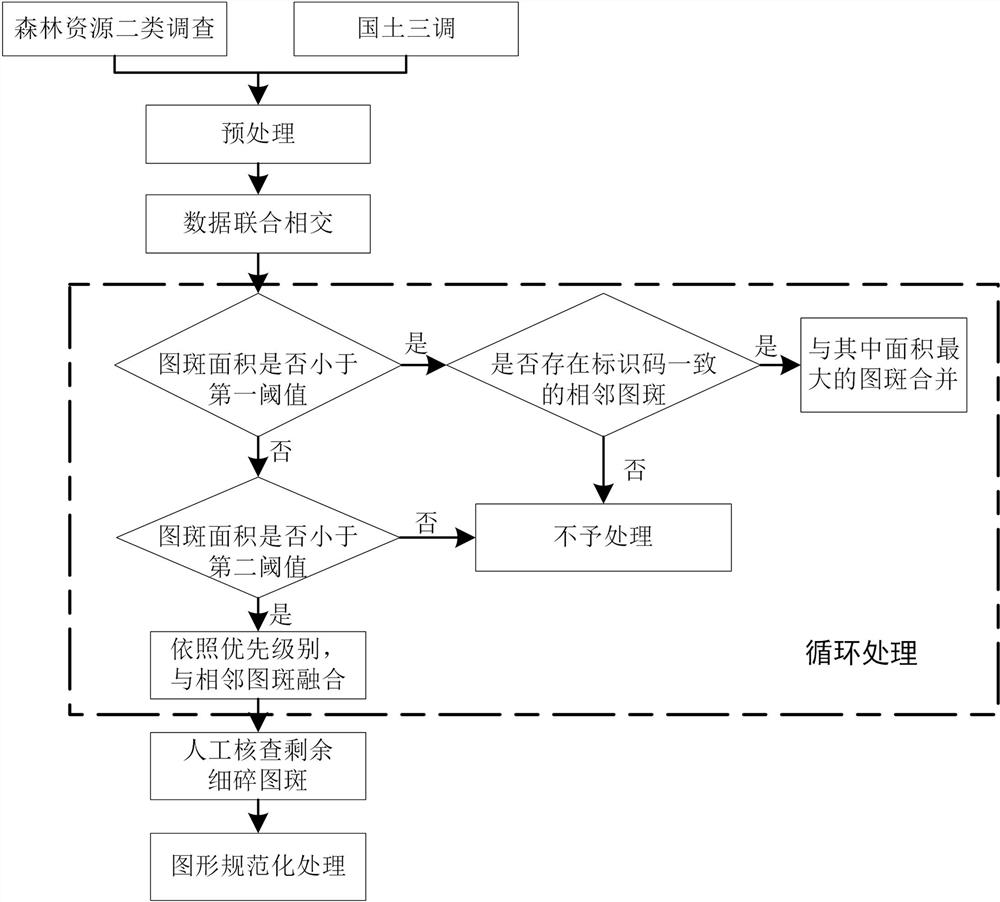
[0057] The data processing environment includes geographic information system software ArcGIS 10.1, and Python IDLE; the method flow of the present invention such as Figure 1 as shown.

[0058] Step 1: Data preprocessing

[0059] 1.1 Import the DLTB layers from the Liuhe District Forest Res...


PUM


Abstract

The invention provides a natural resource base map construction method based on data fusion. Based on territorial three-tone data and natural resource professional survey data, after data preprocessing and joint intersection, fused data considering graphs and attributes of the territorial three-tone data and the natural resource professional survey data is obtained. Aiming at small image spots of which the area is less than a first threshold value and the area is between the first threshold value and a second threshold value in the intersected data, searching an optimal to-be-fused image spot based on a list and rule method combination, screening out candidate objects of the to-be-fused image spots by taking consistent identification codes as a first screening rule, putting the candidate objects into a list, and according to a second screening rule, selecting the candidate objects of the to-be-fused image spots from the candidate objects of the to-be-fused image spots. And screening the candidate objects step by step according to the priority of the judgment criterion to realize rapid and automatic data fusion. According to the fusion method, the optimal to-be-fused pattern spots can be automatically and efficiently searched, and the broken and small pattern spots are eliminated through fusion, so that a natural resource base map meeting natural resource investigation and monitoring requirements is obtained.

Description

Technical field [0001] The present invention belongs to the field of geographic information and data identification technology, specifically relates to a basemap construction method based on data fusion of natural resources. Background [0002] With the institutional reform in 2018, "mountains, water, forests, fields, lakes, grasses and seas" will be unified into the management of the Ministry of Natural Resources from the national level, forming an integrated management pattern of natural resources. For a long time, the definition and collection standards of resources such as woodland, wetlands and grasslands in different departments have been inconsistent, resulting in large differences in survey data. Under the situation of unified natural resource survey and monitoring, it is urgent to integrate various types of resource data based on the data of the Third National Land Survey (hereinafter referred to as "Land Three Adjustment Data"),so as to lay the foundation for a base map...

Claims


Application Information

Patent Timeline
Patent Type & Authority Applications(China)
IPC IPC(8): G06T11/00G06Q50/26
CPCG06T11/00G06Q50/26Y02D10/00
Inventor 陈超李梦梦虞瑶陶旸潘九宝赫春晓
Owner 江苏省基础地理信息中心
Why Eureka
Try Eureka