Low-altitude remote sensing image rapid and automatic splicing method without POS assisting

A low-altitude remote sensing and automatic stitching technology, applied in image enhancement, image analysis, image data processing and other directions, can solve the problem of inability to meet the practical application of low-altitude remote sensing images, achieve processing efficiency and stability guarantee, and meet the requirements of quasi-real-time processing. Effect

Active Publication Date: 2014-07-16
WUHAN UNIV
View PDF2 Cites 29 Cited by
  • Summary
  • Abstract
  • Description
  • Claims
  • Application Information

AI Technical Summary

Problems solved by technology

In recent years, panoramic image stitching technology based on computer vision theory has been developed rapidly. Although this fast stitching technology does not require POS data, camera parameters, etc., experiments have shown that this panoramic image stitching technology can only handle dozens of close-range images. , completely unable to meet the practical application of hundreds or thousands of low-altitude remote sensing images

Method used


Image

  • Low-altitude remote sensing image rapid and automatic splicing method without POS assisting
  • Low-altitude remote sensing image rapid and automatic splicing method without POS assisting
  • Low-altitude remote sensing image rapid and automatic splicing method without POS assisting

Examples


Embodiment Construction

[0050] The technical solution of the present invention will be further described below in conjunction with the accompanying drawings.

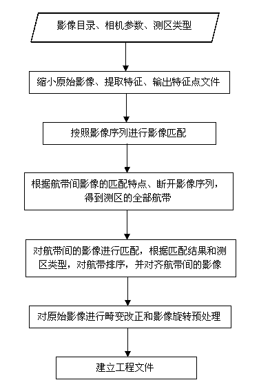
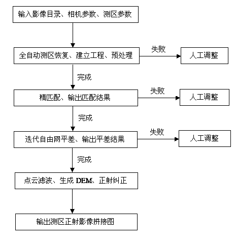
[0051] The method of the invention firstly matches the original low-altitude remote sensing image sequence, and realizes automatic restoration of the measurement area without the assistance of POS; then, according to the traditional digital photogrammetry production process, the low-altitude remote sensing image orthophoto mosaic is automatically produced.

[0052] See figure 1 , the automatic recovery of low-altitude remote sensing images without POS assistance proposed by the present invention mainly includes steps:

[0053] (1) Input the original low-altitude remote sensing image sequence directory, camera parameters and survey area parameters.

[0054] The input original low-altitude remote sensing image sequence needs to be arranged according to the flight trajectory when the image was shot. Survey area parameters include image horizont...


PUM


Abstract

The invention discloses a low-altitude remote sensing image rapid and automatic splicing method without POS assisting. The method comprises the first step of full-automatic restoration of a low-altitude remote sensing image test area, the second step of conducting fine matching on a preprocessed image according to fine matching seed points to obtain a fine matching result, the third step of conducting free network adjustment iteration on the fine matching result to obtain an adjustment result, and the fourth step of conducting interpolation to generate a digital ground model of the image according to the adjustment result, obtaining a relative outer orientation element of the image under the free network coordinate system according to the adjustment result, conducting orthographic rectification on the image based on the digital ground model and the relative outer orientation element, and meanwhile generating an orthographic image splicing image of the test area. The method is free of POS data assisting, the orthographic image splicing image can be rapidly produced in a full-automatic mode, the remote sensing image quasi real-time processing requirement can be met, and the method is suitable for the fields of disaster emergency response, military security and the like.

Description

[0001] technical field [0002] The invention belongs to the field of surveying and mapping science and technology, and relates to a fast and automatic splicing method of low-altitude remote sensing images without POS assistance, which is mainly applied to data processing of low-altitude remote sensing images. Background technique [0003] Aerial remote sensing image data has been widely used in urban planning, land resources, surveying and mapping, agriculture, forestry, transportation, environmental protection and other fields. In response to natural disasters such as earthquakes, floods, and fires, as well as national security emergencies, faster, real-time, and more accurate data and products are needed, and mid- and low-altitude remote sensing images will play a leading role. Medium and low-altitude unmanned aerial vehicle is an effective means to quickly obtain high-resolution and high-precision remote sensing images. The accuracy of the POS (Airborne Positioning and ...

Claims


Application Information

Patent Timeline
Patent Type & Authority Applications(China)
IPC IPC(8): G06T5/50G06T7/00
Inventor 张永军秦守鹏段延松张祖勋黄旭鲁一慧
Owner WUHAN UNIV
Why Eureka
Try Eureka