
Multi-scale grid remote sensing data subdivision method and remote sensing data management method

A remote sensing data, multi-scale technology, used in special data processing applications, database indexing, structured data retrieval, etc. and other problems, to achieve the effect of improving representation accuracy and efficiency

Pending Publication Date: 2022-06-24
西安艾可萨科技有限公司
View PDF0 Cites 0 Cited by
  • Summary
  • Abstract
  • Description
  • Claims
  • Application Information

AI Technical Summary

Problems solved by technology

[0004] However, the current remote sensing data subdivision methods cannot adapt to remote sensing data with different data volumes, and the representation accuracy of remote sensing data is low, that is, the coverage of the grid and the coverage of spatial data are relatively low, which leads to the gap between data indexing and query. Efficiency, low precision

Method used


Image

  • Multi-scale grid remote sensing data subdivision method and remote sensing data management method
  • Multi-scale grid remote sensing data subdivision method and remote sensing data management method
  • Multi-scale grid remote sensing data subdivision method and remote sensing data management method

Examples


Embodiment 1

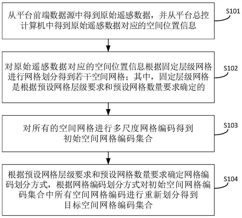
[0046] First, in order to improve the representation accuracy of gridded remote sensing data, see figure 1 , the embodiment of the present invention provides a multi-scale grid remote sensing data segmentation method, comprising the following steps:

[0047] S101. Obtain original remote sensing data from the front-end data source of the platform, and obtain the spatial position information corresponding to the original remote sensing data from the platform master control computer.

[0048]Specifically, the embodiment of the present invention obtains the original remote sensing data through the platform front-end data source. For example, the platform front-end data source may obtain the original remote sensing data from the on-board camera and store it on the satellite, but it is not limited to the acquisition method of the on-board camera. The original remote sensing data can also be obtained through unmanned aerial vehicles, aerospace equipment, etc. Correspondingly, auxilia...


PUM


Abstract

The invention discloses a multi-scale grid remote sensing data subdivision method and a remote sensing data management method, and the subdivision method comprises the steps: obtaining original remote sensing data from a platform front-end data source, and obtaining spatial position information corresponding to the original remote sensing data from a platform master control computer; performing grid division on the spatial position information corresponding to the original remote sensing data according to the fixed-level grid to obtain a plurality of spatial grids; performing multi-scale grid coding on all the space grids to obtain an initial space grid coding set; and determining a grid code division mode according to a preset grid hierarchy requirement and a preset grid number requirement, and re-dividing all the space grid codes in the initial space grid code set according to the grid code division mode to obtain a target space grid code set. According to the method, the remote sensing data is represented under multiple scales, the representation precision of the remote sensing data is improved, and the indexing and querying efficiency and accuracy of the remote sensing data are improved.

Description

technical field [0001] The invention belongs to the technical field of remote sensing data processing, and in particular relates to a multi-scale grid remote sensing data division method and a remote sensing data management method. Background technique [0002] With the continuous enrichment of earth observation technology and the continuous improvement of the ability to obtain spatial information, the remote sensing data obtained by people is extremely rich, and the richness of data is accompanied by the demand for fast data services. In spatial information processing, the storage management of remote sensing data is very important. [0003] In spatial information processing, the remote sensing data is always gridded as needed to form grid data, and then the remote sensing data storage management is carried out. In the grid-based satellite data storage management method, a core step is to use a spatial grid set to describe satellite remote sensing data, also known as grid ...

Claims


Application Information

Patent Timeline
Patent Type & Authority Applications(China)
IPC IPC(8): G06F16/22
CPCG06F16/2282
Inventor 朱荣臻张琴芳
Owner 西安艾可萨科技有限公司
Learn More