InSAR deformation monitoring result interpretation method for landslide

A technology of result interpretation and deformation, applied in the field of interpretation of InSAR deformation monitoring results for landslides, can solve the problems that affect the boundary delineation of landslides and fail to form effective observations, and achieve the effect of promoting application

Active Publication Date: 2022-07-26
RAILWAY ENG RES INST CHINA ACADEMY OF RAILWAY SCI +2
View PDF7 Cites 7 Cited by
  • Summary
  • Abstract
  • Description
  • Claims
  • Application Information

AI Technical Summary

Problems solved by technology

At the same time, affected by the orbital direction of the satellite and the side-view imaging angle of the sensor, some areas in the InSAR observation results may not have effective observations, which will affect the delineation of the landslide boundary

Method used


Image

  • InSAR deformation monitoring result interpretation method for landslide
  • InSAR deformation monitoring result interpretation method for landslide
  • InSAR deformation monitoring result interpretation method for landslide

Examples


Embodiment Construction

[0043] Exemplary embodiments of the present disclosure will be described in more detail below with reference to the accompanying drawings. While exemplary embodiments of the present disclosure are shown in the drawings, it should be understood that the present disclosure may be embodied in various forms and should not be limited by the embodiments set forth herein. Rather, these embodiments are provided so that the present disclosure will be more thoroughly understood, and will fully convey the scope of the present disclosure to those skilled in the art.

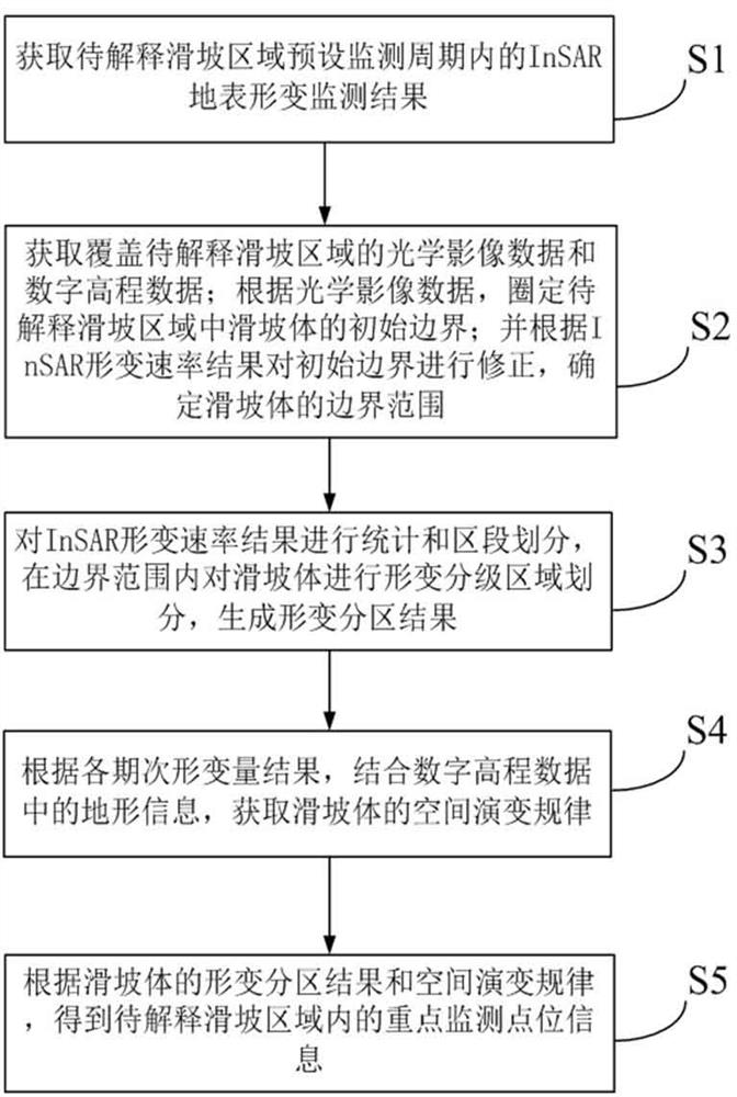
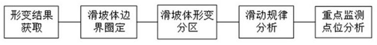
[0044] The embodiment of the present invention provides a method for interpreting InSAR deformation monitoring results for landslides, refer to figure 1shown, including the following steps:

[0045] S1. Obtain the InSAR surface deformation monitoring results within the preset monitoring period of the landslide area to be explained; the InSAR surface deformation monitoring results include: the InSAR deformation rate results ...


PUM


Abstract

The invention discloses an InSAR deformation monitoring result interpretation method for landslide, and the method comprises the steps: delineating an initial boundary of a landslide body through an optical remote sensing image, correcting the boundary through combining with an InSAR deformation rate monitoring result, and obtaining a boundary range of the landslide body through integration; within the boundary range, carrying out regional grading division on the landslide mass deformation degree by using an InSAR deformation rate result; obtaining a spatial evolution rule of the landslide mass based on the digital elevation data and the deformation quantity result of each stage; and determining key monitoring points of the landslide mass based on a deformation area grading result and spatial evolution rule information. The method can effectively extract information such as evolution rules of landslide boundaries and landslide disaster earth surface deformation in a monitoring area. Through grading the apparent deformation of the landslide disaster and analyzing the spatial evolution rule, the application of the traditional InSAR deformation monitoring technology in the landslide disaster evaluation work is promoted, and meanwhile, richer InSAR reference information is provided for the analysis of the evolution rule of the landslide disaster.

Description

technical field [0001] The invention relates to the technical field of landslide deformation monitoring, in particular to an InSAR deformation monitoring result interpretation method for landslides. Background technique [0002] Landslides are a common type of geological disasters in my country. The deformation monitoring of landslide bodies is of great significance for the prevention and control of landslide disasters. InSAR technology has the ability to carry out surface deformation monitoring in a large range, high precision, and non-contact. The monitoring of landslide mass is an important application field of InSAR deformation monitoring technology. The result obtained by InSAR technology is the deformation value of the monitoring area along the line of sight of the satellite, and the landslide disaster has the particularity that it is greatly affected by topographic factors, which directly affect the development, potential energy and sliding distance of the landslide. ...

Claims


Application Information

Patent Timeline
Patent Type & Authority Applications(China)
IPC IPC(8): G01B15/06G01S13/90
CPCG01B15/06G01S13/9023
Inventor 姚京川郭继亮简国辉张敬雷王佳琦袁慕策张勇梁志广胡在良刘伯奇邹友一冯楠郑佳怡
Owner RAILWAY ENG RES INST CHINA ACADEMY OF RAILWAY SCI
Why Eureka
Try Eureka