Mobile unit location by coherent processed satellite signal with fixed label signal

A mobile unit, signal technology, applied in the field of positioning system

Inactive Publication Date: 2003-06-18
CELLGUIDE
View PDF6 Cites 20 Cited by
  • Summary
  • Abstract
  • Description
  • Claims
  • Application Information

AI Technical Summary

Problems solved by technology

These prior art methods also rely on all BTSs being synchronized with each other, at least with each other if not with the GPS system

Method used


Image

  • Mobile unit location by coherent processed satellite signal with fixed label signal
  • Mobile unit location by coherent processed satellite signal with fixed label signal
  • Mobile unit location by coherent processed satellite signal with fixed label signal

Examples


Embodiment Construction

[0033] Description of the preferred embodiment

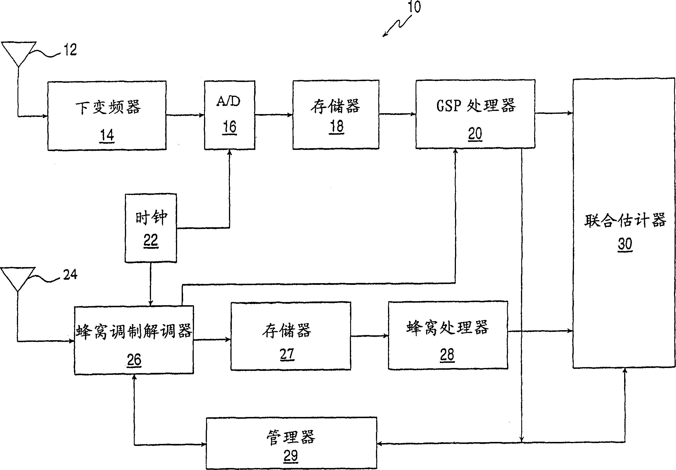
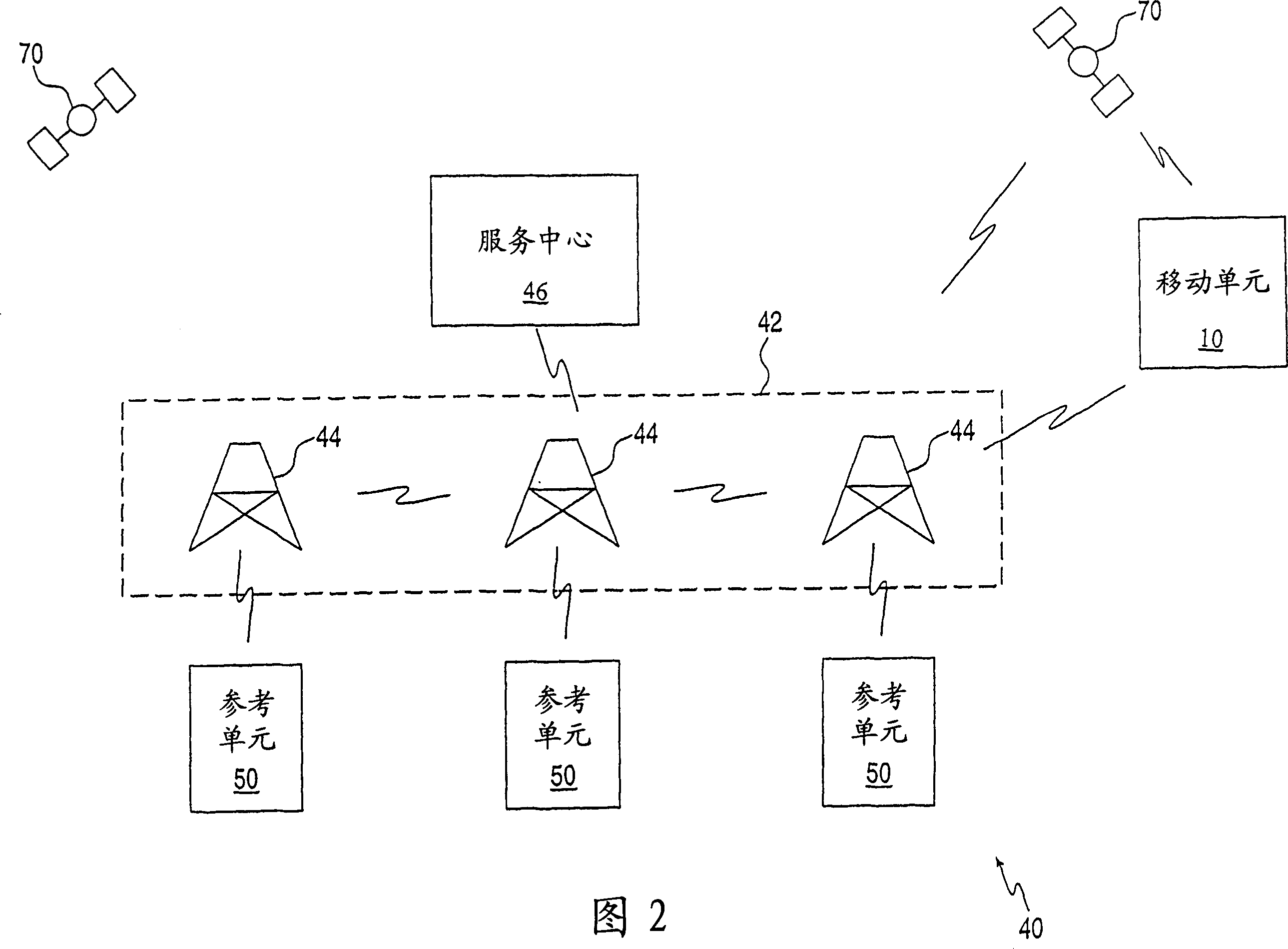
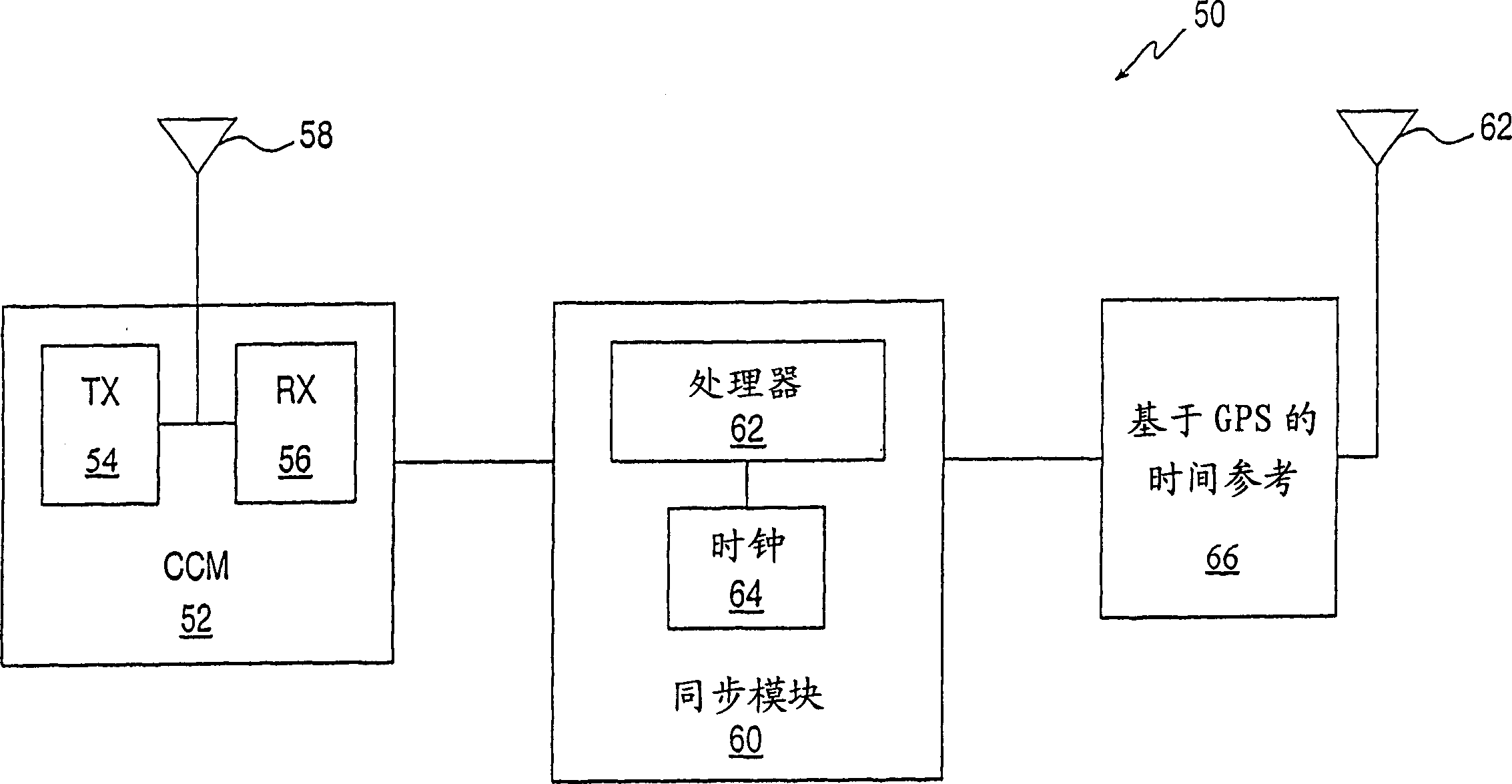
[0034] SUMMARY OF THE INVENTION The present invention is a system and method for locating a mobile unit, such as a wireless communication system, based on timing signals from mobile beacons, such as GPS satellites, and from stationary beacons, such as base stations of the wireless communication system. In particular, the present invention may be used to locate a suitably configured cellular telephone in an environment such as an urban area 20 where it is difficult to establish line of sight to four or more GPS satellites simultaneously.

[0035] Although the invention is described herein with reference to a GPS system and a cellular telephone network, it is to be understood that such description is purely illustrative, as stated above, the scope of the invention extends to the use of any suitable type of mobile and stationary beacons.

[0036] The principles and operation of the locator system and method according to the present...


PUM


Abstract

A method and system for finding the position of a mobile unit with respect to the satellites of a satellite network such as the Global Positioning System and with respect to the base stations of a wireless communications network. Each satellite transmits a signal that consists of a series of frames of a pseudonoise sequence. The frames of a signal received from the satellite network by the mobile unit are arranged as columns of a matrix and are processed coherently to provide estimated pseudoranges and estimated rates of change of pseudoranges for in view satellites. The coherent processing includes performing an orthogonal transform on the rows of the matrix, multiplying the elements of the matrix by Doppler compensation factors, and then, for each satellite in view, convolving the columns of the matrix with the pseudonoise sequence of that satellite. Other pseudoranges are inferred from synchronization burst sequences received by the mobile unit from one or more base stations. If the base stations are not mutually synchronized, reference units are provided to determine the time offsets between the base station clocks and the satellite network clock and to transmit these time offsets to the mobile unit, so that all the pseudoranges include the same bias relative to the satellite network clock. The pseudoranges are processed and reconciled by a dynamic estimator that includes a linear optimal estimator such as a Kalman filter, to produce successive estimates of the location of the mobile unit as the mobile unit moves.

Description

field of invention [0001] This invention relates to positioning systems for portable radio transceivers, and more particularly to positioning systems for a mobile unit in a wireless communication network based on signals from a satellite network such as the Global Positioning System (GPS) and from base stations of the wireless communication network. GPS. Background technique [0002] The Global Positioning System is a system of low-Earth orbit satellites that transmit standard signals that can be used to determine the location of a user equipped with an appropriate GPS receiver. For civilian use, the signal is "C / A coded", that is, a pseudorandom noise (PN) sequence transmitted at a chip rate of 1023KHz, and its repetition period is 1023 chips, so each frame of the PN sequence includes 1023 codes piece. Each satellite is assigned its unique PN sequence, and the PN sequences of individual satellites are mutually orthogonal. [0003] Superimposed on the PN sequence transmit...

Claims


Application Information

Patent Timeline
Patent Type & Authority Applications(China)
IPC IPC(8): G01S1/68G01S19/12G01S19/25G01S19/29H04W64/00
CPCG01S19/29G01S19/256G01S19/12G01S19/252G01S1/68
Inventor 约瑟夫·尼尔巴鲁赫·沙耶维特哈诺赫·科昂奥列格·佩雷尔穆特
Owner CELLGUIDE
Why Eureka
Try Eureka