Supercharge Your Innovation With Domain-Expert AI Agents!

Synchronous scanning terrestrial networks for measurements for crowdsourcing and positioning

a technology of crowdsourcing and positioning, which is applied in the field of synchronous scanning terrestrial networks for crowdsourcing and positioning measurements, can solve the problems of inability to provide or accurately locate sps in indoor locations, and compromise of database growth and maintenan

Active Publication Date: 2018-07-31
QUALCOMM INC
View PDF21 Cites 3 Cited by
  • Summary
  • Abstract
  • Description
  • Claims
  • Application Information

AI Technical Summary

Benefits of technology

This approach minimizes position errors and reduces wake-up power consumption by ensuring scans are aligned, enabling accurate indoor positioning and improving database growth and maintenance through synchronized terrestrial network data.

Problems solved by technology

Unfortunately, SPS positioning is often not available or inaccurate within indoor locations, where terrestrial based positioning is particularly useful.
Consequently, database growth and maintenance is compromised.

Method used


Image

  • Synchronous scanning terrestrial networks for measurements for crowdsourcing and positioning
  • Synchronous scanning terrestrial networks for measurements for crowdsourcing and positioning
  • Synchronous scanning terrestrial networks for measurements for crowdsourcing and positioning

Examples


Embodiment Construction

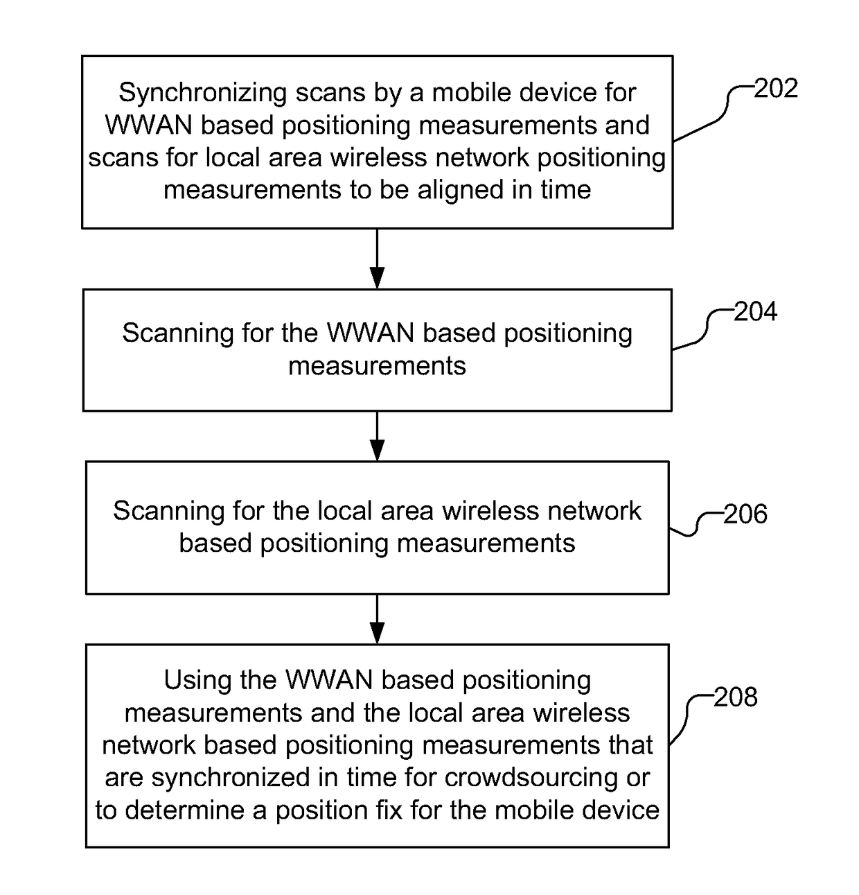
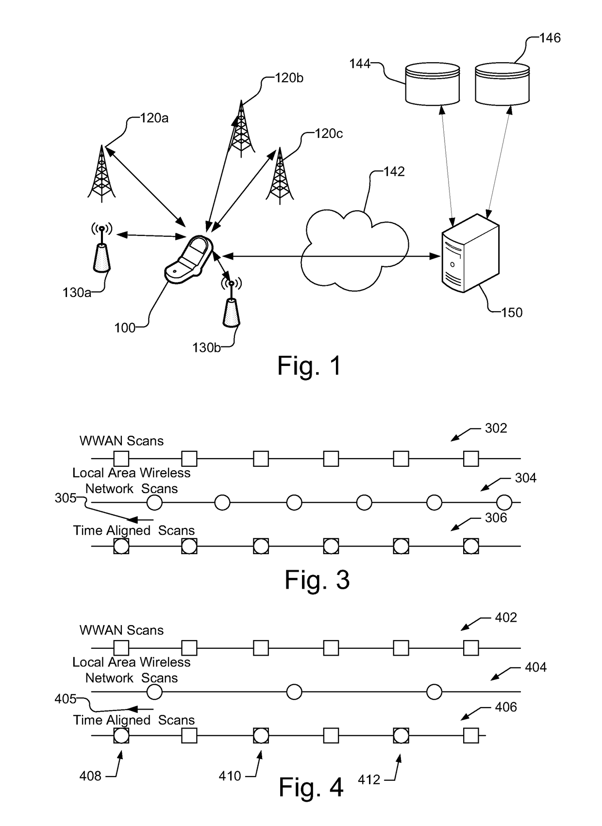
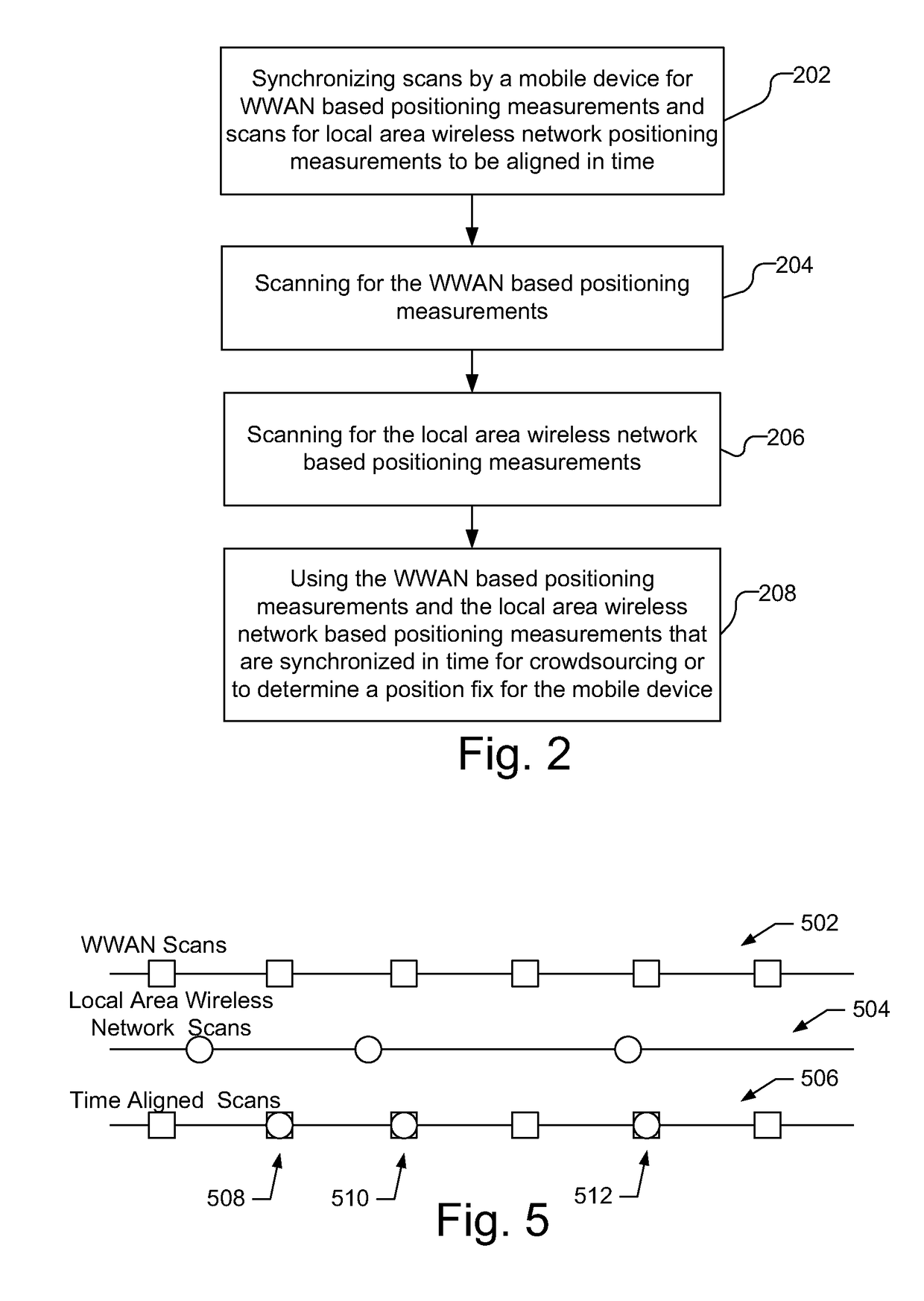
[0025]FIG. 1 illustrates mobile device 100 capable of wireless communication with terrestrial networks, including a wireless wide area network (WWAN) transmitters, illustrated as base stations 120a, 120b, and 120c (collectively referred to as base stations 120), as well as local area wireless network transmitters, illustrated as access points 130a and 130b (collectively referred to as access points 130). The local area wireless network as used herein includes wireless local area networks (WLANs) and wireless personal area network (WPANs) but does not include cellular networks or satellite networks. The mobile device 100 is capable of synchronously scanning for WWAN based positioning measurements, e.g., from base stations 120 and for local area wireless network based positioning measurements, e.g., from access points 130. As used herein, synchronous scanning indicates that the scans occur at substantially the same time, so that the scans are aligned in time. The synchronous scans by ...


PUM


Abstract

A mobile device synchronously scans different terrestrial networks for positioning measurements to align the scans in time. With minimal time difference between the scans, the positioning measurements from the different terrestrial networks may be used for crowdsourcing or position determination. The mobile device may synchronously scan a wireless wide area network (WWAN) and a local area wireless network so that positioning measurement derived from the scans are aligned in time. A local area wireless network is, e.g., a wireless local area networks (WLANs) or wireless personal area network (WPANs) but does not include cellular networks or satellite networks. The scans may be scheduled at a hardware level to ensure tight synchronization with near-zero time difference between the scans. Alternatively, the scans may be synchronized at a software level with only scans that occur within a time difference threshold from each other are used for crowdsourcing or positioning.

Description

BACKGROUNDBackground Field[0001]The subject matter disclosed herein relates to electronic devices, and more particularly to methods and apparatuses for use in or with a mobile device to synchronize scans from multiple terrestrial networks to obtain positioning measurements for crowdsourcing or to be used together for positioning and methods and apparatuses for crowdsourcing using data from synchronized scans.Relevant Background[0002]Obtaining accurate position information for mobile devices, such as cellular telephones or other wireless communication devices, is becoming prevalent in the communications industry. A common means to determine the location of a device is to use a satellite positioning system (SPS), such as the well-known Global Positioning Satellite (GPS) system or Global Navigation Satellite System (GNSS), which employ a number of satellites that are in orbit around the Earth. Other means commonly used to determine the location of a device includes terrestrial based po...

Claims


Application Information

Patent Timeline
Patent Type & Authority Patents(United States)
IPC IPC(8): H04W4/02H04L12/26H04W40/00H04W84/12
CPCH04W4/027H04W40/005H04L43/16H04W84/12H04W64/00H04W88/06G01S5/0263G01S2205/008G01S5/0264
Inventor PON, RAYMANDO, JU-YONG
Owner QUALCOMM INC
Features
  • R&D
  • Intellectual Property
  • Life Sciences
  • Materials
  • Tech Scout
  • Unparalleled Data Quality
  • Higher Quality Content
  • 60% Fewer Hallucinations
Learn More