Method of controlling soil moisture, water accumulation and fertilizer distribution in land

a technology of soil moisture and water accumulation, applied in the direction of programme control, instruments, sewage draining, etc., can solve the problems of adverse effects on crop yield, crop yield reduction, and crop yield reduction, so as to reduce the risk of accumulating water and improve crop growth potential

Active Publication Date: 2018-09-18
INT BUSINESS MASCH CORP
View PDF12 Cites 1 Cited by
  • Summary
  • Abstract
  • Description
  • Claims
  • Application Information

AI Technical Summary

Benefits of technology

[0007]According to an embodiment of the present principles, described herein is a computer-implemented method of controlling soil moisture and water accumulation in land. In the method, elevation data and location data for defined areas of land within a larger area of land are extracted from two or more pixels of a topographic image that includes topographic data, with each pixel corresponding to a defined area of land. The elevation and location data are employed in determining wetness indices for the defined areas of land based on a slope between two or more defined areas of land and an upslope contributing area per unit contour length for the defined areas of land. Based on the determined wetness indices, at risk defined areas of land that are at risk of accumulating water are identified. Water is transported from the at risk defined areas of land to another location. The determination of wetness indices is made in a hardware processer and the transporting of water reduces the risk of accumulating water in the at risk defined areas of land and improves crop growth potential in said areas.
[0009]Still further in accordance with present principles, described is computer program product for controlling soil moisture and water accumulation in land, the computer program product comprising a non-transitory computer readable storage medium having program instructions embodied therewith, the program instructions being executable by a computer to cause the computer to perform a method in which elevation data and location data for defined areas of land within a larger area of land are extracted from two or more pixels of a topographic image that includes topographic data, with each pixel corresponding to a defined area of land. The elevation and location data are employed in determining wetness indices for the defined areas of land based on a slope between two or more defined areas of land and an upslope contributing area per unit contour length for the defined areas of land. Based on the determined wetness indices, at risk defined areas of land that are at risk of accumulating water are identified. Water is transported from the at risk defined areas of land to another location. The determination of wetness indices reduces the risk of accumulating water in the at risk defined areas of land and improves crop growth potential in said areas.

Problems solved by technology

The amount of water retained by the soil may be related to achievable crop yield, whereas lack of water or excess water can reduce the yield.
Depending on the amount of water and evaporation from solar radiation, crop yield may be affected adversely.
Too much water accumulating on or in the land may adversely affect crop yield.
Such excessive water can lower crop yield.
In agriculture, too much water can be counterproductive by preventing root development, thereby inhibiting the growth of crops.
Too much water also can limit access to the land, particularly by farm machinery.
Operating heavy machinery on excessively wet soil may compact the soil to an extent that the soil becomes degraded and unusable for growing purposes.

Method used


Image

  • Method of controlling soil moisture, water accumulation and fertilizer distribution in land
  • Method of controlling soil moisture, water accumulation and fertilizer distribution in land
  • Method of controlling soil moisture, water accumulation and fertilizer distribution in land

Examples


Embodiment Construction

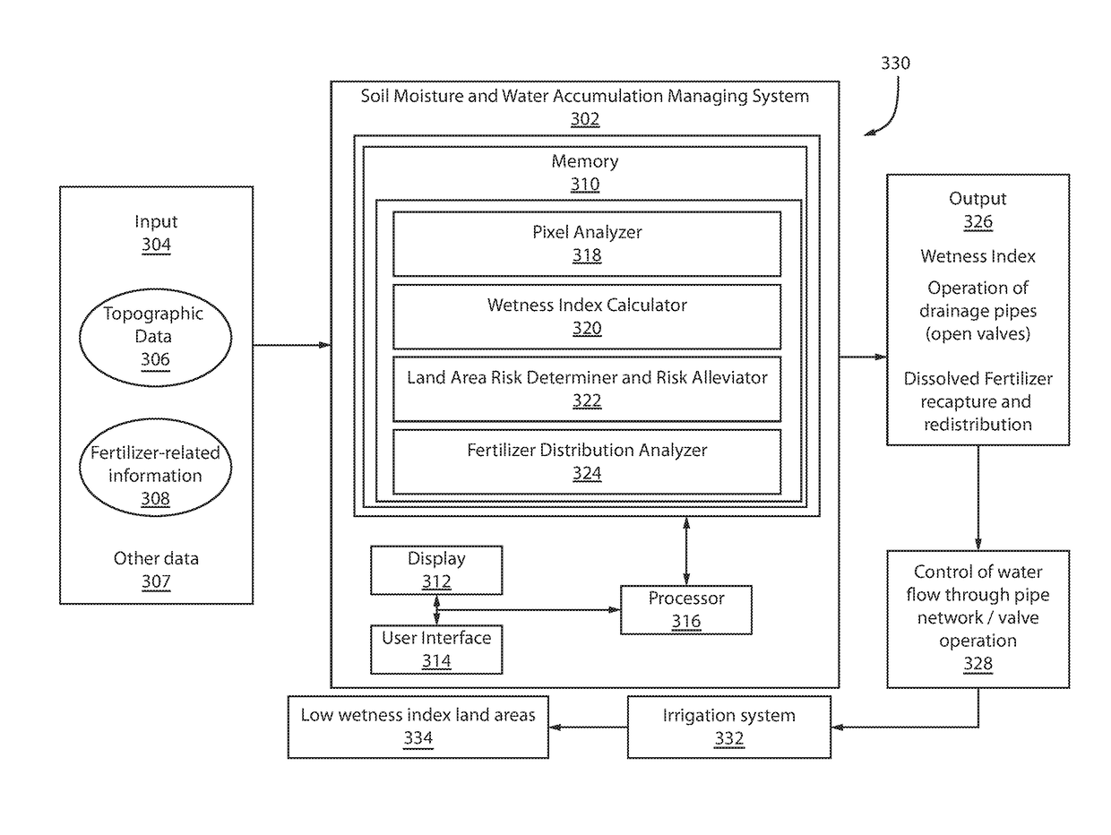
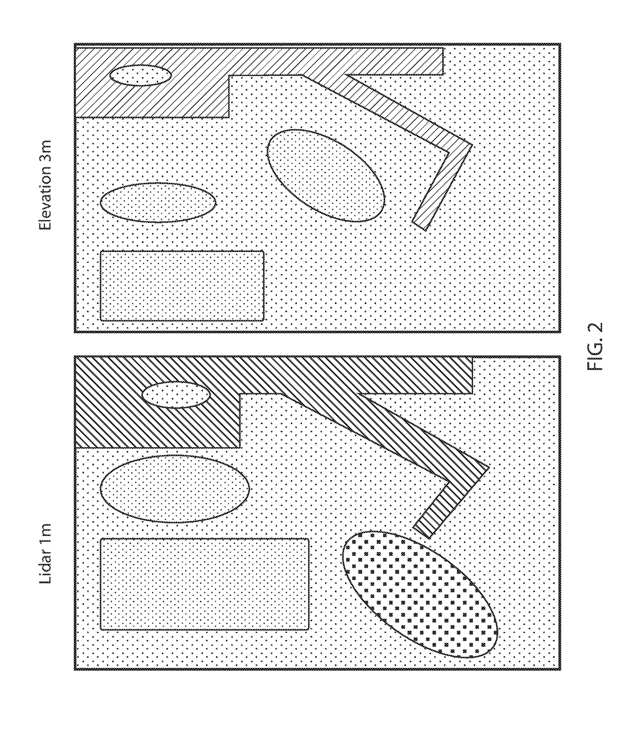
[0024]According to an embodiment of the present principles, described is a method in which topology of a plot of land is analyzed and determinations are made concerning the likelihood that water will accumulate on the surface of certain parts of the land and / or whether certain parts are likely to accumulation more water than would be beneficial. Topographic data for a plot of land is obtained. The topographic data may be an image in which the pixels of the image correspond to cells, e.g., discreet portions of land areas that have a size, e.g., an area, that is dependent on the resolution of the image. The slope between two or more adjacent areas of land is determined. Then, a wetness index is determined for the areas of land. If it is determined that, based on the wetness indices, that areas of land are at risk of accumulating water, then action is then taken. For example, a tiling system having a network of interconnected pipes and control valves configured to move water away from ...


PUM


Abstract

Described herein is a method of controlling soil moisture, water accumulation and fertilizer distribution in land. Elevation location data for land areas are extracted from two or more pixels of a topographic image including topographic data. Each pixel represents a land area. Wetness indices for the land areas are determined from the elevation and location data, based on the slope between two or more defined areas of land and an upslope contributing area per unit contour length. At risk defined areas of land, e.g., those at risk of accumulating water are identified based on wetness indices. Water is transported from the at risk defined areas of land to another location. The transporting of water reduces the risk of accumulating water in the at risk defined areas of land and improves crop growth potential in those areas.

Description

BACKGROUND[0001]Technical Field[0002]The present invention relates to a method of controlling soil moisture, water accumulation and fertilizer distribution in land. In particular, the present method employs topographic data to implement the control on farmland, where elevational differences may redistribute water and fertilizer.[0003]Description of the Related Art[0004]The topography of the land, the amount of water that falls on the land (e.g. through precipitation and irrigation), and soil properties factor into the amount of moisture that accumulate in the soil within a given land portion. Such considerations matter to the farmer and others involved in farm management. The orientation of farmland with regard to the position of the sun influences the amount of water removed from the soil by evaporation, which is another component of soil moisture variations across the land. The amount of water retained by the soil may be related to achievable crop yield, whereas lack of water or e...

Claims


Application Information

Patent Timeline
Patent Type & Authority Patents(United States)
IPC IPC(8): A01G25/16E03F1/00E02B11/00G05B19/042G06F17/30G06Q50/02G06Q10/06
CPCA01G25/167G06Q10/0635G06Q50/02G06F17/30241G06F17/30268G05B19/042G05B2219/2625G06F16/29G06F16/5866E02B11/005E03F1/00
Inventor CHITNIS, UPENDRA D.KLEIN, LEVENTEMARIANNO, FERNANDO J.
Owner INT BUSINESS MASCH CORP
Why Eureka
Try Eureka