Autonomous precision navigation

a technology of precision navigation and autonomous navigation, applied in the direction of navigation instruments, instruments, using reradiation, etc., can solve the problems of satellite constellation owner country degrading precision, affecting the accuracy of satellite navigation, and affecting the service availability, so as to enhance the traffic situational awareness of the crew and high measurement accuracy

Inactive Publication Date: 2018-10-09
DAS ADHIKARY AMIYA
View PDF1 Cites 4 Cited by
  • Summary
  • Abstract
  • Description
  • Claims
  • Application Information

AI Technical Summary

Benefits of technology

[0009]The primary object of this invention is to provide a self contained onboard multifunctional Navigation and control guidance System to eliminate external influences inducing error and reducing dependence on multiple external aids.

Problems solved by technology

Satellite based Navigation Systems also suffer from errors that can degrade its precision.
And of course, the satellite constellation owner country can degrade the precision and even suspend availability of service.
This is due to (i) high cost of equipment, (ii) mechanical parts hampering reliability in the form of wear, gimbals lock and ring lock (laser) and putting restriction on maneuver, (iii) requirement of position correction by input from other type of Navigation Systems during operation period to overcome integration drift.
Both the systems are unable to determine fluid (air and / or water) movement data in the vicinity of the vehicle through which the vehicle moves and effect of said fluid movement on vehicle movement which is a very important determinant for movement of vehicle through fluid (air and / or water).

Method used


Image

  • Autonomous precision navigation
  • Autonomous precision navigation
  • Autonomous precision navigation

Examples


Embodiment Construction

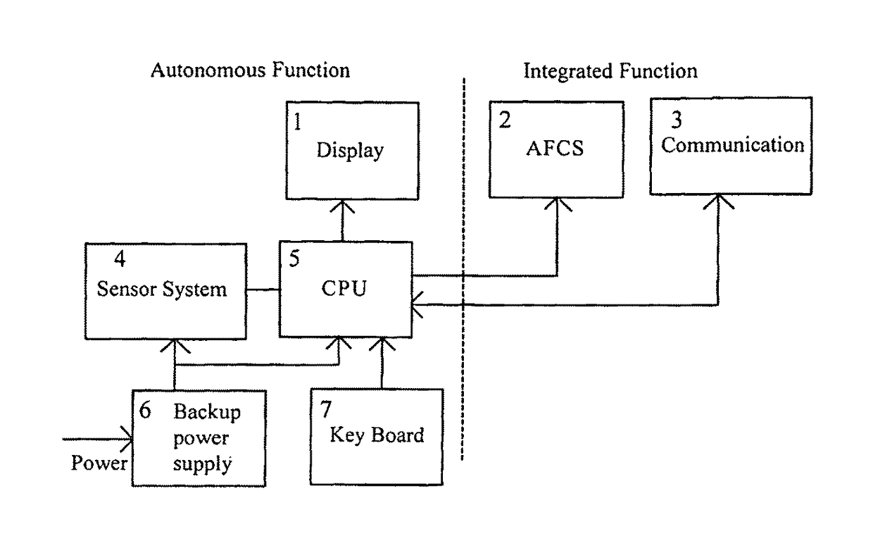
[0048]The system of new invention can be used in any type of vehicle (air, surface, marine, sub-marine or space). The sensor sub-system operation being same only computed Navigation Aid data and Control data will vary to cater for user specific requirement. Hence the embodiments for use in different types of vehicles will substantially be same.

The Preferred Embodiment

[0049]The acronym for Autonomous Precision Navigation is ‘APNA’ which, in Indian. National Language (Hindi) means ‘my own’. The method of this invention provides an onboard system which is truly ‘my own’ Navigation Aid for the mount vehicles. To understand the principle and application of the invention, embodiment for use in aircraft which the inventor calls ABLAN (Airborne Landing and Navigation) System will be explained. This embodiment is illustrated in the drawings and specific language will be used to describe the same.

[0050]Nevertheless, may it be understood that the scope of the invention is equally applicable to...


PUM


Abstract

The new invention is a method for a self-contained multifunctional navigation device. It computes 3D-Spatial velocity of the vehicle and of fluid medium surrounding the vehicle, using a movement sensor system comprising low power Transmitter and plurality of Receivers placed close to the Transmitter. The said computation measures propagation time delay of low frequency pulse envelope modulating carrier EM (radio) waves using Time to Digital Converter (TDC). Orientation, direction, position and movement data are derived using well known mathematical formulae. Derived movement data are displayed graphically on a Visual Display Screen. A commercial computer comprising real time operating system, stored digitalized Navigation data and digitalized map facilitates data computation and control and guidance. The method and movement sensor device can be used in any type of vehicle (airborne, surface, sub-surface, marine, sub-marine or space) as a means for navigation and control guidance aid.

Description

FIELD OF INVENTION[0001]This invention relates to a method and an on board self-contained multifunctional system for Navigation and Control of any type of vehicle (airborne, surface, sub-surface, marine, sub-marine or space) on which the system of this invention is mounted. In particular it relates to measuring spatial velocity along body fixed axes of the vehicle on which the system is mounted by measuring propagation time delay for a predetermined time frame pulse that modulates carrier wave & travels through space from a generating source (Transmitter) to multiple receivers each of which is placed on one of the principal axes (longitudinal, lateral and vertical) of the subject vehicle. Movement and orientation data with respect to geophysical plane are derived using the said spatial velocity and well known mathematical formulae. The instantaneous position, course and altitude are derived by dead reckoning (DR) from an initial setting. For vehicles moving through fluid (air and / or...

Claims


Application Information

Patent Timeline
Patent Type & Authority Patents(United States)
IPC IPC(8): G01C21/12G01C23/00G01S13/91G08G5/02G08G5/00
CPCG01C21/12G01C23/00G08G5/025G08G5/0021G08G5/0052G01S13/913
Inventor DAS ADHIKARY, AMIYA
Owner DAS ADHIKARY AMIYA
Why Eureka
Try Eureka