Marine chart and sonar image presentation systems and methods

a sonar image and marine technology, applied in the direction of direction/deviation determination system, using reradiation, instruments, etc., can solve the problems of affecting the commercial or recreational activities of the vessel, and affecting the use of the vessel

Active Publication Date: 2022-11-15
NAVICO HLDG
View PDF54 Cites 2 Cited by
  • Summary
  • Abstract
  • Description
  • Claims
  • Application Information

AI Technical Summary

Benefits of technology

[0009]Some embodiments of the present invention aim to provide useful information that will aid the user in determining and understanding the sonar coverage of the underwater environment. In some embodiments of the present invention, the sonar image may be presented on the nautical chart to visually indicate the sonar coverage. The orientation, sonar beam shape and size, and / or relative position of the sonar transducer with respect to watercraft may be accounted for in the presentation of the sonar image overlay presented on the chart.
[0011]In some example embodiments, the array(s) may be oriented such that the facing direction of the sonar image is generally outward of the watercraft. In such an example, the sonar image may extend in a horizontal plane, such as may correspond with the horizontal plane of a nautical chart. Accordingly, in some embodiments, the system may be configured to cause presentation of the live sonar image in the facing direction on the chart and relative to a representation of the watercraft so as to provide live sonar imagery on the chart to visually provide a relationship between objects within the live sonar imagery and a real-world position of the objects.
[0012]In some embodiments, the effective distance of the sonar coverage for the live sonar image may be accounted for during presentation on the chart. In this regard, the size of the sonar image on the chart may dimensionally correspond to the size of the sonar beam coverage within the underwater environment. Likewise, in some example embodiments, as the zoom level of the chart changes, the corresponding size of the sonar image presented thereon may also adjust to maintain the dimensional correspondence. In such examples, a user can more accurately understand where an object presented in the sonar image is in the real world. This may be useful for casting a fishing line or setting an anchor, among other things.
[0013]In some embodiments, the array may be rotatable with respect to the watercraft. Accordingly, the orientation of the sonar image of the chart with respect to the watercraft may be adjusted based on the current facing direction of the array. Additionally, in some embodiments, past sonar images can be maintained to help a user build-up a sonar image of the underwater environment (e.g., the user may build up a 360° view around the watercraft). In some embodiments, the past sonar images may fade away as time passes to create a visual indication of the older sonar imagery.

Problems solved by technology

It may be difficult and / or time consuming for the user to ascertain the condition of the body of water, which may detract from the commercial or recreational activities of the vessel.
As noted above, it can be difficult to determine the real world sonar coverage provided by the various sonar transducers of the watercraft.
The sonar beam shape (of the sonar beams emitting from the sonar transducer(s)) may be unknown or difficult to determine by the user, as well as the understanding of how that sonar beam shape fits within the underwater environment.
Accordingly, the corresponding coverage of the sonar beams may be difficult to understand, making it difficult to link the objects in the sonar imagery with their actual location within the body of water.

Method used


Image

  • Marine chart and sonar image presentation systems and methods
  • Marine chart and sonar image presentation systems and methods
  • Marine chart and sonar image presentation systems and methods

Examples


example architecture

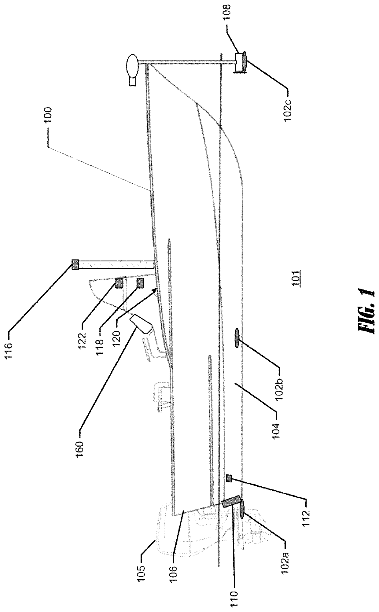
[0103]FIG. 19 illustrates a block diagram of an example system 400 according to various embodiments of the present invention described herein. The illustrated system 400 includes a marine electronic device 405. The system 400 may comprise numerous marine devices. As shown in FIG. 19, one or more sonar transducer assemblies 462 may be provided. A radar 456, a rudder 457, a primary motor 458, a trolling motor 459, and additional sensors / devices 460 may also be provided as marine devices, but other marine devices may be provided as well. One or more marine devices may be implemented on the marine electronic device 405. For example, a position sensor 445, a direction sensor 448, an autopilot 450, and other sensors 452 may be provided within the marine electronic device 405. These marine devices can be integrated within the marine electronic device 405, integrated on a watercraft at another location and connected to the marine electronic device 405, and / or the marine devices may be imple...


PUM


Abstract

Systems and methods for presenting marine information are provided herein. A system includes an array of a plurality of sonar transducer elements associated with a watercraft and a display. The system causes presentation of a chart of a body of water, including a representation of the watercraft at a current location. The system also operates the array to cause transmission of sonar beams into the underwater environment and receives sonar return data from the array. The system further generates, based on the sonar return data, a two-dimensional live sonar image, determines a facing direction of the array, and causes presentation of the sonar image in the facing direction on the chart and relative to the representation of the watercraft. Accordingly, live sonar imagery is presented on the chart to visually provide a relationship between objects within the live sonar imagery and the real-world position of those objects.

Description

CROSS-REFERENCE TO RELATED APPLICATION(S)[0001]This application is a continuation-in-part of U.S. Non-Provisional application Ser. No. 17 / 123,189, filed Dec. 16, 2020, entitled “Marine Electronic Device for Presentment of Nautical Charts and Sonar Images”, which is a continuation of U.S. Non-Provisional application Ser. No. 15 / 982,362, filed May 17, 2018, entitled “Marine Electronic Device for Presentment of Nautical Charts and Sonar Images”; the contents of each being hereby incorporated by reference in its entirety.FIELD OF THE INVENTION[0002]Embodiments of the present invention relate generally to presentation of marine data, and more particularly, to providing for improved display features regarding sonar data on nautical charts.BACKGROUND OF THE INVENTION[0003]Nautical charts including electronic or interactive nautical charts are typically used to provide a user with information about a body of water including (but not limited to) depth, routes, areas of interest, or the like....

Claims


Application Information

Patent Timeline
Patent Type & Authority Patents(United States)
IPC IPC(8): G01S3/801G01S3/802G06F3/041H04N1/00G06F3/0488G09B29/00G06F3/04845
CPCG01S3/801G01S3/802G06F3/0412G06F3/0488G06F3/04845G09B29/003H04N1/00411G01S7/521G01S15/89G01S7/6236G01S7/6272G01S7/629
Inventor CLARK, JEREMIAH D.
Owner NAVICO HLDG
Why Eureka
Try Eureka