Computerized national online parcel-level map data portal

a technology of online parcel level map and data portal, which is applied in the field of computerized national online parcel level map data portal, can solve the problem of limited data and the lik

Active Publication Date: 2003-07-24
BOUNDARY SOLUTIONS
View PDF9 Cites 76 Cited by
  • Summary
  • Abstract
  • Description
  • Claims
  • Application Information

AI Technical Summary

Problems solved by technology

In most instances, the desired data is usually limited to the agency's parcel boundaries and "geocode".

Method used


Image

  • Computerized national online parcel-level map data portal
  • Computerized national online parcel-level map data portal
  • Computerized national online parcel-level map data portal

Examples


Embodiment Construction

of Specific Methodologies

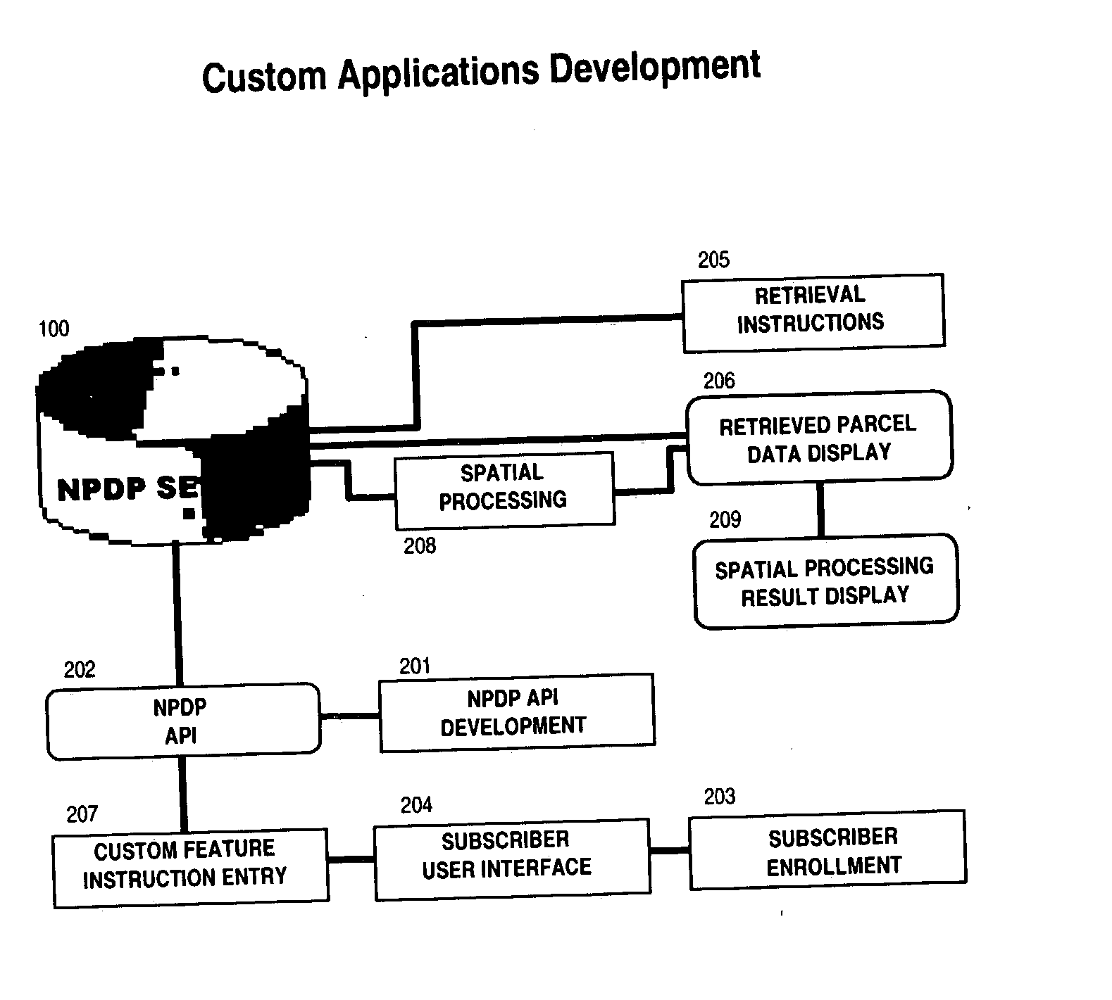
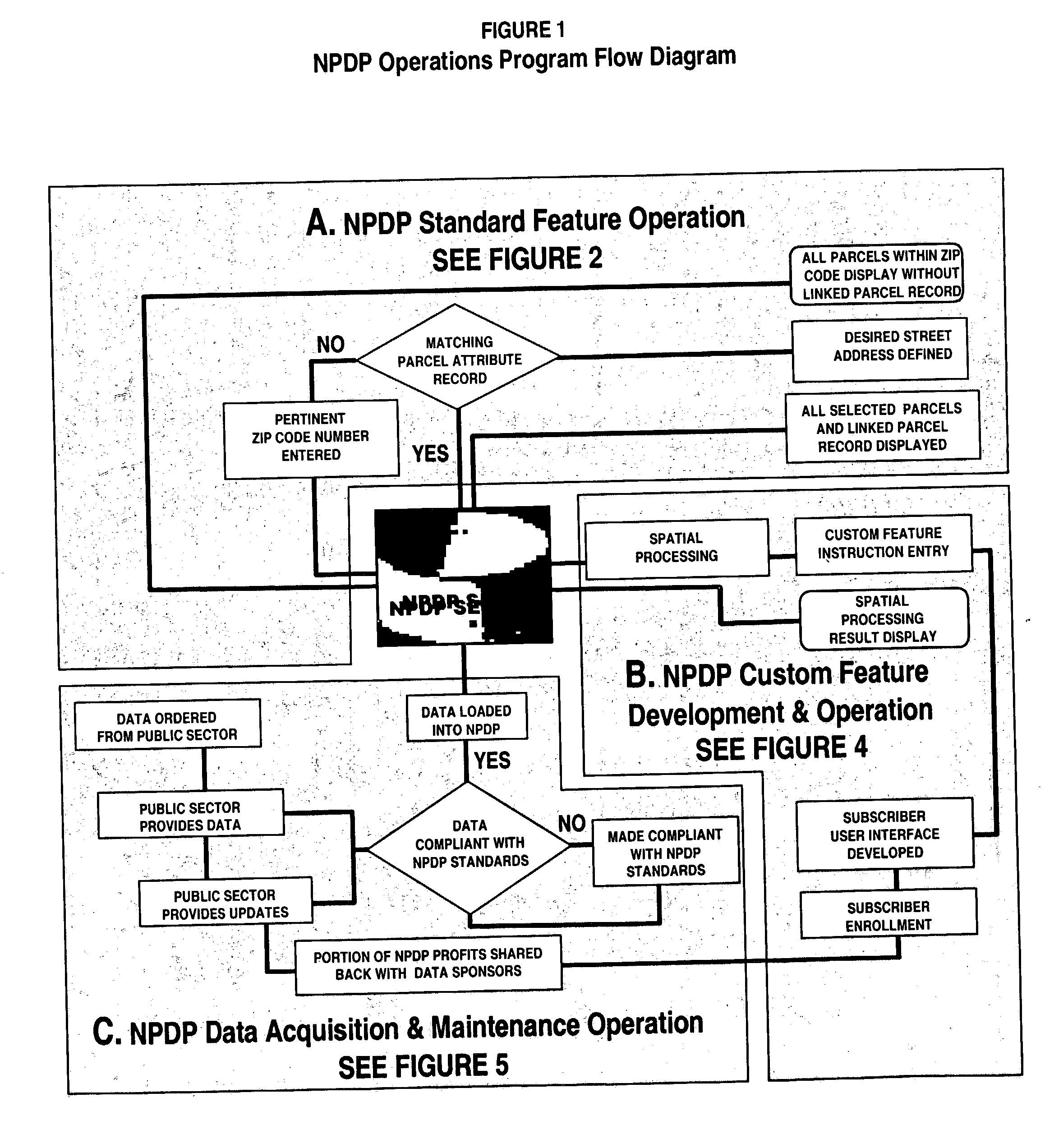
[0046] FIG. 1 provides an overview of the NPDP Development and Operations Program. The overall effort to establish and maintain the NPDP is broken up into three program development and maintenance components: (A) NPDP Standard Feature Operations, (B) NPDP Custom Feature Development & Operations, and (C) NPDP Data Acquisition and Maintenance Operations. Each of these operations will now be described with reference to FIGS. 2 to 5.

NPDP Standard Feature Operations

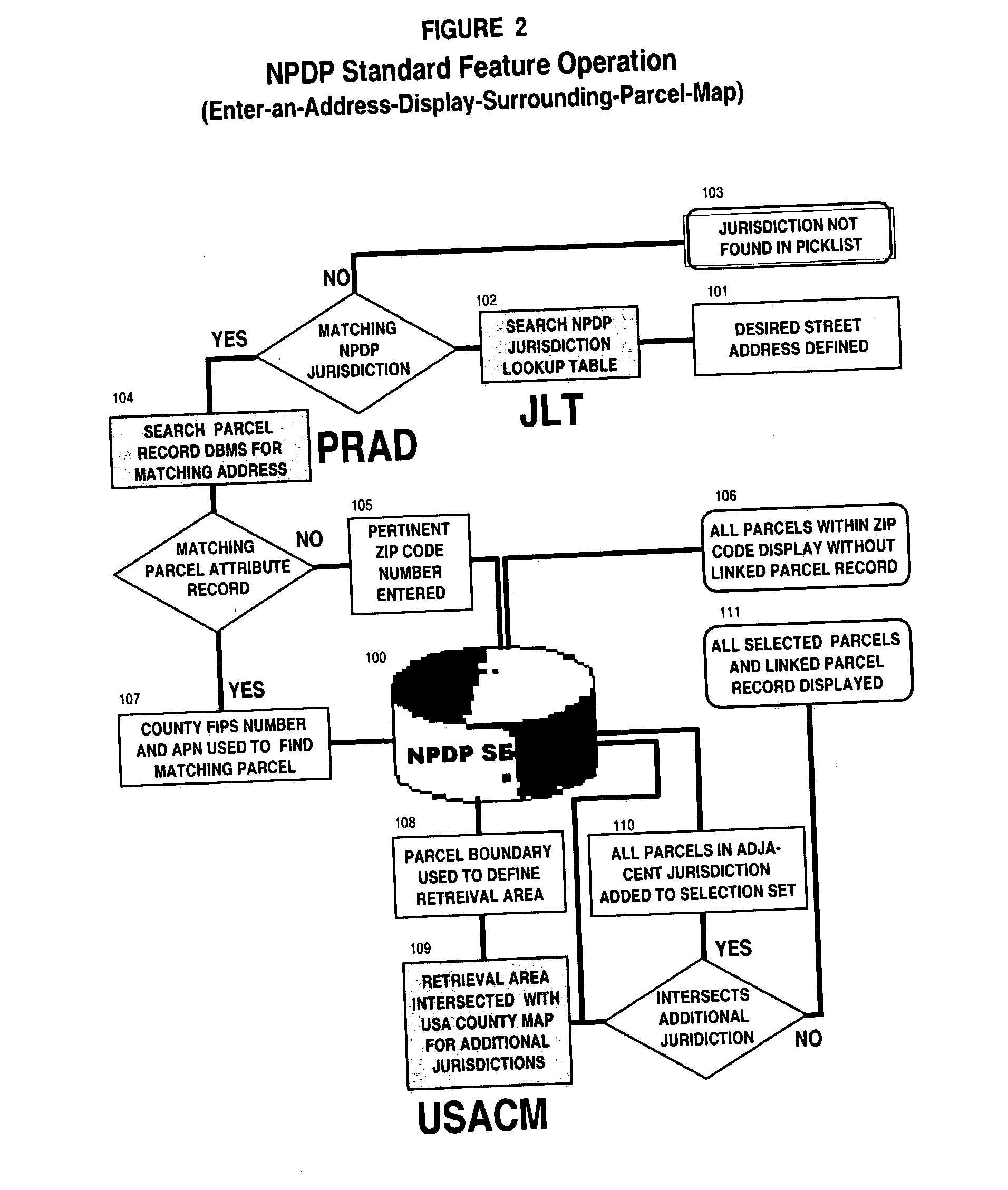
[0047] FIG. 2 provides a detailed explanation of the individual computerized steps involved for the NPDP to automatically perform its standard feature operation of retrieving a requested map area around a parcel based on an entered street address. The basic components of the NPDP standard feature operations are shown shaded in FIG. 2. FIG. 6 is a screen shot of a sample result of an address match.

[0048] The National Parcel-Level Map Data Portal Server (NPDP SERVER) 100 is constructed on an industry sta...


PUM


Abstract

A National Online Parcel-Level Map Data Portal (NPDP) is provided that optimizes online delivery of parcel-level maps and linked attribute data. To do this, the NPDP manages a database of assembled and current vector based parcel data in a spatial format (GIS) that enables geocoded parcel boundaries to be linked to property tax records. A user enters a street address into an appropriate screen window to call up and view road right-of-ways, all parcel boundaries and the "exact" address location as a highlighted parcel area. In addition, a list of property record attributes such as owner, use code, assessed value and year constructed can be displayed. Other on screen parcels can likewise be selected if one wishes to view their linked attributes. Subscribers may customize the NPDP to perform a variety of spatial analysis/reporting functions. Under public/private alliances, agreements are negotiated with individual property assessor's offices whereby they receive a portion of NPDP service provider revenue in return for parcel map database updates. Such on-going commerce between data sponsors and the NPDP service provider is utilized to assure a sustained and expanding flow of increasingly competent content.

Description

[0001] This application claims priority to U.S. Provisional Application Serial No. 60 / 353,656 entitled Computerized National Online Parcel-Level Map Data Portal, filed Jan. 18, 2002.BACKGROUND OF INVENTION[0002] Up until now, GIS (Geographic Information System) basemaps have been based on a national street centerline map originally produced by the federal government in the '70s. Today, there is a need for the additional detail, accuracy and currency possible only from parcel-level map data. Though hundreds of local governments have finished digitizing their parcel maps, a single national parcel map source (portal) does not exist. The National Online Parcel-Level Map Data Portal (NPDP) remedies this problem by providing the first national repository of parcel data for use by all industry sectors. Potential NPDP subscribers include title companies, property insurance companies, major land developers, retail, hotel, and restaurant chains, utility engineers, environmental consultants, g...

Claims


Application Information

Patent Timeline
Patent Type & Authority Applications(United States)
IPC IPC(8): G06F17/30G06Q10/08G06Q20/10G06Q30/06
CPCG06F17/30893G06Q10/08G06Q20/102G06Q30/0601Y10S707/99931G06F17/30241Y10S707/99934Y10S707/99945Y10S707/99944Y10S707/92G06F3/04842Y10S707/99943G06F16/972G06F16/29G06F16/9024
Inventor KLEIN, DENNIS H.
Owner BOUNDARY SOLUTIONS
Why Eureka
Try Eureka