
Method for determiming boutes and rekated navigation system

a navigation system and boute technology, applied in the field of route ascertaining, can solve the problems of time-consuming and difficult process

Active Publication Date: 2005-04-28
ROBERT BOSCH GMBH
View PDF4 Cites 8 Cited by
  • Summary
  • Abstract
  • Description
  • Claims
  • Application Information

AI Technical Summary

Benefits of technology

[0030] Regarding the disadvantages and shortcomings named above, an object of the present invention is to provide a user of a navigation system both the possibility of calculating a route from a starting point to a single target point and also to determine an optimal route to a target of a certain category.
[0033] According to one embodiment of the present invention, in the MultiDestination Route Search, several targets that are not spatially connected may be used as having equal rights for the route search. In this connection, the driver of the vehicle does not have to ponder which of the targets is easiest to reach, because the route determination from the current actual position to the targets takes place in such a way that the optimal route is ascertained while the selected criteria, such as, for example, “short route”, “fast route”, or the like, are considered.
[0037] of leaving all targets active, so that a better route is derived when departing from the suggested route to another target.
[0089] This yields the advantage that the driver of the vehicle achieves the best target point with the aid of optimal route guidance. That is, unfavorable route guidances, that are able to appear in the case of the exclusive choice of the nearest target, are avoided, because all targets are considered.
[0097] The use of the above-explained method is also possible to the effect that a service provider calculates an expediently optimized route, when requested by the user, with the aid of an electronic data processing set-up, and transmits the route thus ascertained by remote data transmission to the vehicle, especially to the motor vehicle of the user.

Problems solved by technology

However, in actual topography examples may be found in which these targets are not easy to reach from the current location of the means of locomotion, or rather, there are equivalent or even better alternative targets.
In such current navigation system, the optimal target is ascertained by consecutive calculations of routes to all the targets offered in the index and by comparison of the same; this is a time-consuming and difficult process even when only the nearest three targets with regard to linear distances are to be considered.
This may lead to inefficient results.
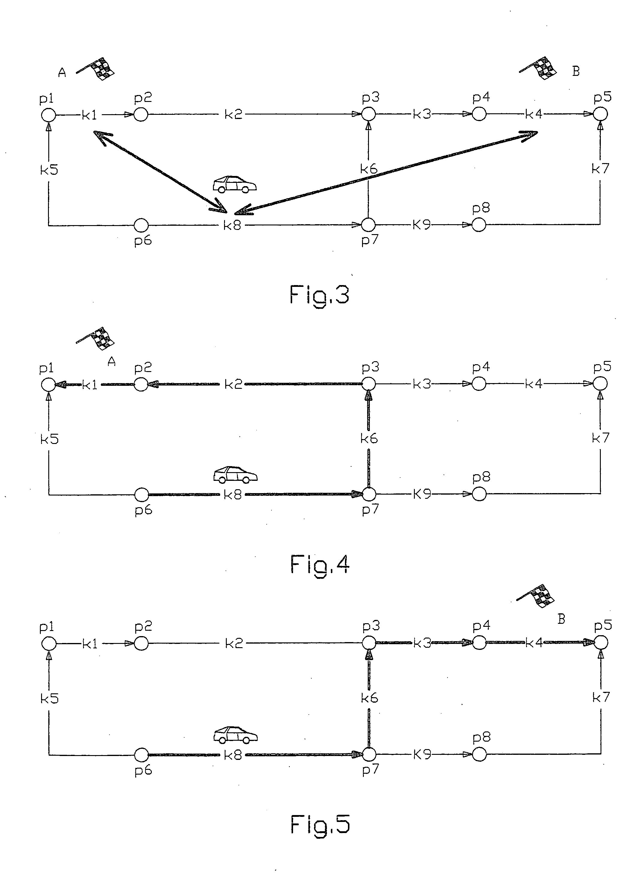
When comparing the two routes to target A and to target B, it becomes clear that the route to the nearest-lying target A does not produce the optimal route; the optimal route, in this example, is to the second-nearest target B. It is particularly a problem, in this connection, that the question as to which target produces the optimal route can be determined, using the conventional methods, only by successive calculations of the routes to all targets.

Method used


Image

  • Method for determiming boutes and rekated navigation system
  • Method for determiming boutes and rekated navigation system
  • Method for determiming boutes and rekated navigation system

Examples


Embodiment Construction

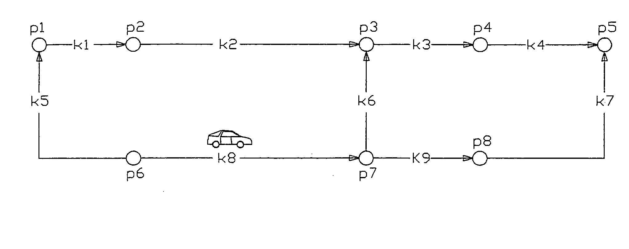
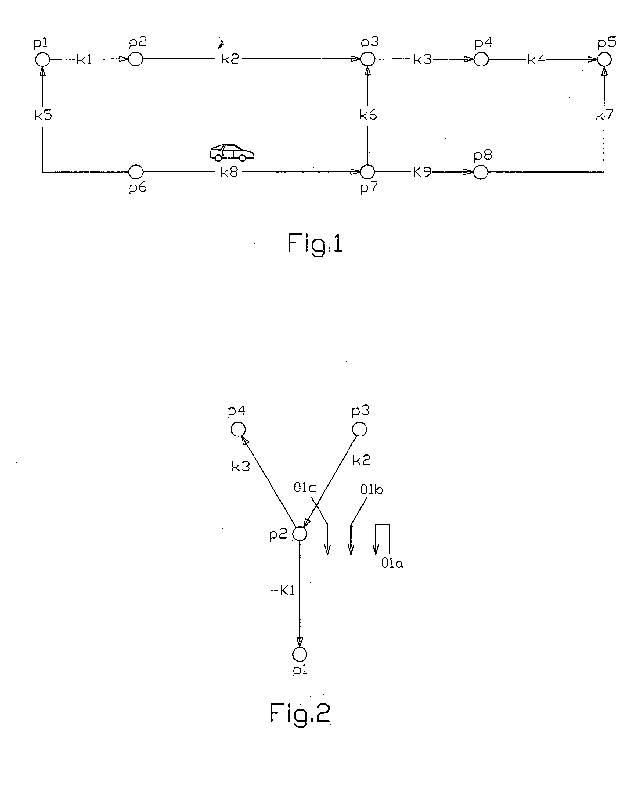
[0113] In the present exemplary embodiment of a method for ascertaining routes, the route network as shown in FIG. 1 is used to illustrate the principles of the present invention. In FIG. 1, segments k1, k3, k4, k6 and k9 each have the resistance value 10, and segments k2, k5, k7 and k8 each have the resistance value 20. At the time of consideration, the vehicle is located on segment +k8 (the “+” sign symbolizes that the travel direction corresponds to a preferred direction). The partial targets that are independent but have equal rights represent segment kg for partial target A, and represent segment k4 for partial target B.

[0114] After the definition of the two partial targets A and B (method step (R.2) in FIGS. 8 and 9), the following MultiDest Index List (see FIG. 11, top left) is derived:

MultiDest IndexStatus / Description1 / partial target A2 / partial target B

[0115] In addition, after the definition of the two partial targets A and B, the following MultiDest Description List is ...


PUM


Abstract

A method for ascertaining routes in a route network is provided, in which an optimal route to a target of a certain category can be determined. A route is calculated from a point of origin to an optimal target point from a plurality of spatially separated target points that are allocated to at least one directed segment and / or to at least one node. The method includes defining the target points from entries of addresses, map targets, target memory entries given by an index of a given category, such as, for instance, post office, gas stations. The respective route to the target point is optimized as a sequence of the directed segments having nodes situated between the directed segments such that the sum of all resistances of the sequence to the respective target point becomes a minimum. A list of the respective routes to the respective target point is then drawn up.

Description

FIELD OF THE INVENTION [0001] The present invention relates to a method for ascertaining routes in a route network, for example, a road network, that is mapped as directed segments and nodes situated between the directed segments in a memory unit. According to the method of the present invention, the route to be ascertained may be determined as a sequence or series of directed segments having nodes between the directed segments wherein a specific resistance may be allocated to each directed segment and / or each node. The present invention further relates to a navigation system related to such a method. BACKGROUND INFORMATION [0002] In currently-deployed navigation systems, the driver of a vehicle, such as a motor vehicle, can influence the route traveled in various ways, e.g., as described in published European patent document EP 0 979 987. For instance, the driver may select different optimizing criteria, such as “short route”, “fast route”, “avoid expressways” or the like, and / or c...

Claims


Application Information

Patent Timeline
IPC IPC(8): G01C21/34
CPCG01C21/3446
Inventor MUELLER, GUIDO
Owner ROBERT BOSCH GMBH
Learn More