Method and system for processing spatially-referred information such as cartographic information, applications and apparatus implementing said method

a technology of spatial data and information, applied in the field of methods for processing spatial data, can solve the problems of slow processing that is hardly admissible, large size of spatial data bases, complex systems, etc., and achieve the effect of increasing the efficiency of spatial data base processing

Inactive Publication Date: 2005-09-01
OPTEWAY
View PDF12 Cites 30 Cited by
  • Summary
  • Abstract
  • Description
  • Claims
  • Application Information

AI Technical Summary

Benefits of technology

[0030] Thus the invention consists in a systematic structuration of information wherein topologic information are separated from attribute information. Such a separation was indeed found as allowing both a simplification of the stored data and a simplification of their processing by reducing the size of information to be simultaneously processed during most of the stages.
[0058] An exact structuration of the information and an organization of the information in two distinct tables between which a correspondence mechanism is established, provide with a concision of the information that results in an increased efficiency in the spatial data base processing from the implementation of said method.

Problems solved by technology

Operating these software on a personal computer results in a processing slowness that is hardly admissible.
Furthermore, present systems are complex and difficult to use by a non-professional.
The main cause for this complexity resides in the huge size of spatial data bases which mix the three classes of precited information.
In this format, even if a difference is theoretically made between a “primitive” form and its “attributes” and “features”, information are continuously imbricate and inevitably redundant.
The Oracle-ARC / info hybrid database is used to store and manage cartographic projections and similar spatial data in conjunction with attributes relates to the spatial data, but does not analyze and organize said spatial data.
A primary drawback of the hybrid approach as taught in cited documents is the requirement of maintaining two discrete database engines, and a proprietary data structure using unique spatial indexes.
Moreover, this hybrid approach results paradoxically in a substantial increase in the size and the complexity of the index.
Another disadvantage of these hybrid systems is that it has lead to the development of “exchange standards” defining standard data format enabling reading data created in one system by another.
More generally, existing systems require too complex computer processing and important data storage means, whatever their format.
Miniaturizing these systems in view of integrating for example into an electronic apparatus is hardly conceivable.

Method used


Image

  • Method and system for processing spatially-referred information such as cartographic information, applications and apparatus implementing said method
  • Method and system for processing spatially-referred information such as cartographic information, applications and apparatus implementing said method
  • Method and system for processing spatially-referred information such as cartographic information, applications and apparatus implementing said method

Examples


Embodiment Construction

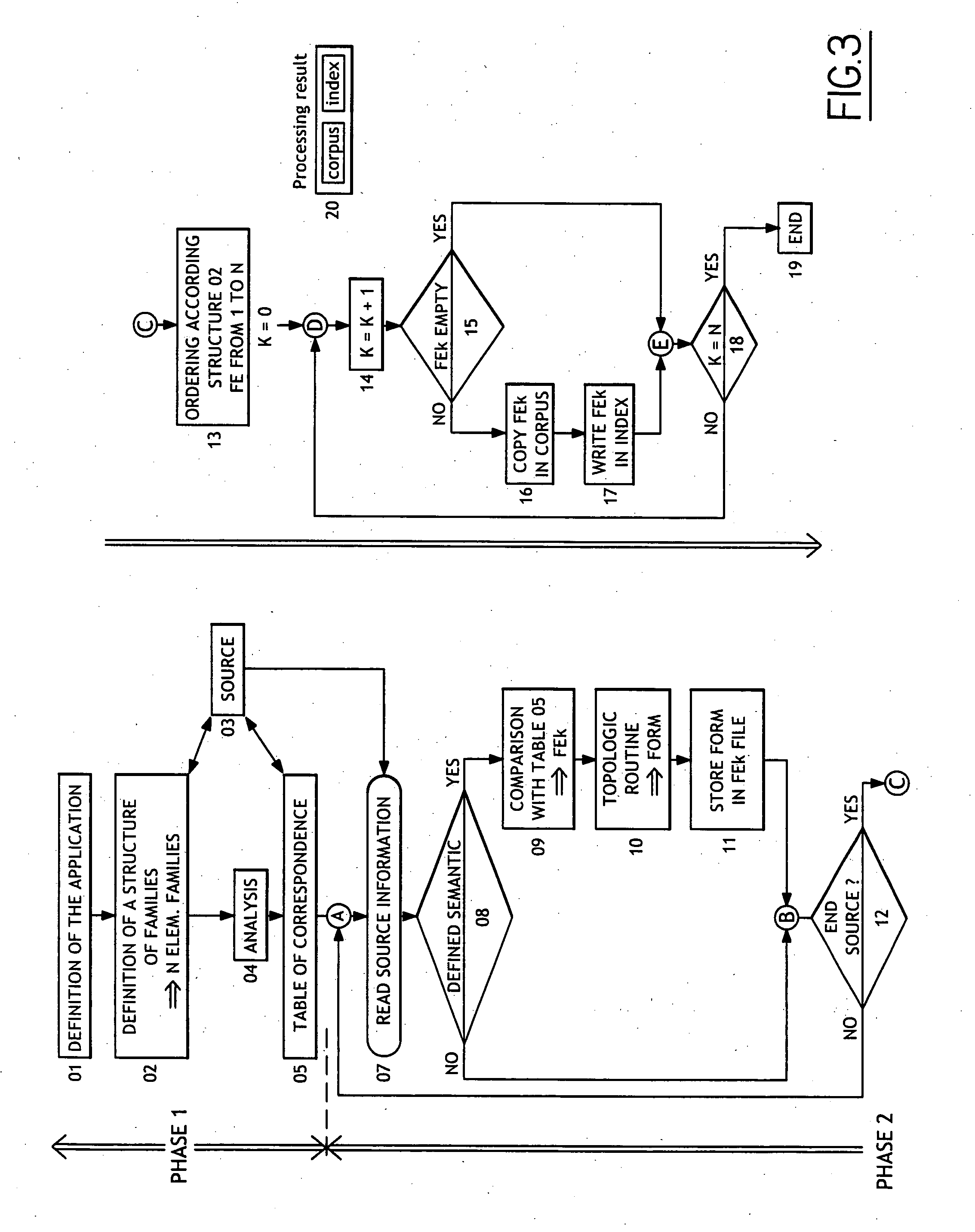
[0080] First, the main principles on which the method according to the invention is based, are presented, with practical examples of implementation.

[0081] Two types of information are considered: [0082] topologic information: [0083] the geometric form [0084] the position [0085] attributes: [0086] formal (or aspect) [0087] semantic (or functional) [0088] of graphic representation (display)

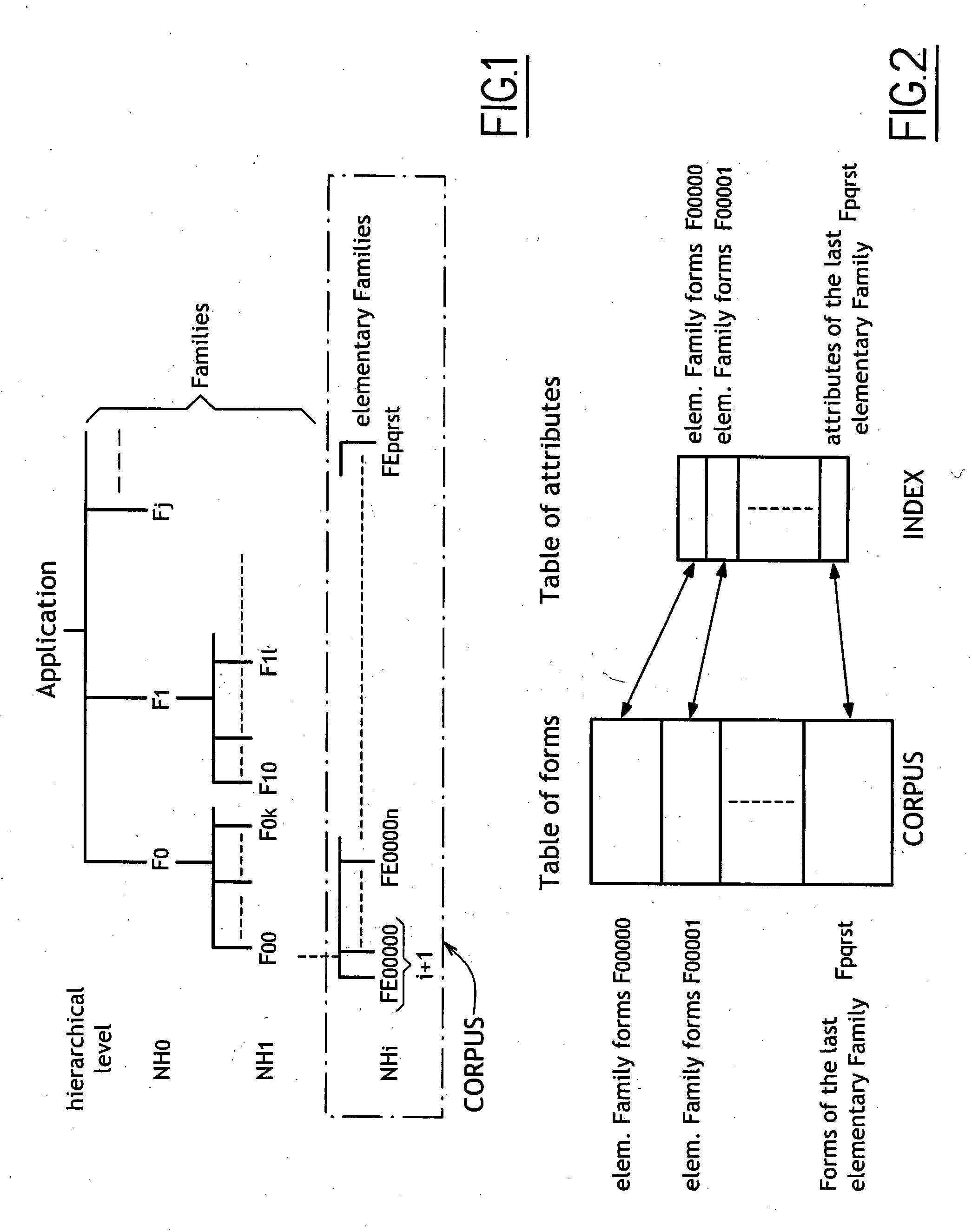
[0089] The hierarchic gathering of objects for a given application leads to an arborescent organization, as illustrated by FIG. 1, that uses the three following notions: [0090] 1. hierarchic level NH [0091] 2. generic family F, without any precision on the level, and [0092] 3. elementary family FE, which is the family with the lowest hierarchic level.

[0093] In most of the applications, the objects are defined by several geometric forms. For reasons of efficiency and flexibility, it is recommended to gather into distinct elementary families the simple forms (line, arc, ellipses), the complex famil...


PUM


Abstract

A system for processing spatially-referred information (spatial data), the information defines objects in a n-dimensions space and includes for each object information of form, information of position and information of attributes. The system includes structuring the spatially-referred information, by separating the topological information from the information of attributes, cutting each topologic information into geometric information constituting information of form and information of position, ordering descriptions of the objects into elementary families having the same attributes, by applying criteria formed into a hierarchy, and organizing structured information into two distinct tables comprising a block of information. The tables include a topologic table, referred to as the corpus, containing, for each elementary family, all the geometric forms defining objects with similar attributes, and a table of attributes, referred to as the index, containing the semantic and formal attributes, associated with the objects.

Description

FIELD OF THE INVENTION [0001] The present invention relates to a method for processing spatially-referred information, i.e. linked to a n-dimensions coordinates system. For example, this processing method can be applied to cartographic information linked to a three-dimensions (x, y, z) euclidian system o-r biologic information linked to a four-dimensions (x, y, z, t) system. BACKGROUND OF THE INVENTION [0002] As a way of non-limitative example, geographic implementations are contemplated, and more particularly geographic information systems (GIS). This expression is indifferently used for three distinct, though linked, entities: [0003] (a) a data base that includes both geometric shapes of a spatial entity (e.g. a chain of coordinates representing a shape of a lake) and thematic attributes (e.g. for a lake, the maximum depth, the volume, the elevation of a surface, the salinity and the pH), [0004] (b) a software (such as ESRI by ARC / INFO, or MGE by Intergraph) used for managing, ana...

Claims


Application Information

Patent Timeline
Patent Type & Authority Applications(United States)
IPC IPC(8): G06F17/30G06F12/00G06T17/05
CPCG06F17/30241G06F16/29
Inventor POPOVICI, LASCAR
Owner OPTEWAY
Why Eureka
Try Eureka