System and method of geospatially mapping topological regions and displaying their attributes

a topological region and topological map technology, applied in the field of digital, streetcenterline based, geographic information systems, can solve the problems of inability to display exact, accurate physical locations, and address range interpolation data models that are not capable of meeting the need for exact address locations

Inactive Publication Date: 2005-09-22
GIS DATA RESOURCES
View PDF7 Cites 107 Cited by
  • Summary
  • Abstract
  • Description
  • Claims
  • Application Information

AI Technical Summary

Benefits of technology

[0016] (e) displaying a geospatial map of the geographical region and point features with one or more of the attached attributes within a GIS or CAD system.

Problems solved by technology

In the case of fire response, time can also make the difference between life and death, and it can take a large fire engine a several minutes to change course or perform a U-turn, adding urgency to the responder setting out with accurate information.
Prior art GIS street databases are not capable of displaying exact, accurate physical locations of street addresses, thus, in mission-critical applications, these address range interpolation data models are not capable of meeting the need for an exact address location.

Method used


Image

  • System and method of geospatially mapping topological regions and displaying their attributes
  • System and method of geospatially mapping topological regions and displaying their attributes
  • System and method of geospatially mapping topological regions and displaying their attributes

Examples


example

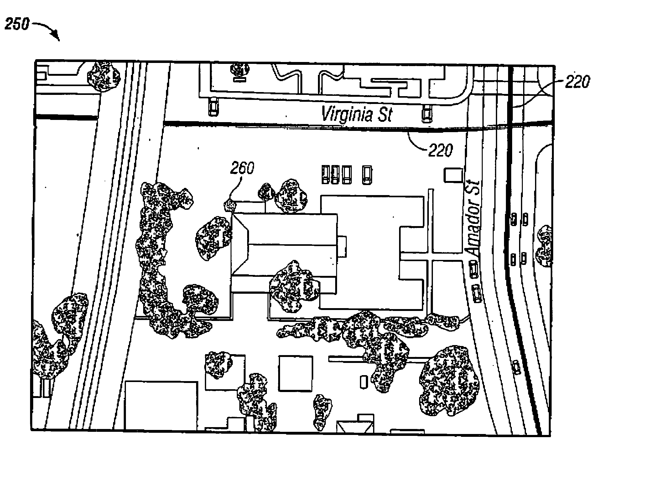
[0143] A specific product created using the method of the present invention was created for the City of Vallejo, Calif., Police Department, detailing the city of Vallejo, Calif. (the Vallejo Product). This example refers to a single public building, the Vallejo Community Center, located at 225 Amador St., Vallejo, Calif. 94590. One skilled in the art will recognize that exactly the same specific process steps were simultaneously performed for every other structure / address within the city of Vallejo for this product.

[0144] The Vallejo Product began with surveyed parcel polygon data. FIG. 5 shows the surveyed parcel polygon 200 for the Vallejo Community Center. This data was entered into a computer by digitally scanning paper records of parcel data. Additionally, FIG, 5 shows the unique Assessor Parcel Number 202 (APN) or Parcel Identifier Number (PIN) associated with the parcel on which the Vallejo Community Center is located.

[0145] The computer system used for the Vallejo Project ...


PUM


Abstract

A geographical information system and a method are disclosed for geospatially mapping a least one parcel polygon within a geographical region and for displaying at least one specific attribute of each parcel polygon, i.e. a topological area within the given geographical region, as an attached attribute of latitude and longitude coordinates. The centroid or center point of each of the parcel polygons is determined and stored into conventional computer storage means. The latitude and longitude point feature at the centroid of each parcel polygon is established and similarly stored. A unique tax identification number, e.g. the Assessor Parcel Number (APN) or Parcel Identifier Number (PIN), is assigned to each of the point features. A correlation is then made between the unique tax identification number of the point feature to a text list of at least one attribute, e.g., the physical address of the parcel polygon, of each of the point features. This attribute becomes attached to each point feature. The resulting parcel polygon map and point features with one or more of the attached attributes can then be displayed within a GIS or CAD system to provide the user, for example, accurate locations of street addresses for use in environments that require pinpoint accuracy, such as emergency response.

Description

[0001] This application claims the benefit of prior U.S. provisional application Ser. No. 60 / 357,571, filed Feb. 15, 2002.FIELD OF INVENTION [0002] The present invention relates generally to digital, street-centerline based, geographic information systems (GIS). More particularly it relates to a geographical information system capable of locating and displaying a physical address or array of addresses in exact geographical location, and a method of linking and making available specific latitude and longitude coordinates as well as other attributes for each address or property. BACKGROUND OF THE INVENTION [0003] The prior art encompasses the long human history of cartography and navigation up to and including recent technological innovations. Examples include the achievement of seaworthy timepieces, which revolutionized and made accessible exact and reliable readings of longitude, and satellite technology and the Global Positioning System (GPS), which have revolutionized navigation. ...

Claims


Application Information

Patent Timeline
Patent Type & Authority Applications(United States)
IPC IPC(8): G06T17/05
CPCG06T17/05
Inventor ANDERSON, JAMES J.
Owner GIS DATA RESOURCES
Why Eureka
Try Eureka