Volumetric sensor for mobile robotics

a mobile robot and sensor technology, applied in the field of multi-sensor system for 3d mobile robot navigation, localization and mapping, can solve the problems of limited scene view, high cost, limited peripheral vision of mobile robots,

Inactive Publication Date: 2005-11-03
HER MAJESTY THE QUEEN AS REPRESENTED BY THE MINIST OF NAT DEFENCE OF HER MAJESTYS CANADIAN GOVERNMENT
View PDF6 Cites 61 Cited by
  • Summary
  • Abstract
  • Description
  • Claims
  • Application Information

AI Technical Summary

Benefits of technology

[0006] A volumetric sensor for mobile robot navigation to avoid obstacles in the robot's path comprises a laser volumetric sensor mounted on a platform with a laser and detector directed to a tiltable mirror in the transparent cy

Problems solved by technology

Currently, mobile robots are lacking in good peripheral vision to detect and track obstacles or plan paths in crowded or complex environments.
Some lidars could be found on the market, but if they provide mapping in

Method used


Image

  • Volumetric sensor for mobile robotics
  • Volumetric sensor for mobile robotics
  • Volumetric sensor for mobile robotics

Examples


Embodiment Construction

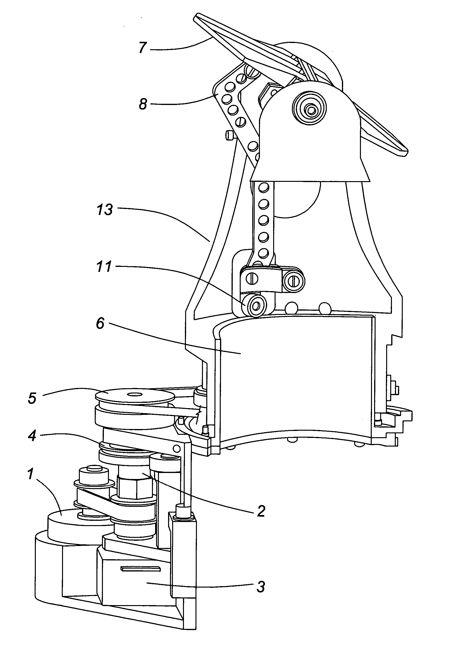
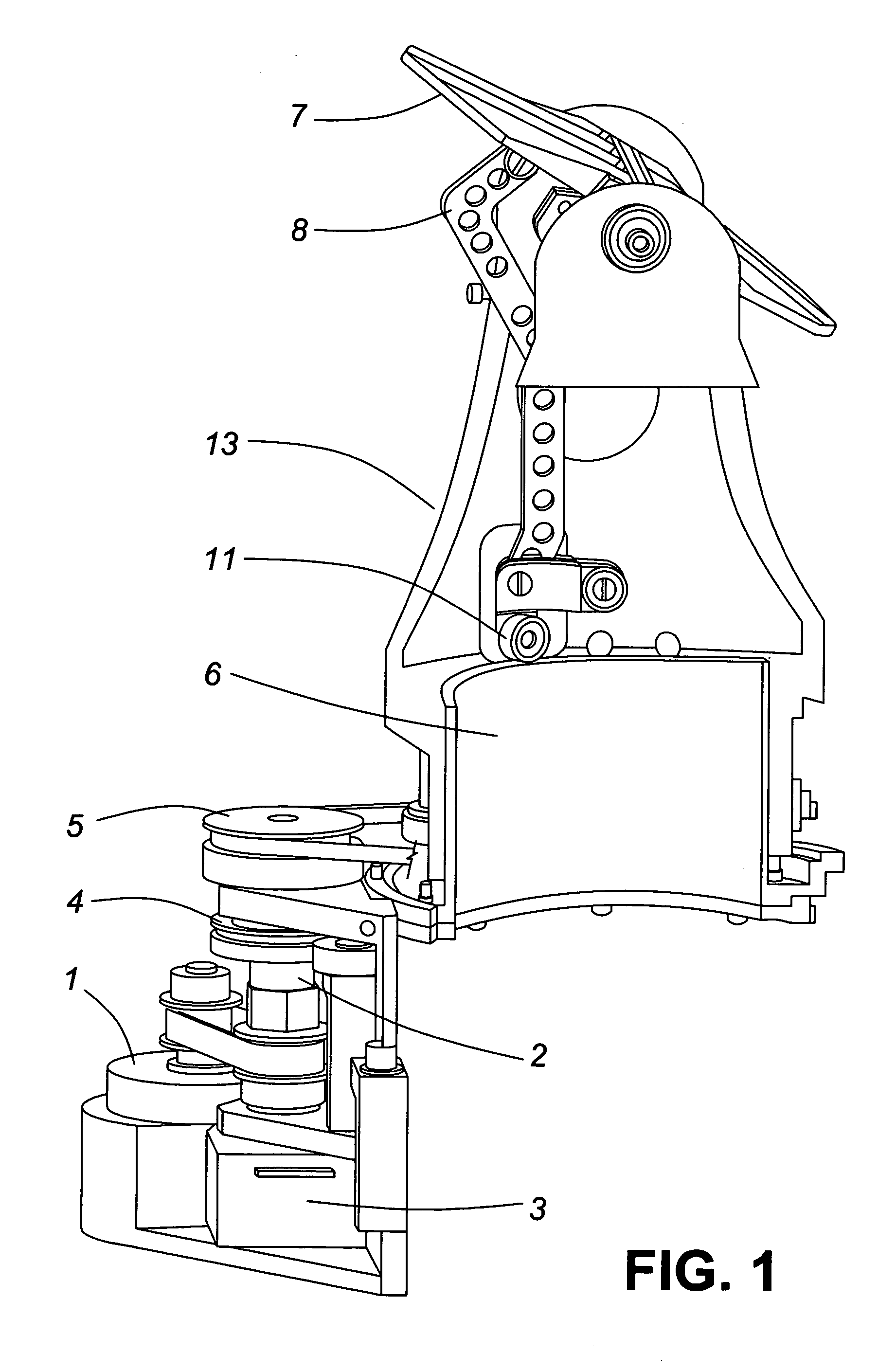
[0010] Currently, mobile robots are lacking in good peripheral vision to detect and track obstacles or plan paths in crowded or complex environments. One of the best ways to accurately sense the environment around the robot is by using laser ranging (lidar). Some lidars could be found on the market, but if they provide mapping in 3D, they are big, use lots of power and are expensive. Smaller ones provide only line scans on limited angular range (max 180° around the platform) resulting in limited view of the scene. Mobile robots moving in complex terrains need to track landmarks and obstacle all around the platform for navigation purpose.

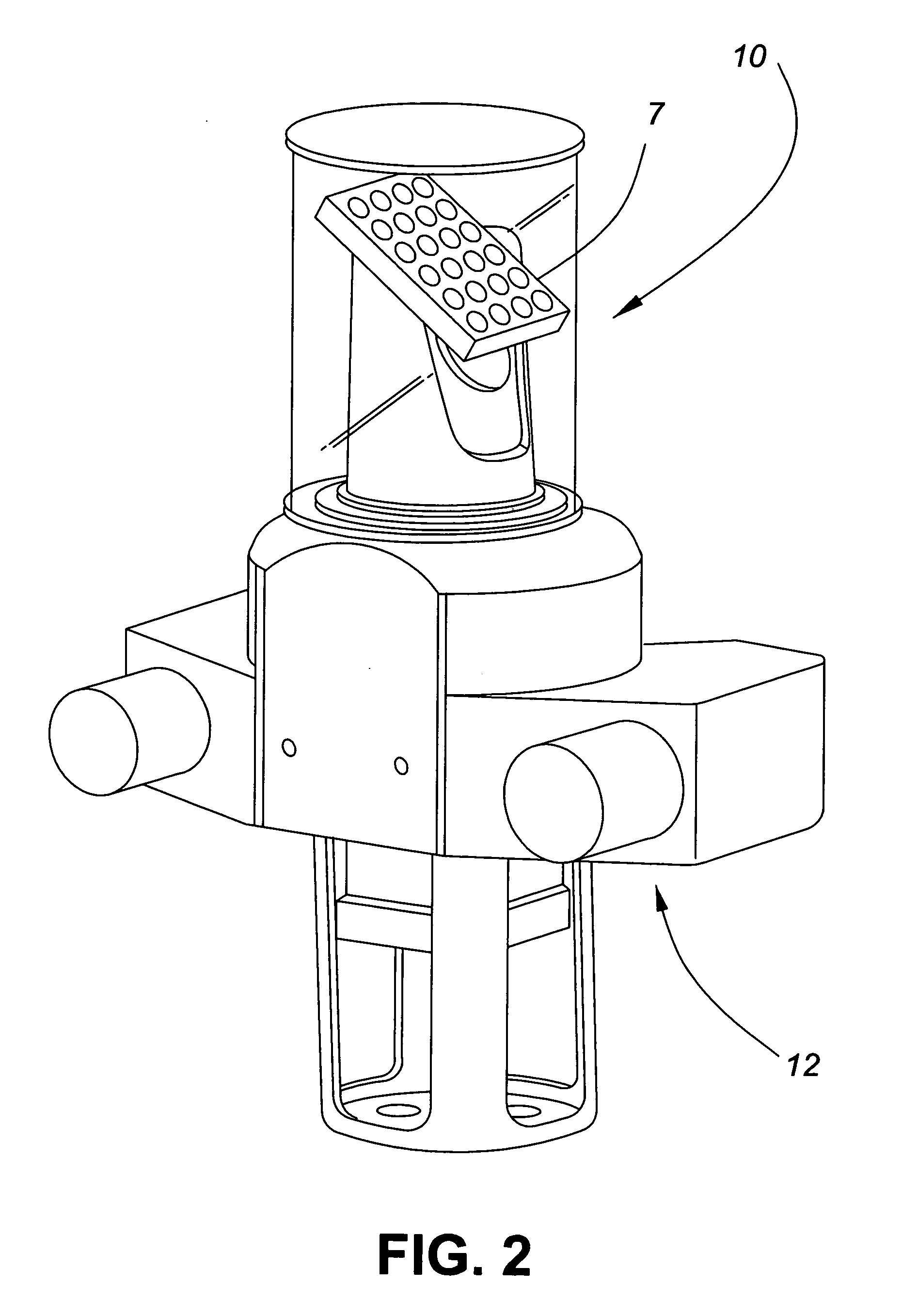
[0011] Lars S. Nyland (IEEE Proceedings, 1998) in an article entitled Captured Dense Environmental Range Information with a Panning Scanning Laser Range Finder describes a laser range finder that uses a rotating mirror tilted at 45° that allows for range measurement in a 300° sweep and includes a digital camera where, after an environment is scanned...


PUM


Abstract

A volumetric sensor for mobile robot navigation to avoid obstacles in the robot's path includes a laser volumetric sensor on a platform with a laser and detector directed to a tiltable mirror in a cylinder that is rotatable through 360° by a motor, a rotatable cam in the cylinder tilts the mirror to provide a laser scan and distance measurements of obstacles near the robot. A stereo camera is held by the platform, that camera being rotatable by a motor to provide distance measurements to more remote objects.

Description

[0001] This claims benefit of Provisional Application Ser. No. 60 / 566,941 filed on 3 May 2004.FIELD OF THE INVENTION [0002] The present invention relates to a multi sensor system for 3D mobile robot navigation, localization and mapping that combine a high-repetition rate laser range sensor and a stereo camera. BACKGROUND OF THE INVENTION [0003] Currently, mobile robots are lacking in good peripheral vision to detect and track obstacles or plan paths in crowded or complex environments. One of the best ways to accurately sense the environment around the robot is by using laser ranging (lidar). Some lidars could be found on the market, but if they provide mapping in 3D, they are big, use lots of power and are expensive. Smaller ones provide only line scans on limited angular range (max 180° around the platform) resulting in limited view of the scene. Mobile robots moving in complex terrains need to track landmarks and obstacle all around the platform for navigation purpose. [0004] Lars...

Claims


Application Information

Patent Timeline
IPC IPC(8): B25J19/04G01S7/481G01S11/12G01S17/42G01S17/86G01S17/931G06F19/00
CPCG01S7/4812G01S7/4813G01S7/4817G01S17/936G01S17/023G01S17/42G01S11/12G01S17/86G01S17/931
Inventor RICARD, BENOIT
Owner HER MAJESTY THE QUEEN AS REPRESENTED BY THE MINIST OF NAT DEFENCE OF HER MAJESTYS CANADIAN GOVERNMENT
Why Eureka
Try Eureka