Communication system and method for comprehensive collection, aggregation and dissemination of geospatial information

a technology of communication system and geospatial information, applied in the field of spatial modeling, can solve the problems of ineffective allocation of resources for data collection, duplication, if not conflicting, of data collection and reporting, and the effort to obtain and organize geospatial information has suffered, so as to ensure the accuracy of data collection

Inactive Publication Date: 2005-11-17
SPADAC
View PDF9 Cites 25 Cited by
  • Summary
  • Abstract
  • Description
  • Claims
  • Application Information

AI Technical Summary

Problems solved by technology

Past efforts at obtaining and organizing geospatial information have suffered from inefficient allocation of resources for data collection, improper coordination and evaluation of the collected information and duplicative, if not conflicting, data collection and reporting.

Method used


Image

  • Communication system and method for comprehensive collection, aggregation and dissemination of geospatial information
  • Communication system and method for comprehensive collection, aggregation and dissemination of geospatial information
  • Communication system and method for comprehensive collection, aggregation and dissemination of geospatial information

Examples


Embodiment Construction

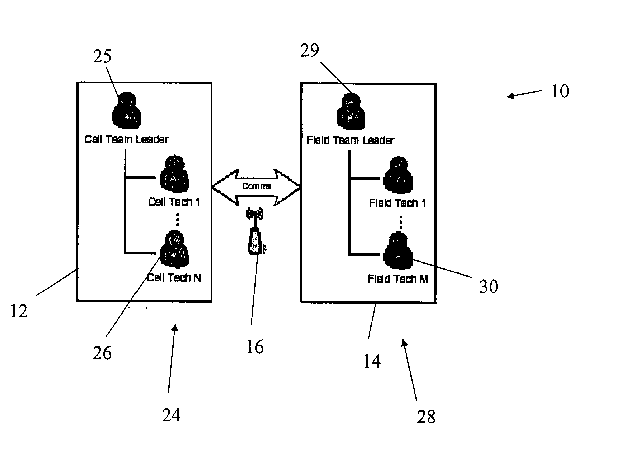
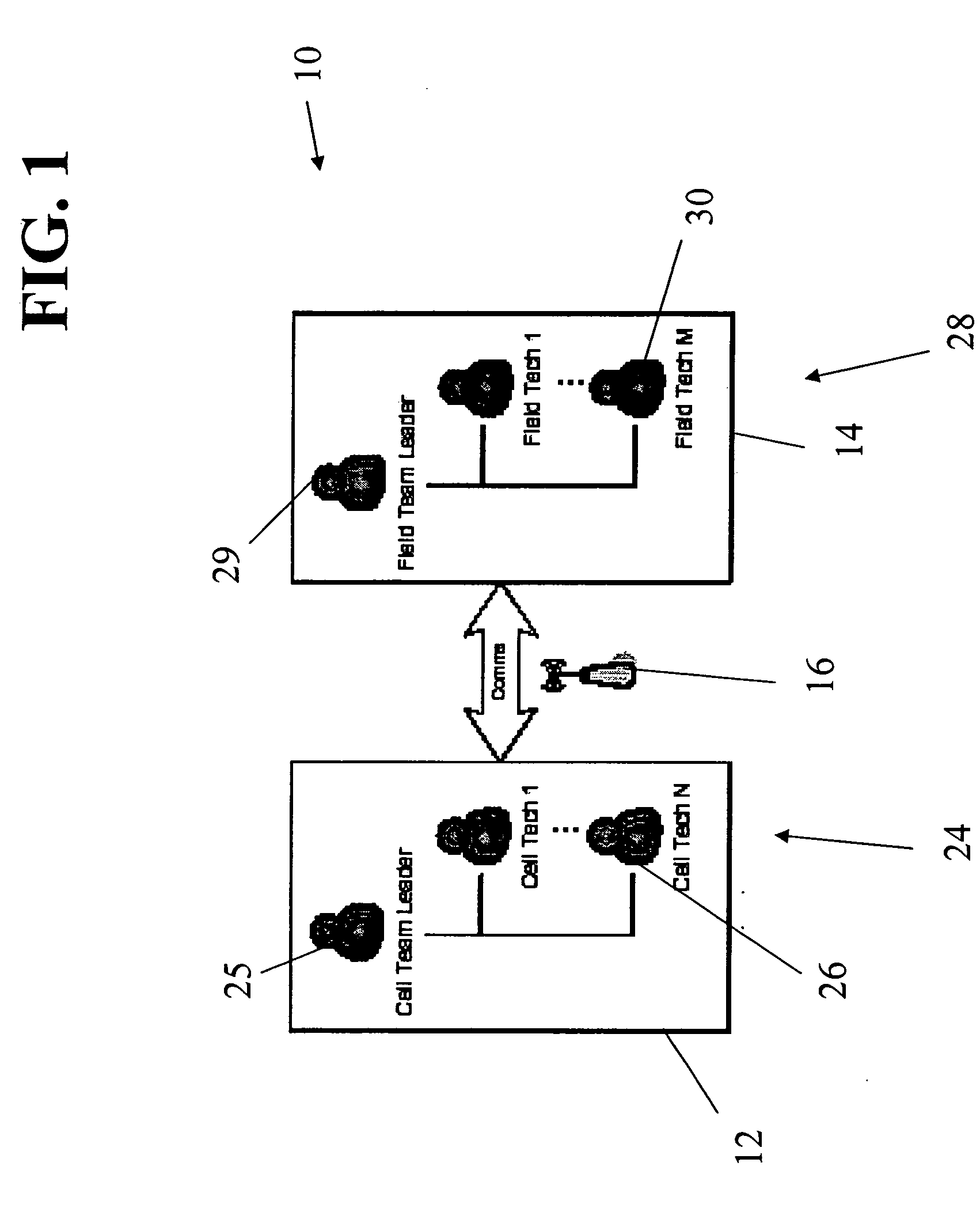
[0016]FIG. 1 is a schematic diagram showing the hierarchical arrangement and overall structure of one embodiment of the system 10 of the present invention. The system 10 as shown therein includes a remote command component 12, a field component 14, and a communications component 16 for providing two-way communication between the remote command component 12 and the field component 14. Communications component 16 can operate using known technologies to facilitate communication between cell-remote members and cell-local members, even in highly remote areas. Such communications can involve, for example, satellite uplinks from the cell-local member(s) sending signals to satellites for propagation and delivery to cell-remote members, cellular communications, wireline communications, and other known communication formats.

[0017] Remote command component 12 can be operated by a cell team 24, which can be a research, communications and / or business unit designed to efficiently collect and man...


PUM


Abstract

A communication system and method coordinates data collection resources, both in the field and remotely, in real-time so as to rapidly collect, organize and manage frequently changing geospatial information on a cellular level. The present invention further provides a system and method for ensuring the accuracy of data collection, including a rewards system which can reward formal and informal / ad hoc “field” agents for providing information pertaining to particular cells within an area of interest.

Description

REFERENCE TO RELATED APPLICATIONS [0001] This application claims the benefit of U.S. provisional patent application Ser. No. 60 / 571,771, filed May 17, 2004 and entitled “System and Method for Organizing the Collection, Aggregation and Dissemination of Geospatial Information”, the disclosure of which is incorporated herein by reference.FIELD OF THE INVENTION [0002] The present invention relates to spatial modeling, and more particularly provides a communications system and method for comprehensive collection, aggregation and dissemination of geospatial information for a variety of purposes. BACKGROUND OF THE INVENTION [0003] Geospatial modeling offers an approach to solutions to a variety of corporate, governmental and individual problems. The effectiveness of a geospatial model is largely dependent upon the accuracy, detail and integrity of the data supporting the model. Past efforts at obtaining and organizing geospatial information have suffered from inefficient allocation of reso...

Claims


Application Information

Patent Timeline
Patent Type & Authority Applications(United States)
IPC IPC(8): G06F17/30H04B7/14H04J1/10H04J3/08H04Q7/20
CPCG06F17/3087G06F16/9537H04L67/025H04L67/12
Inventor DUMAS, MARK E.STOKES, JAMES
Owner SPADAC
Why Eureka
Try Eureka