
System and method for processing and displaying traffic information in an automotive navigation system

a technology of navigation system and traffic information, applied in the field of automotive navigation system, can solve the problems of insufficient information provided to the driver of the vehicle by flow indicators, navigation systems with traffic indication capability all failing to take into account traffic flow conditions which vary, and previously known navigation systems that have traffic indication capability failing to accommodate different driving habits

Inactive Publication Date: 2006-03-16
CLARION CO LTD
View PDF26 Cites 275 Cited by
  • Summary
  • Abstract
  • Description
  • Claims
  • Application Information

AI Technical Summary

Benefits of technology

The present invention is a navigation system with a traffic flow display that overcomes the shortcomings of previous devices. The system stores speed threshold limits for different traffic flow categories, and receives data on traffic flow conditions on road segments. The received data is then compared with the speed threshold limits to determine the traffic flow category for each road segment, and a visual indicator is displayed on the screen to correspond to the traffic flow category. The system also preprocesses the traffic flow data to eliminate redundant and obvious errors, and displays other data pertaining to traffic congestion. The driver is provided with a visual indication of whether the displayed information is current or not, and an indication when the data is currently being updated. Overall, the invention improves the user experience by providing more accurate and useful information on traffic flow conditions.

Problems solved by technology

These previously known navigation systems having traffic flow display capabilities, however, all suffer from a number of common disadvantages.
One disadvantage is that these previously known navigation systems fail to accommodate different drivers with different driving habits.
Similarly, these previously known navigation systems with traffic indication capability all fail to take into account traffic flow conditions which vary as a function of other driving conditions.
Because of this, the previously known navigation systems with traffic flow indicators have provided inadequate information to the driver of the vehicle for the driver of the vehicle to determine the actual traffic flow conditions for one or more road segments.
A still further disadvantage of these previously known navigation systems with traffic flow indication capability is that such systems are limited strictly to a display of the relative traffic congestion along the various road segments displayed on the display device.
These systems, however, are unable to display other data to the driver in order to enable the driver to assess the actual road conditions.
These previously known systems, however, do not display such information.

Method used


Image

  • System and method for processing and displaying traffic information in an automotive navigation system
  • System and method for processing and displaying traffic information in an automotive navigation system
  • System and method for processing and displaying traffic information in an automotive navigation system

Examples


Embodiment Construction

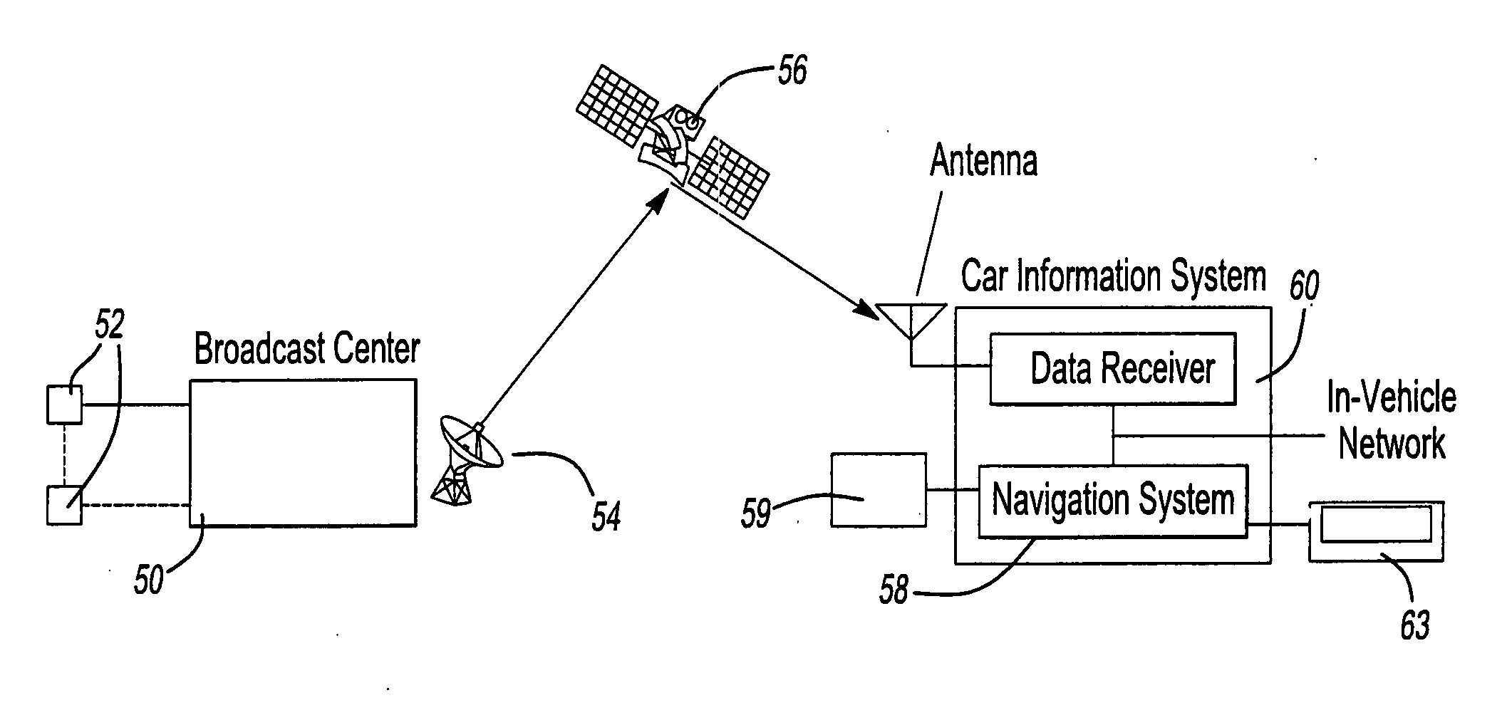
[0046] With reference first to FIG. 1, the method of the present invention is for use with a traffic information collection system having a central station 50 which collects data across a geographical area, such as the United States, from a plurality of traffic flow sensors 52. Other data collecting devices and sources can include traffic cameras, traffic information collected by police or highway departments, website sentry collected information, speed sensors located in cars and transmitted to a central server, speed calculations made from car position information, as well as any other source indicative of traffic flow conditions. The central station 50 then collates the inputted data from the sensors 52 and transmits via a transmitting antenna 54 the collated data to a satellite 56. This satellite 56 then transmits the collated data back to the earth where it is received by a data receiver 60 for a navigation system 58 having a display screen 63 and memory 59. For example, the sa...


PUM


Abstract

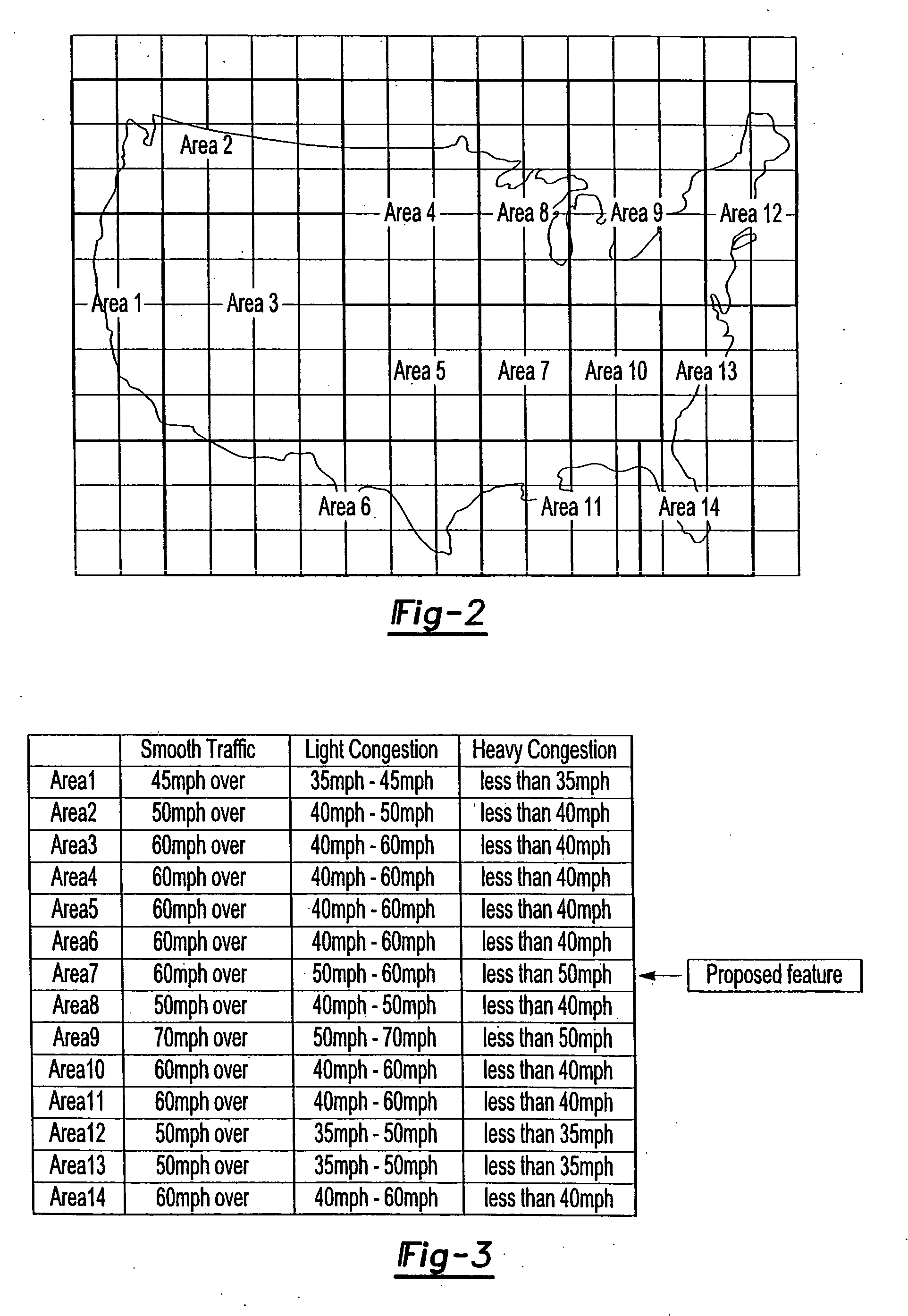
A system and method for displaying traffic information in an automotive navigation system having a display, memory and a data receiver. The method includes the first step of storing in a traffic speed table in memory at least two speed threshold limits wherein each speed threshold limit represents a different traffic flow category. The receiver receives data representative of the vehicle speed on at least one road segment and compares that received vehicle speed data with the traffic speed table to determine the traffic flow category corresponding to the received speed data for the road segment. A visual indicator is then displayed on the display which corresponds to the traffic flow category for the road segment. The user is able to customize the speed threshold limits through a GUI. These speed threshold limits are further user modifiable as a function of weather, day of the week, road conditions, type of road, as well as other factors.

Description

BACKGROUND OF THE INVENTION [0001] I. Field of the Invention [0002] The present invention relates generally to automotive navigation systems and, more particularly, to a method for displaying traffic information in an automotive navigation system. [0003] II. Description of Related Art [0004] Automotive navigation systems have become increasingly prevalent in automotive vehicles. Such navigation systems typically include a display screen mounted in the vehicle in a position visible to the driver. Conventionally, such automotive navigation systems display a road map on the screen and, by using GPS to determine the position of the vehicle, also display the position of the vehicle on the screen. [0005] Many roads, and certainly most major roads, include traffic sensors which detect the average vehicle speed at the position of the sensor on its given road as well as traffic events which potentially affect traffic flow. These traffic sensors transmit this traffic flow data to a central st...

Claims


Application Information

Patent Timeline
Patent Type & Authority Applications(United States)
IPC IPC(8): G08G1/123G08G1/09G08G1/00
CPCG08G1/0962B60R11/04
Inventor KAWAMATA, YUKIHIRORAMASWAMY, DEEPAKKURAMI, KUNIHIKO
Owner CLARION CO LTD
Learn More