Method of operating a navigation system to report effects of updated portions of a geographic database

a technology of geographic database and navigation system, applied in traffic control systems, navigation instruments, instruments, etc., can solve the problems of reducing the usefulness of the system, burdening and time-consuming, and out-of-date geographic data used in computer-based navigation systems

Active Publication Date: 2006-04-06
HERE GLOBAL BV
View PDF31 Cites 150 Cited by
  • Summary
  • Abstract
  • Description
  • Claims
  • Application Information

AI Technical Summary

Problems solved by technology

Just like conventional printed maps, geographic data used in computer-based navigation systems can become out-of-date.
This can be burdensome and time consuming because of the large amount of data involved, much of which is identical to the data in the user's previous version of the geographic database.
Thus, a user's geographic database has the potential for being out-of-date thereby decreasing its usefulness.
One downside of updating a portion of the geographic data is the effects of the partially updated geographic data may have on the navigation-related functions and features.

Method used


Image

  • Method of operating a navigation system to report effects of updated portions of a geographic database
  • Method of operating a navigation system to report effects of updated portions of a geographic database
  • Method of operating a navigation system to report effects of updated portions of a geographic database

Examples


example 1

A. EXAMPLE 1

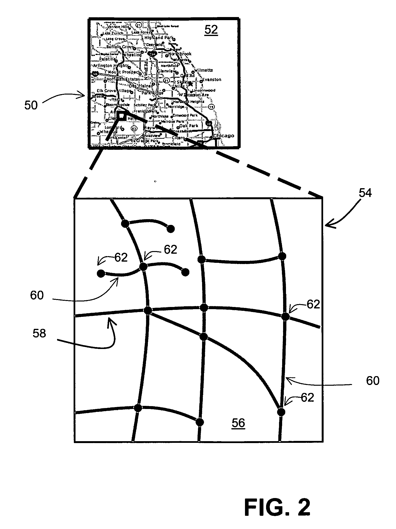
[0068] Example 1 illustrates a case where features, such as road segments and / or nodes, have been added or removed across a boundary between an updated region and un-updated region. FIG. 10a illustrates a map 150 of a geographic region 152 represented in the master geographic database 112 on Jul. 1, 2003. The geographic region 152 includes an Illinois portion 154 and an Indiana portion 156. The region 152 includes a road 158 that runs from the Indiana portion 156 into the Illinois portion 154 and then curves back into the Indiana portion 156. FIG. 10b illustrates a map 160 of the geographic region 152 represented in the master geographic database 112 on Jul. 1, 2004. Between Jul. 1, 2003 and Jul. 1, 2004, a new road 162 called Aldine Street has been constructed, a road 164 called Wells Street was torn down, and the master geographic database 112 has been modify to represent the new features of the geographic region 152.

[0069] In the present example, an end user has a na...

example 2

B. EXAMPLE 2

[0072] Example 2 illustrates a case where shape point(s) that cross a boundary between an updated region and an un-updated region have been repositioned; shape points represent the shape and position of features, such as road segments, rivers, lakes, and so on. FIG. 12 illustrates a map 180 of a geographic region 182 represented in the master geographic database 112 on Jul. 1, 2003. The geographic region 182 includes an Illinois portion 184 and an Indiana portion 186. The region 182 includes roads 188, 190, 192 and 194 that run from the Illinois portion 184 into the Indiana portion 186. FIG. 12 also illustrates a map 196 of the geographic region 182 represented in the master geographic database 112 on Jul. 1, 2004. During the year, the geographic database provider has repositioned the roads 188, 190, 192 and 194 to more accurately represent their actual physical location.

[0073] In the present example, an end user has a navigation system 10 as illustrated in FIG. 1. The ...

example 3

C. EXAMPLE 3

[0078] Example 3 illustrates a case where features, such as road segments, are added or removed in the higher layers of the geographic data of the geographic database. In one embodiment of the geographic database 26, higher level roads, such as interstate highways, are stored in multiple parcels in order to limit the amount of data that is needed to be read from the storage medium when the map display application 38 performs a zoom out operation. The higher layer parcels are less populated than the lower layer parcels and cover a larger area. FIG. 14a illustrates a map 200 of a geographic region of the continental United States represented in the master geographic database 112 on Jul. 1, 2003. The continental United States is organized into parcels at three levels: layer 1, layer 2 and layer 3. Layer 1 includes parcels 202 containing only data related to interstate highways; layer 2 includes parcels 204 containing data related to interstate highways and intrastate roads;...


PUM


Abstract

A method for operating a navigation system that executes a navigation application software program to provide a navigation-related feature is provided. The method comprises identifying that the navigation application software program uses both updated geographic data and un-updated geographic data from a geographic database associated with said navigation system. The un-updated geographic data has an associated date or version different from the updated geographic data. The method further comprises providing a report indicating that an inconsistency between the updated geographic data and the un-updated geographic data may exist. The method may further include identifying the inconsistency between the updated geographic data and the un-updated geographic data.

Description

BACKGROUND OF THE INVENTION [0001] The present invention relates to a method and system for operating a navigation system, and more particularly to a method and system for operating a navigation system to report the effects of updated portions of a geographic database. [0002] Navigation systems are available that provide end users with various navigation-related functions and features. For example, some navigation systems are able to determine an optimum route to travel along a road network from an origin location to a destination location in a geographic region. Using input from the end user, and optionally from equipment that can determine the end user's location (such as a GPS system), the navigation system can examine various potential routes between the origin and destination locations to determine the optimum route. The navigation system may then provide the end user with information about the optimum route in the form of guidance that identifies the driving maneuvers required...

Claims


Application Information

Patent Timeline
Patent Type & Authority Applications(United States)
IPC IPC(8): G01C21/36
CPCG01C21/32G06F17/30241G06F16/29G01C21/3859G01C21/3878Y10S707/99954Y10S707/99953
Inventor KAUFMAN, MICHAEL L.HECHT, CHRISTIAN ANDREAS
Owner HERE GLOBAL BV
Why Eureka
Try Eureka