Eureka AIR delivers breakthrough ideas for toughest innovation challenges, trusted by R&D personnel around the world.

Global visualization process for personal computer platforms (GVP+)

a technology of personal computers and visualization processes, applied in the field of optimal visualization of complex scenarios, can solve the problems of unacceptably low update rate and small data input range, and achieve the effects of accurate and rapid visualization of an area, high resolution, and convenient us

Inactive Publication Date: 2006-07-06
US SEC THE NAVY CHIEF OF NAVAL RES OFFICE OF COUNSEL
View PDF15 Cites 31 Cited by
  • Summary
  • Abstract
  • Description
  • Claims
  • Application Information

AI Technical Summary

Benefits of technology

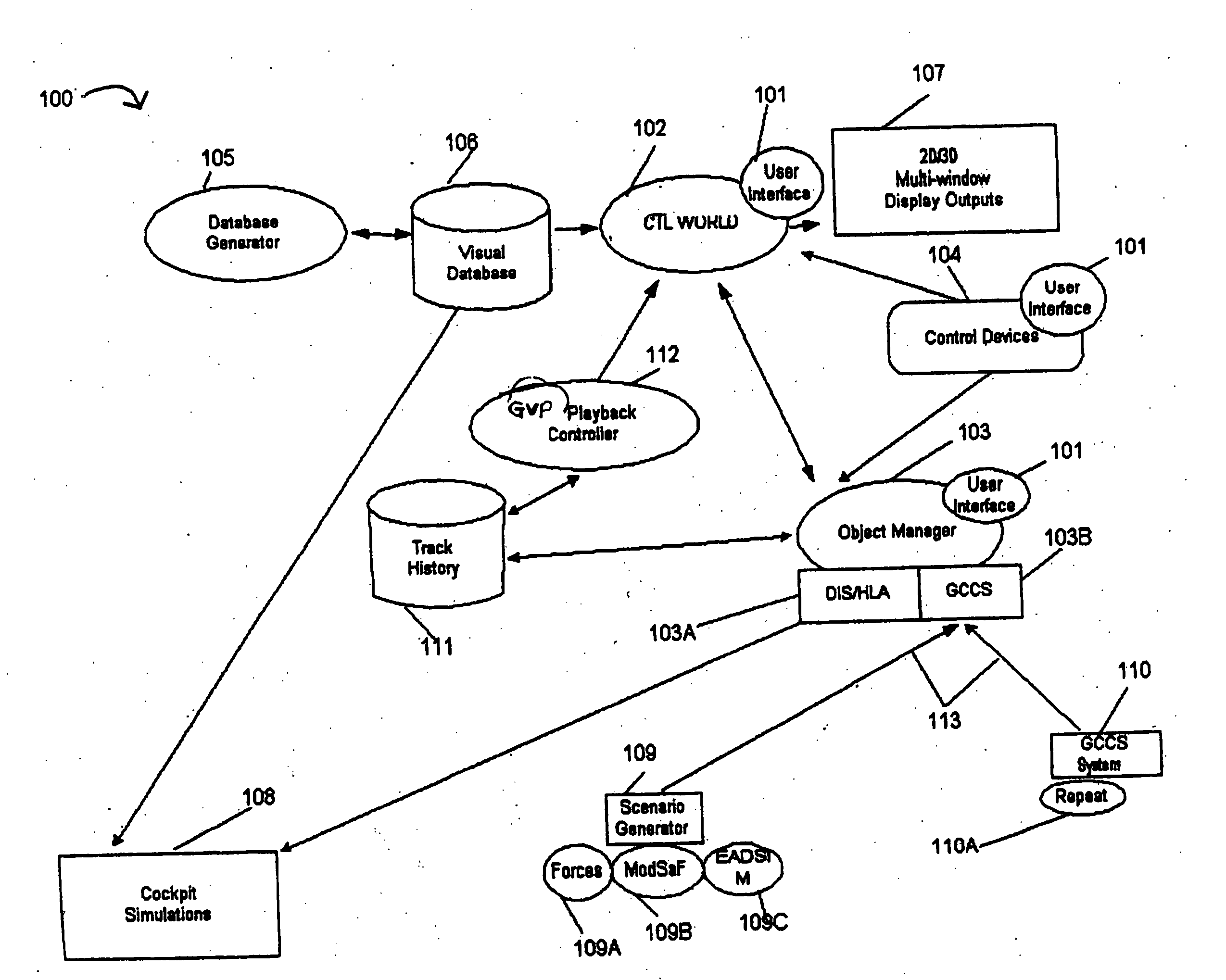
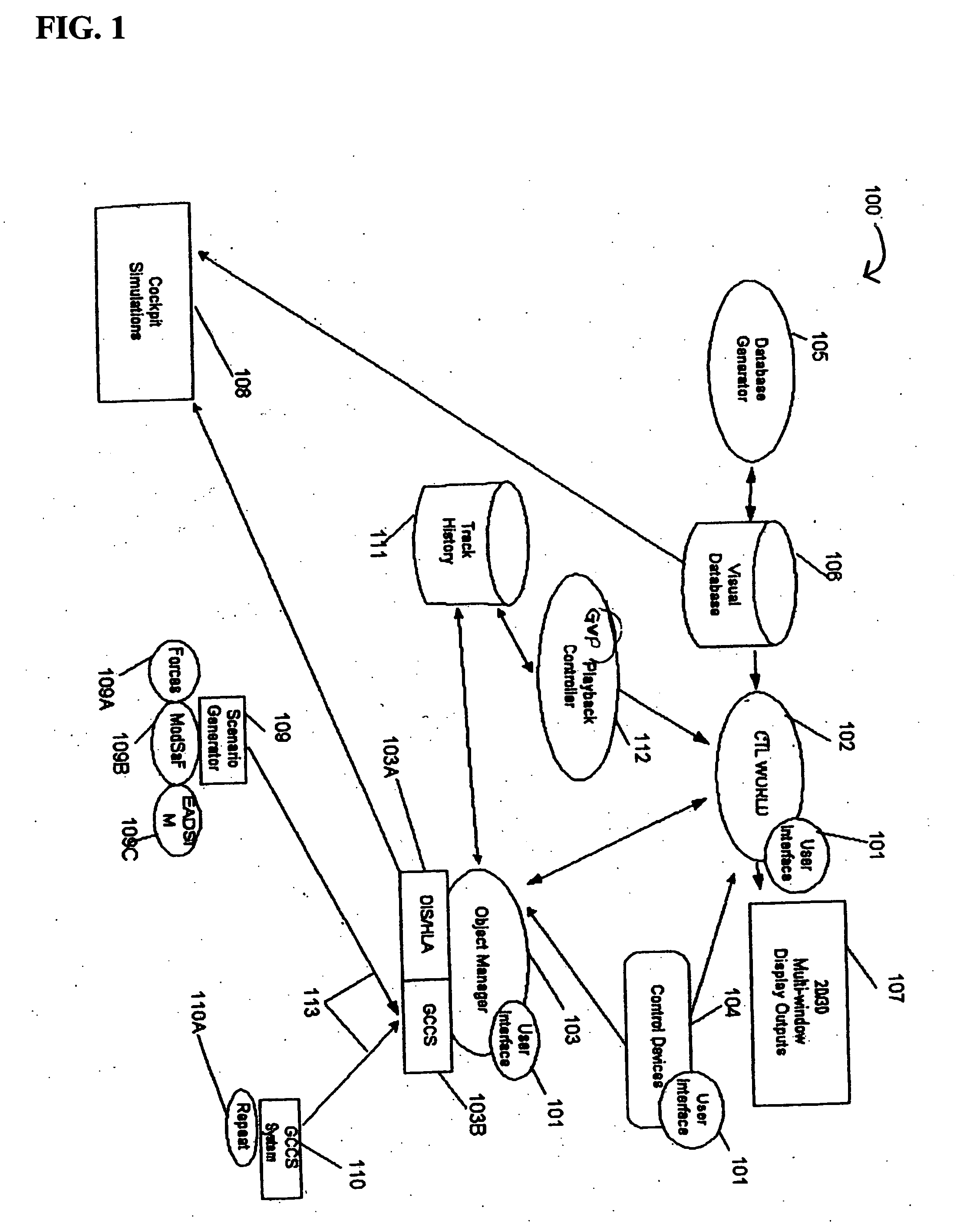
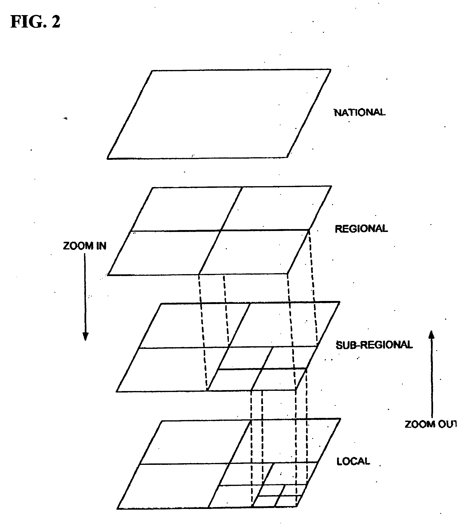
[0021] The Global Visualization Process (GVP) system is an integrated software solution for high-performance visualization. GVP software is capable of displaying extremely high-resolution terrain models and imagery in real time over the entire surface of the planet, as well as a large number of moving entities and their associated graphical models. The system can display imagery at 2 cm / pixel, and infinitely detailed terrain in real time over the whole surface of the planet earth. All displayed data is referenced to the World Geodetic System 1984 (WGS-84) ellipsoid for true round-earth effects, and can be rendered in correct asymmetric stereo. These features, combined with a network application programming interface (API), make GVP suitable for flight simulation out-the-window displays, command and control scenarios, and mission review or rehearsal.
[0090] As with the GVP, and preferably, the embodiments of the present invention GVP+ can be (or should be capable of being) applied to depict any activity requiring a decision maker to undertake one or more of the following actions: plan, coordinate, control, communicate, command, assess, reconnoiter, negotiate, direct, collate, organize, and / or terminate activities, and / or undertake any action related to any of the above, either before or after in time. Sample activities include, but are not limited to, military flight test operations, training, simulations, tests, computer modeling, war games, maneuvers, combat operations, flight guidance or vehicle guidance and / or the command and / or control of (or over) domestic disturbances. Importantly, the realistic training available with the system saves capital equipment, as well as training and maintenance costs, while providing a better-trained individual. It is also capable of providing top-level decision makers with very realistic “hands-on” experience(s) without the expense of participating in an event that could incur significant costs, lives, and / or materials.

Problems solved by technology

Conventional systems suffer from some or all of the following limitations: Highly specific processes and model data formats limit the range of data inputs to a small subset of available information; Video outputs are limited to specific display devices or types; Stereoscopic viewing is not supported or is not controllable; Overall size of operating terrain models is restricted to small areas and the greater the detail (resolution), the smaller the area displayed; When put in motion, as in flight simulation or when the depiction eyepoint is moved, model depiction has unacceptably low update rates; Small numbers of fixed or mobile objects added to the terrain model grossly and unacceptably inhibit the video update rate; Model construction and image computation based on fundamental flat-earth geometry introduces gross positional errors with complex variations in magnitude—these errors confound operations when independent systems interact; Without major revisions to adapt to multi-processor and multi-pipe computer systems, existing software architecture does not fully exploit state-of-the-art graphics-oriented computers; and Conventional systems cannot employ imagery and terrain geometry of mixed resolution, or can do so only with difficulty.

Method used


Image

  • Global visualization process for personal computer platforms (GVP+)
  • Global visualization process for personal computer platforms (GVP+)
  • Global visualization process for personal computer platforms (GVP+)

Examples


examples

[0136] Models suitable for flight simulator operation as out-the-window displays. Because GVP is fully compliant with “round-world” geometry standards, interfaces are facilitated in interactions between simulation models such as DIS that incorporate operational position data in the simulation. The GVP model type and construction and the GVP CTL World display software comprise a standard or uniform product type suitable for “high end” military flight training simulators.

[0137] Unmanned Airborne Vehicle (UAV) and UCAV systems. GVP is suitable for training, multi-platform command and control, reconnaissance and surveillance processes, planning and rehearsal, and rapid prototyping applications.

[0138] Interactive visualization during tactical flight operations. Applications range from mission rehearsal including while deployed or airborne to operational exploitation of near real time tactical intelligence. GVP-based displays, by providing a full visualization context for mission depict...


PUM


Abstract

A system and process that incorporates hardware and software as elements to be combined with procedures and processes to obtain, format, store, combine, control, display, record, and visualize dynamic scenarios by interacting with accurate, realistic models and actual events within, on, and above a three-dimensional surface to be observed or modeled. The present invention software and process is capable of displaying extremely high resolution terrain models and imagery in real time over the entire surface of the planet, as well as a large number of moving entities and their associated graphical models. These features, combined with a network application programming interface (API), make the present invention suitable for flight simulation out-the-window displays, command and control scenarios, and mission review or rehearsal.

Description

CROSS REFERENCE TO RELATED APPLICATIONS [0001] This application is a continuation-in-part, and claims the benefit, of U.S. Nonprovisional application Ser. No. 10 / 255,413, filed on Sep. 26, 2002, which is incorporated herein by reference. Applicants claim the priority date benefits of that application.STATEMENT REGARDING FEDERALLY SPONSORED RESEARCH OR DEVELOPMENT [0002] The invention described herein may be manufactured and used by or for the Government of the United States of America for governmental purposes without payment of any royalties thereon or therefor.REFERENCE TO A SEQUENCE LISTING, A TABLE, OR A COMPUTER PROGRAM LISTING COMPACT DISK APPENDIX [0003] Incorporated by reference is a computer program listing consisting of a listing of program files (attached hereto as Appendix A) and an electronic copy of this listing of program files and the source files of the present invention, which are being submitted concurrently herewith on a compact disc labeled by at least the title...

Claims


Application Information

Patent Timeline
IPC IPC(8): G06T11/20G06T17/40G09G5/00
CPCG06T19/00G06T17/05
Inventor GATEWOOD, WALTER P. JR.FORD, INGI A.VANDROVEC, BRYAN M.MIELCAREK, DONALD G.KIRKPATRICK, DAVID A.
Owner US SEC THE NAVY CHIEF OF NAVAL RES OFFICE OF COUNSEL
Why Eureka
Eureka Blog
Learn More