Methods and apparatus for accessing geospatial information

a geospatial information and access method technology, applied in the field of accessing geospatial information, can solve the problems of limited access methods for accessing geospatial information, limited resources, and complex specifications provided by entities such as the ogc, and achieve the effect of facilitating open-geospatial developmen

Inactive Publication Date: 2006-10-26
CARBON PROJECT
View PDF4 Cites 32 Cited by
  • Summary
  • Abstract
  • Description
  • Claims
  • Application Information

AI Technical Summary

Benefits of technology

[0012] Methods and apparatus are provided for accessing geospatial information. A geospatial toolkit including source, handler, and data modules is configured to access geospatial data from a variety of sources, parse the geospatial data, and provide geospatial data in a unified format. Parameters including source, layer information, boundaries, query filters, etc. are set

Problems solved by technology

However, mechanisms for accessing geospatial information remain limited, complicated, and resource intensive.
Consequently, the specifications provided by entities such as the OGC are generally voluminous, complicated, and detailed.
In many instances, specifications provided by entities such as the OGC are abstract and difficult to implement.
The complex nature of geospatial information also makes implementation of specifications difficult.
Application development complexity is increased because of the need to write detailed interfaces configured to access different types of geospatial data.
Te

Method used


Image

  • Methods and apparatus for accessing geospatial information
  • Methods and apparatus for accessing geospatial information
  • Methods and apparatus for accessing geospatial information

Examples


Embodiment Construction

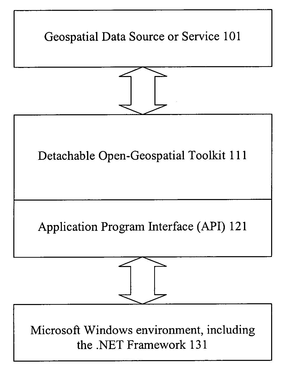
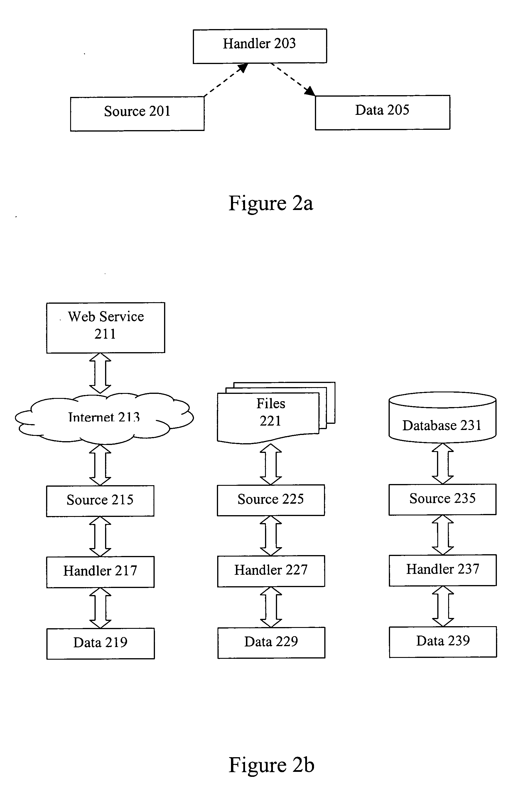
[0027] Reference will now be made in detail to some specific embodiments of the invention including the best modes contemplated by the inventors for carrying out the invention. Examples of these specific embodiments are illustrated in the accompanying drawings. While the invention is described in conjunction with these specific embodiments, it will be understood that it is not intended to limit the invention to the described embodiments. On the contrary, it is intended to cover alternatives, modifications, and equivalents as may be included within the spirit and scope of the invention as defined by the appended claims.

[0028] For example, the techniques of the present invention will be described in the context of fibre channel networks. However, it should be noted that the techniques of the present invention can be applied to different variations and flavors of fibre channel. In the following description, numerous specific details are set forth in order to provide a thorough underst...


PUM


Abstract

Methods and apparatus are provided for accessing geospatial information. A geospatial toolkit including source, handler, and data modules is configured to access geospatial data from a variety of sources, parse the geospatial data, and provide geospatial data in a unified format. Parameters including source, layer information, boundaries, query filters, etc. are set to allow retrieval of diverse geospatial data from different sources while providing a unified presentation on a system interface. The geospatial toolkit can be implemented in a framework such as the Component Object Module (COM) or .NET framework.

Description

CROSS REFERENCE TO RELATED APPLICATIONS [0001] The present application is related to concurrently filed U.S. patent application Ser. No. ______ (Atty Docket No. CARBP002), titled METHODS AND APPARATUS FOR ACCESSING GEOSPATIAL INFORMATION by Hanoch (Nuke) Goldstein, the entirety of which is incorporated by reference for all purposes.BACKGROUND OF THE INVENTION [0002] 1. Field of the Invention [0003] The present invention generally relates to accessing geospatial information. More specifically, techniques of the present invention provide portable tools for efficiently accessing a variety of geospatial information sources and providing the information to applications in a unified format. [0004] 2. Description of Related Art [0005] Geospatial information is any data describing the location, characteristics, and / or features of a particular entity. Geospatial information is highly diverse and includes information from disparate sources such as terrain maps, aerial and satellite images, na...

Claims


Application Information

Patent Timeline
IPC IPC(8): G06F17/30
CPCG06F17/30241G06F16/29
Inventor GOLDSTEIN HANOCH (NUKE)
Owner CARBON PROJECT
Why Eureka
Try Eureka