Method and system for embedding native shape file and mapping data within a portable document format file

a portable document format and mapping data technology, applied in the field of cartography, can solve the problems of gis mapping systems and data so difficult to use, pdf file format cannot handle large documents, and difficulty in providing gis information to the general public,

Inactive Publication Date: 2006-12-21
SKILLEN WILLIAM ANDREW
View PDF7 Cites 60 Cited by
  • Summary
  • Abstract
  • Description
  • Claims
  • Application Information

AI Technical Summary

Benefits of technology

[0019] In another embodiment, the invention includes a method for embedding red-line vectors into an electronic graphics file, and associating the geographic position of the red-line vector in the electronic graphics file with a position in the native geographic information, the method including the steps of receiving an electronic graphics file representing a digital source map, receiving native geographic information associated with the digital source map, receiving a red-line vector in the electronic graphics file, the red-line vector having a geographic position in the electronic graphics file, and embedding the red-line vector into the native geographic information, the embedded vector red-line having a position in the native geographic information associated with the geographic position in the electronic graphics file. The red-line vector may include at least one of the following: text, graphics, points, polylines, polygons, and spheres. The native geographic information may include a comments layer embedded within the electronic graphics file, and embedding the red-line vector into the native geographic information includes embedding the red-line vector into the comments layer. The native geographic information may include a digital shape file embedded within the electronic graphics file; and embedding the red-line vector into the native geographic information includes embedding the red-line vector in the digital shape file. The method may include a method of exporting the red-line vectors from the electronic graphics file and into a digital source map, the method including, exporting a digital shape file from the electronic graphics file, the digital shape file included of a vector red-line, the vector maintaining a position in the digital shape file, and importing the digital shape file, with the embedded vector red-line, into a digital source map, and wherein the position of the vector red-line in the digital source map is associated with a geographic position within the electronic graphics file.

Problems solved by technology

Until recently, the PDF file format could not handle large size documents, nor the complexity associated with today's GIS mapping systems and data.
Because GIS systems are so difficult to use, there has been some difficulty in providing GIS information to the general public.
Both of these approaches have fallen short of delivering the full mapping functionality offered by GIS viewers, which allow for viewing layers, coordinates and attributes for objects in a map.

Method used


Image

  • Method and system for embedding native shape file and mapping data within a portable document format file
  • Method and system for embedding native shape file and mapping data within a portable document format file
  • Method and system for embedding native shape file and mapping data within a portable document format file

Examples


Embodiment Construction

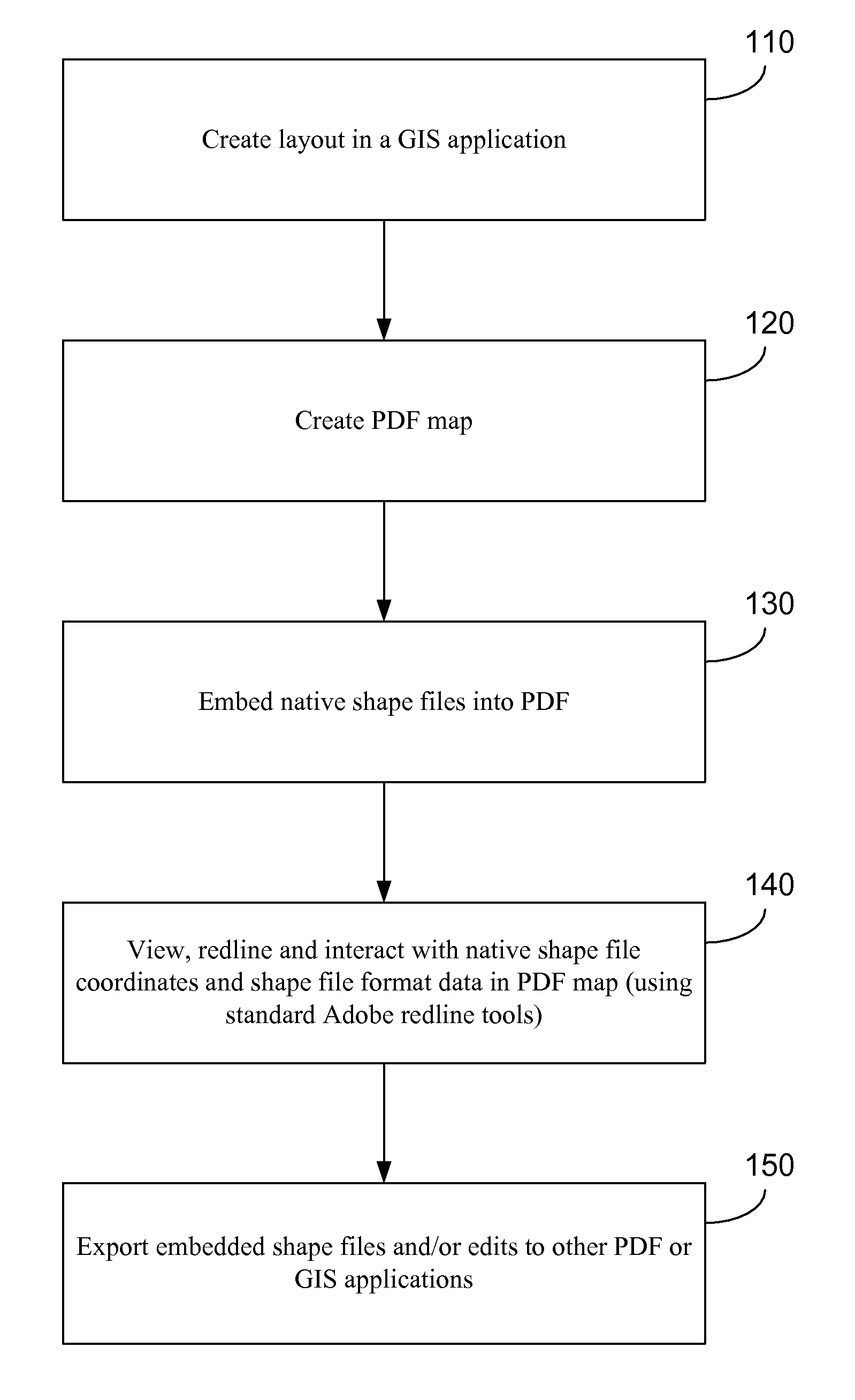
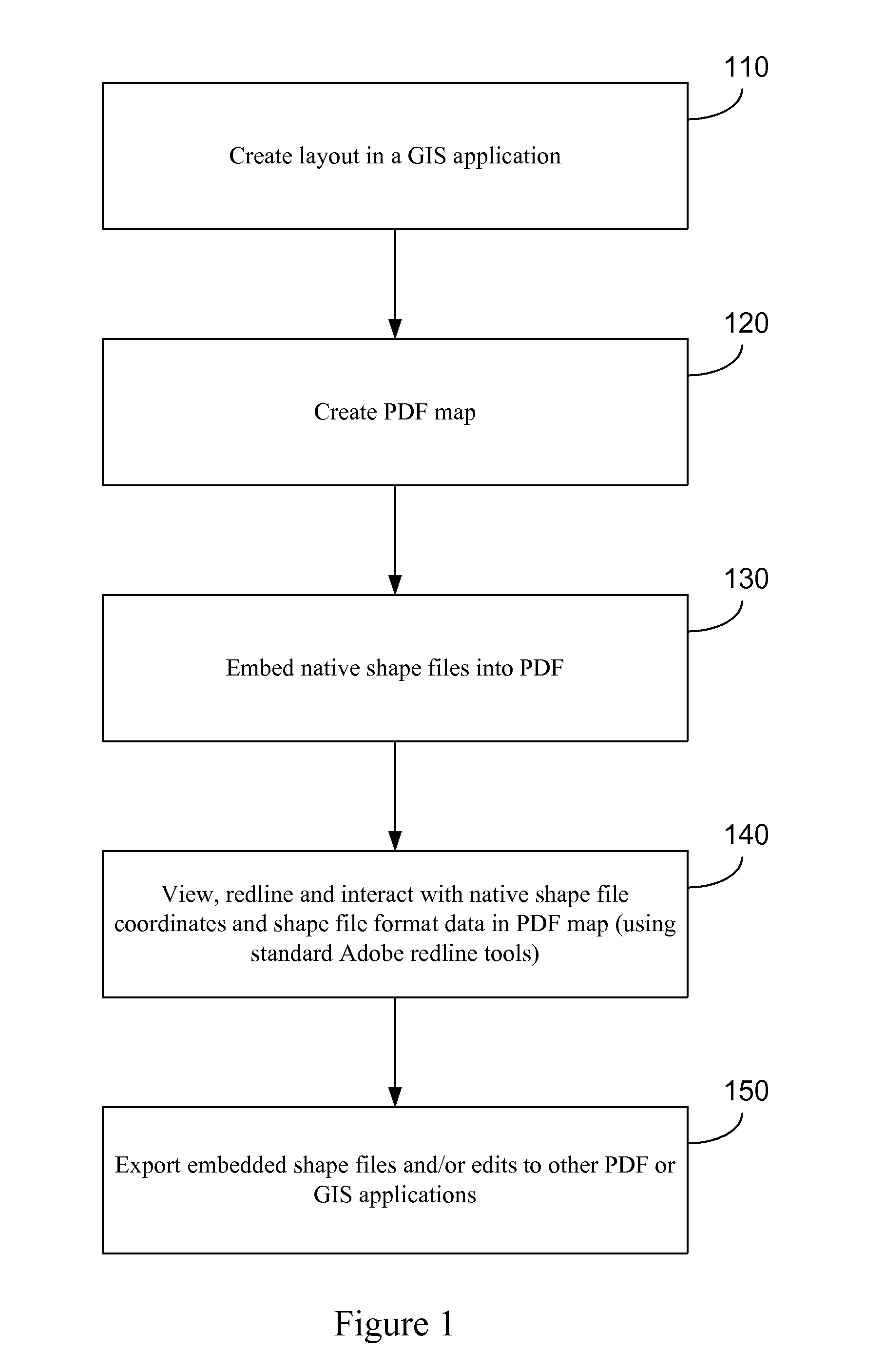
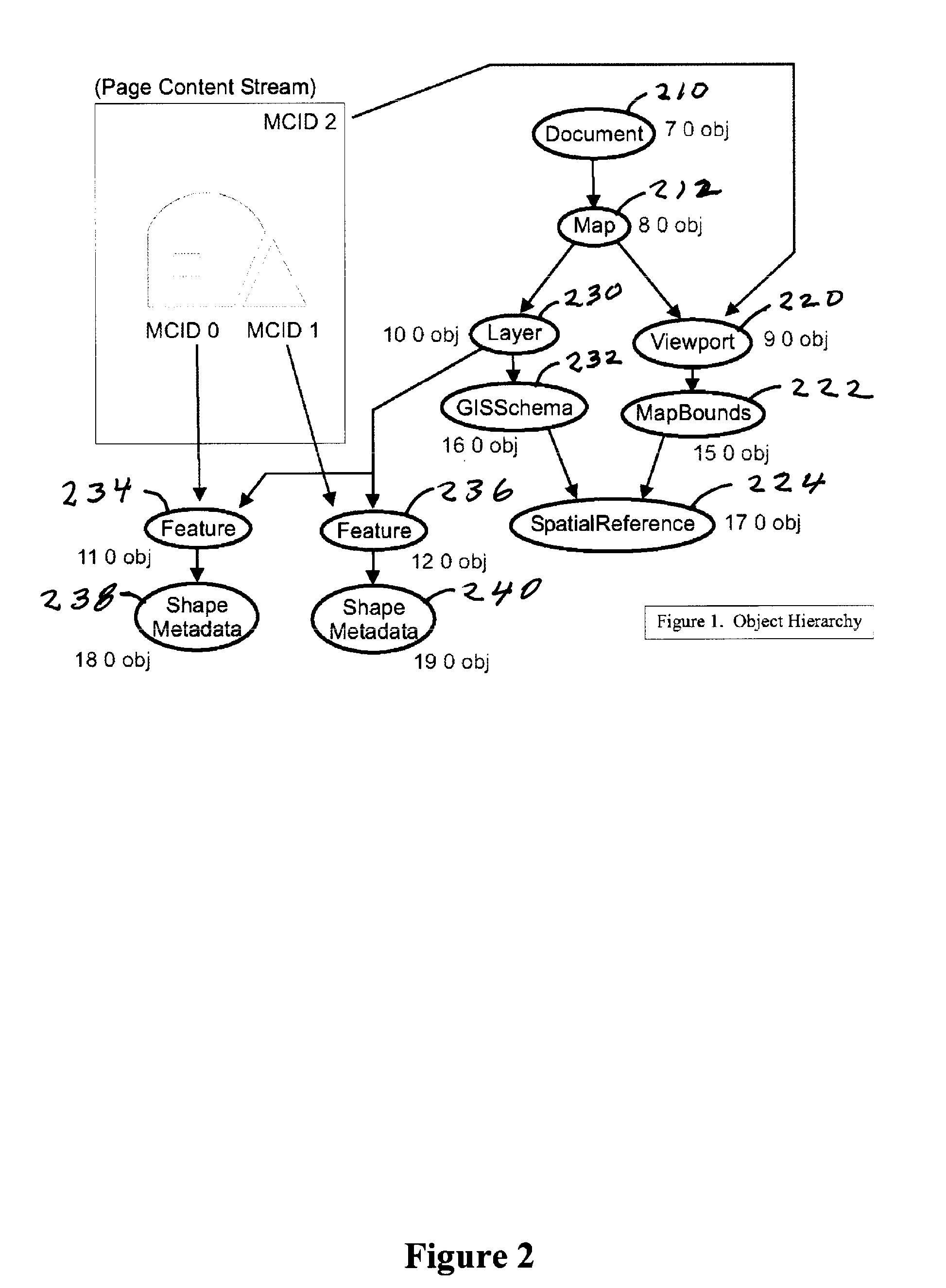
[0027] This invention relates to a system and method for embedding and maintaining native shape file and cartographic (mapping) data from a Geographic Information System (“GIS”) within a portable document format file. As defined herein, “Native” refers to raw GIS source data without the need for massaging, translating or transforming the data. The source data persists in the PDF file as it existed in the GIS file. Native simply refers to the source GIS data as it existed in the particular GIS file. Once this GIS native data has been embedded in the PDF file, it can be viewed and worked with using the Adobe Acrobat or Adobe Reader applications, or other PDF applications as are known to those skilled in the art. A system and methodology for the embedding and display of native shape file coordinates, layers and data objects (shape file vectors; shape file dBASE data and other cartographic information from within the source GIS file) for display within the Portable Document Format (PDF)...


PUM


Abstract

This invention relates to a system and method for embedding and maintaining native shape file and cartographic, or mapping data from a Geographic Information System within a portable document format file. Once this data has been embedded, it can be viewed and worked with using PDF applications such as Adobe Acrobat or Adobe Reader. The invention also discloses a system and methodology for the export of embedded native shape file format coordinates, layers and data objects from within the Portable Document Format (PDF) along with any associated vector red-lines, markups, text edits and database edits made directly to the embedded shape file objects for export back into GIS applications and other applications. The invention utilizes the PDF file format as a true GIS data exchange medium.

Description

CROSS-REFERENCE TO RELATED APPLICATION [0001] This application claims the benefit of U.S. Provisional Application Ser. No. 60 / 691,741 filed on Jun. 17, 2005, which is herby incorporated herein by reference.BACKGROUND OF THE INVENTION [0002] 1. Field of the Invention [0003] The present invention generally relates to cartography and the publishing and usage of maps. More particularly, the invention relates to a method and system for embedding and maintaining native shape file and mapping data within a portable document format file (PDF). [0004] 2. Description of the Related Art [0005] Geographic Information Systems (GIS) are software applications used for the creation and analysis of maps and spatial data. They allow users to create and edit maps, and associate objects in the maps with database information. Maps within a GIS application are also referred to as digital source maps. The primary means for associating database information with a particular geographic location on the map i...

Claims


Application Information

Patent Timeline
Patent Type & Authority Applications(United States)
IPC IPC(8): G06F3/12
CPCG06F17/30241G06F16/29
Inventor SKILLEN, WILLIAM ANDREW
Owner SKILLEN WILLIAM ANDREW
Why Eureka
Try Eureka