Real-time conformal terrain rendering

a technology of conformal terrain and real-time conformal, which is applied in the direction of image generation, multiple digital computer combinations, instruments, etc., can solve the problems of low-performance embedded hardware platforms, inability to provide such 3d terrain displays, and high-performance rendering hardware not available for flight-worthy applications

Inactive Publication Date: 2007-02-01
THE BOEING CO
View PDF44 Cites 6 Cited by
  • Summary
  • Abstract
  • Description
  • Claims
  • Application Information

AI Technical Summary

Problems solved by technology

Although several 3D terrain rendering products are available today, they require high-performance rendering hardware not available for flight-worthy applications.
However, the pre-existing low-performance embedded hardware platforms, i.e. older technology hardware currently install

Method used


Image

  • Real-time conformal terrain rendering
  • Real-time conformal terrain rendering
  • Real-time conformal terrain rendering

Examples


Embodiment Construction

[0012] The following description of the preferred embodiments is merely exemplary in nature and is in no way intended to limit the invention, its application or uses. Additionally, the advantages provided by the preferred embodiments, as described below, are exemplary in nature and not all preferred embodiments provide the same advantages or the same degree of advantages.

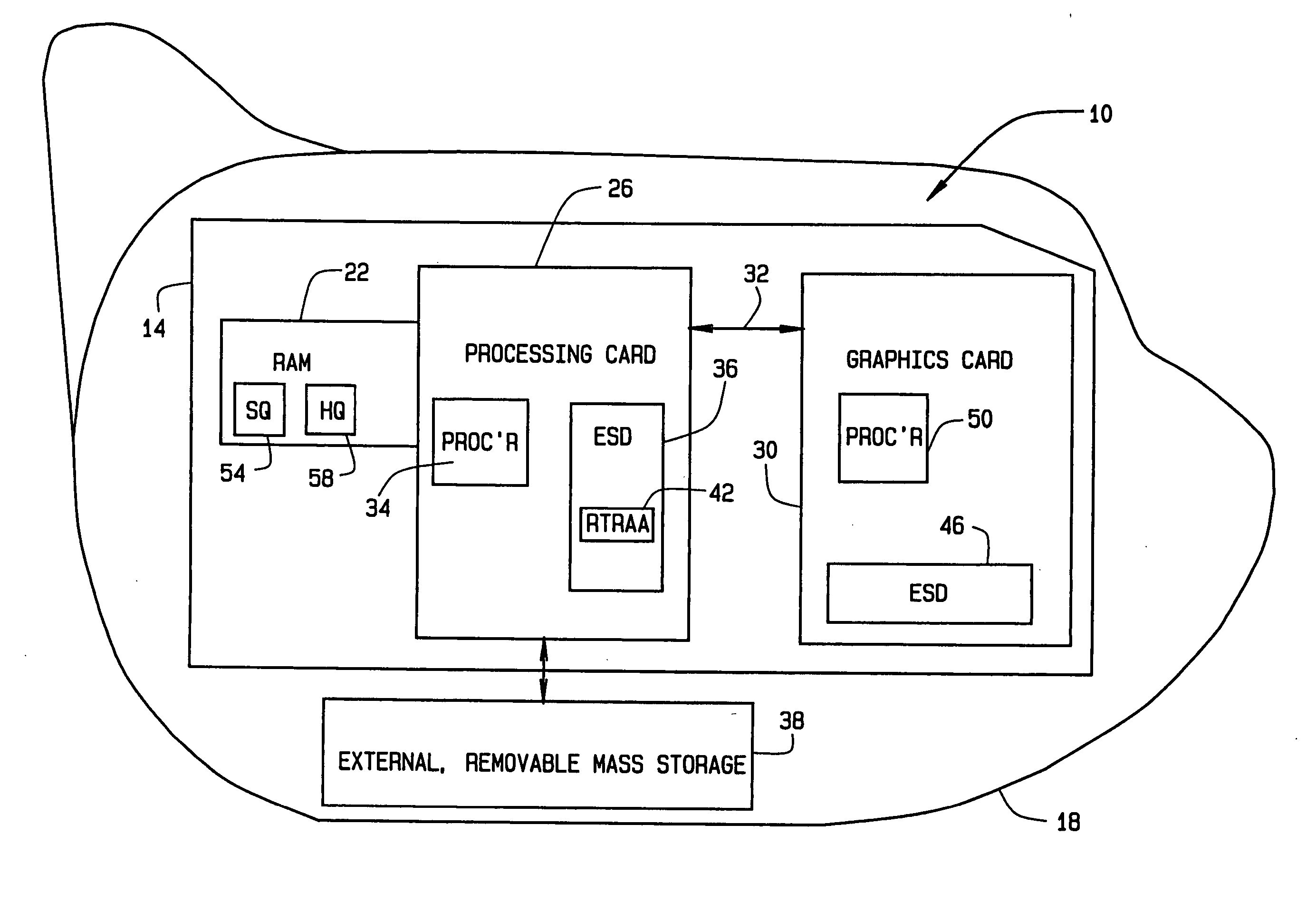
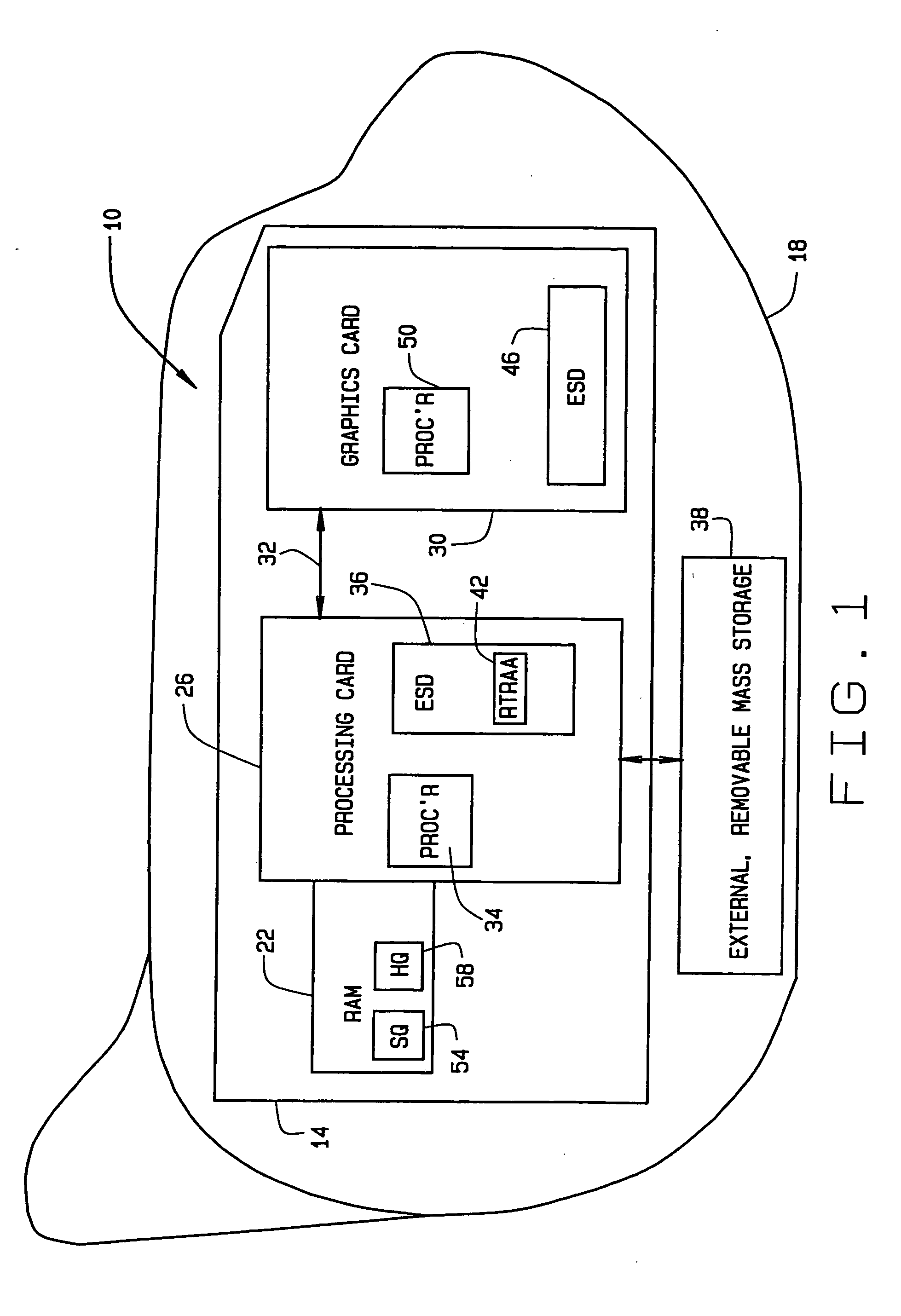
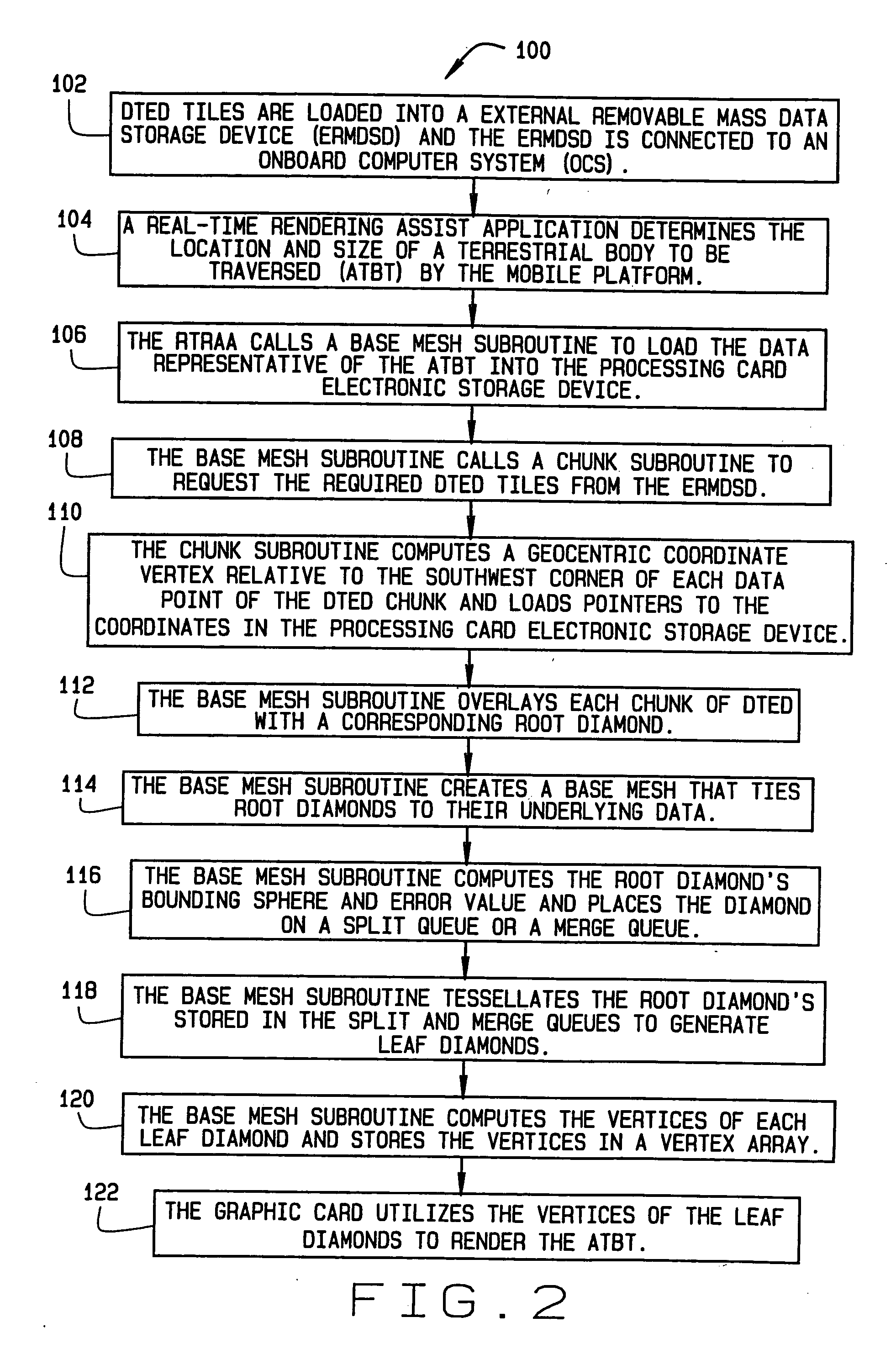
[0013] Referring to FIG. 1, in accordance with various embodiments of the present invention, a real-time rendering assist system 10 is provided to render conformal terrain views to pilot displays. Generally, the conformal view provides an overlay of the actual terrain that a mobile platform is traversing onto what the pilot actually sees through the cockpit windows. There is a one-to-one correspondence with what the pilot sees in the display versus what the pilot sees through the cockpit windows. More particularly, the real-time rendering assist system 10 provides a perspective view of 3-D terrain in such a way tha...


PUM


Abstract

A method for rendering a real-time conformal view of terrestrial body's terrain being traversed by a mobile platform includes storing digital terrain elevation data (DTED) tiles for at least a portion of the terrain of a terrestrial body into an external removable mass data storage device (ERMDSD). The ERMDSD is connectable to an onboard computer system (OCS) comprising embedded mobile platform components that include at least one processing card, at least random access memory (RAM) device and at least one graphics card. The method additionally includes executing a real-time rendering assist application (RTRAA) stored in the processing card to dynamically repackage the DTED tiles into DTED chunks being representative of an area of the terrestrial body to be traversed (ATBT) by the mobile platform. The method further includes executing the RTRAA to create a base mesh of root diamonds representative of the ATBT and tessellate the root diamonds to create a plurality of leaf diamonds. Further yet the method includes utilizing the graphics card only to render the leaf diamonds, thereby generating a real-time conformal view of the ATBT.

Description

GOVERNMENT RIGHTS IN THE INVENTION [0001] This invention was made with Government support under contract number F33615-00-C-6061 awarded by the United States Air Force. The Government has certain rights in this invention.FIELD OF INVENTION [0002] The invention relates generally to mobile platform guidance systems. More particularly, the invention relates to three dimensional (3D) terrain rendering for pilot displays. BACKGROUND OF THE INVENTION [0003] Situation awareness displays, such as helmet-mounted displays, are rapidly becoming required elements of several existing and future mobile platforms and programs. Conformal views of digital terrain data provide a significant increase in almost any situation awareness application. Although several 3D terrain rendering products are available today, they require high-performance rendering hardware not available for flight-worthy applications. [0004] Providing 3D terrain displays involves not only the rendering algorithms, but also involv...

Claims


Application Information

Patent Timeline
IPC IPC(8): G06T17/20G06T17/05
CPCG06T17/05G06T2210/36G06T17/205G06T15/005G06T1/00
Inventor GOYNE, LINDA J.BERNIER, KEN L.CHILDRESS, JEREMY D.
Owner THE BOEING CO
Why Eureka
Try Eureka